2. What famous sea creature lives on the floor of the Chesapeake Bay?
🤯 Mind-Blowing Fact • Grade 2
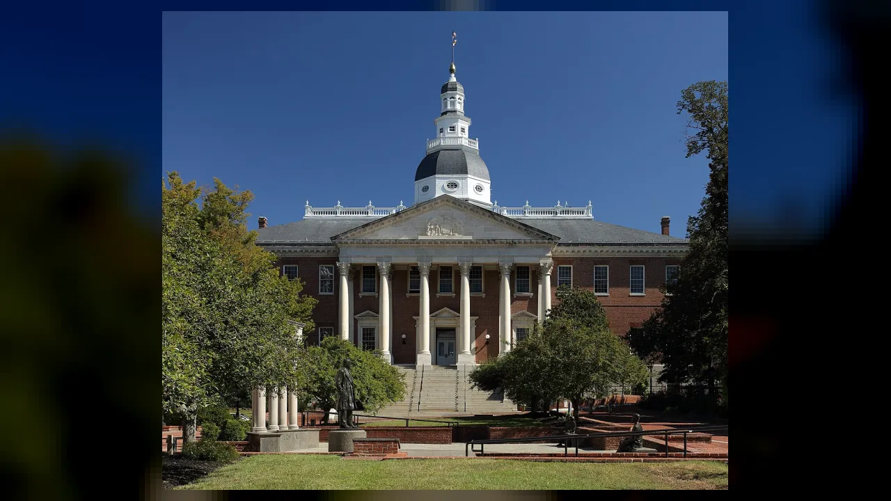
The Maryland State House in Annapolis is the oldest state capitol building still in continuous legislative use in America!
✨ Word Sparks (Grade 2 Glossary)
Tap 🔊 to hear
coastline
The edge where land meets the water
fort
A strong building built to protect soldiers
peninsula
Land with water on almost every side
🪝
How did one stormy night in Baltimore harbor give America its national song?
1
Land Around the Water
Imagine standing on a wooden dock watching seagulls swoop over sparkling waves. The Chesapeake Bay splits Maryland into a Western Shore and an Eastern Shore. Fishing towns, sandy marshes, and tall lighthouses line its busy coast.
2
Annapolis and Mountain Trails
In Annapolis, the state capital, future naval officers study beside historic brick buildings. Travel west from the bay and flat Tidewater farms rise into the green Appalachian Mountains. Along the southern border, the Potomac River separates Maryland from Virginia.
3
The Flag That Stayed Up
Maryland became the seventh state in 1788. During the War of 1812, soldiers defended McHenry in Baltimore all night long. At dawn, Francis Scott Key saw the huge American flag still waving and wrote the poem for our national anthem.
1. What inspired Francis Scott Key to write the words to our national anthem?
2. Which river forms much of the border between Maryland and Virginia?
🤯 Mind-Blowing Fact • Grade 3
Wild horses still roam the beaches and salt marshes of Maryland's Assateague Island beside the Atlantic Ocean!
✨ Word Sparks (Grade 3 Glossary)
Tap 🔊 to hear
estuary
Coastal body mixing river and ocean water
ratify
Officially vote to approve a major law
skipjack
Traditional Chesapeake sailboat built for oyster harvesting
🪝
Why do geographers sometimes call Maryland 'America in Miniature'?
1
Mountains, Farms, and Tides
Drive across Maryland in a single afternoon and watch the landscape transform before your eyes! Sandy Atlantic barrier islands guard wild ponies on Assateague Island in the east. Wide Chesapeake Bay waters divide the flat Coastal Plain from rolling Piedmont hills, while forested Appalachian ridges rise in the west.
2
America's Largest Estuary
The Chesapeake Bay is the largest in the United States, where salty Atlantic tides mix with fresh water from rivers like the Susquehanna and Potomac. Eelgrass beds shelter blue crabs, oysters, and striped bass, supporting watermen who have sailed wooden boats for generations.
3
Colonial Roots and Statehood
Piscataway and Nanticoke peoples fished and farmed these shores long before English settlers arrived at St. Mary's City in 1634. On April 28, 1788, Maryland ratified the U.S. Constitution as the seventh state, earning the nickname Old Line State from its brave Continental Army troops.
4
Heroes of Freedom
Two giant voices for liberty, Harriet Tubman and Frederick Douglass, grew up on Maryland's Eastern Shore. Both escaped slavery and dedicated their lives to helping others win freedom and equal rights across the nation.
1. Why is the Chesapeake Bay classified as an estuary?
2. Which two famous freedom leaders were born on Maryland's Eastern Shore?
🤯 Mind-Blowing Fact • Grade 4
In 1783, George Washington resigned his commission as Commander-in-Chief inside the Maryland State House in Annapolis, proving that elected civilians—not generals—would govern the new republic!
✨ Word Sparks (Grade 4 Glossary)
Tap 🔊 to hear
watershed
All land draining water into one waterway
cede
Formally hand over land by legal agreement
bombard
Attack a fortress heavily with cannon shells
🪝
How did Maryland help shape religious freedom, the nation's capital, and America's fastest early railway?
1
An Estuary That Shapes a Region
Picture nearly two hundred miles of tidal waterways branching like oak roots into quiet coves and bustling ports. Sharing the Chesapeake Bay with neighboring Virginia and Pennsylvania, Maryland packs coastal dunes, fertile Piedmont valleys, and rugged Blue Ridge and Allegheny mountains into just over twelve thousand square miles. Because nearly every major eastern landform appears except desert, travelers nicknamed Maryland 'America in Miniature.'
2
Early Experiments in Self-Government
Long inhabited by Algonquian-speaking Piscataway, Nanticoke, and Accohannock communities, the colony of Maryland was chartered in 1632 for Cecilius Calvert, Lord Baltimore. In 1649, its colonial assembly passed the Maryland Toleration Act, one of the earliest laws in colonial North America granting legal protection to differing Christian congregations. During the Revolutionary War, disciplined Maryland regiments held crucial lines for General George Washington, inspiring the proud nickname Old Line State.
3
Building the Capital and Defending Baltimore
After ratifying the Constitution on April 28, 1788, Maryland ceded territory north of the Potomac River in 1791 to establish Washington, D.C. Just twenty-three years later, during the War of 1812, British warships bombarded Baltimore's star-shaped Fort McHenry for twenty-five hours. Watching the garrison's thirty-by-forty-two-foot flag survive the storm, lawyer Francis Scott Key penned 'Defence of Fort M'Henry,' later set to music as 'The Star-Spangled Banner.'
4
Rails, Ships, and Modern Science
Baltimore soon launched the Baltimore and Ohio Railroad in 1828, America's first common-carrier railroad linking Atlantic ports with the Midwest. Today, Annapolis hosts the United States Naval Academy, while Maryland laboratories lead breakthroughs in space telescopes, medicine, and Chesapeake Bay conservation.
1. Why did Maryland earn the nickname 'The Old Line State'?
2. What historic transportation project began in Baltimore in 1828?
🤯 Mind-Blowing Fact • Grade 5
Engineers at NASA's Goddard Space Flight Center in Greenbelt, Maryland oversaw the assembly and testing of the James Webb Space Telescope, peering at galaxies formed over thirteen billion years ago!
✨ Word Sparks (Grade 5 Glossary)
Tap 🔊 to hear
physiographic
Relating to natural landforms of a region
abolitionist
Person working to end slavery forever
tributary
Smaller river flowing into a larger waterway
🪝
Why did a compact Mid-Atlantic colony flanking the Chesapeake Bay become a crossroads for constitutional union, abolitionist courage, and aerospace innovation?
1
Tidal Geography Along the Fall Line
Trace the Atlantic coastline between Virginia and Delaware, and the Chesapeake Bay immediately commands the map, slicing nearly two hundred miles northward across Maryland. Spanning 12,406 square miles, the state bridges three major provinces: the flat Atlantic Coastal Plain split into Eastern and Western Shores, the rolling crystalline Piedmont, and the folded ridges of the Appalachian Highlands peaking at Backbone Mountain (3,360 feet). Along the geologic Fall Line—where upland rivers tumble over rocky rapids into tidal estuaries—port cities like Baltimore harnessed both waterpower for flour mills and deep-water channels for global trade.
2
Indigenous Homelands and Proprietary Founding
For thousands of years before European contact, Piscataway, Nanticoke, Susquehannock, and Shawnee peoples cultivated corn, beans, and squash while harvesting oysters along Chesapeake tributaries. Granted a royal charter in 1632, Cecilius Calvert, Second Baron Baltimore, envisioned Maryland as a commercial enterprise and a refuge where English Catholics and Protestants could coexist, leading to the landmark 1649 Act Concerning Religion at St. Mary's City.
3
Constitutional Pillar and Star-Spangled Resilience
In Annapolis, delegates gathered in 1786 for the Annapolis Convention, issuing the call that led directly to the 1787 Constitutional Convention in Philadelphia. Maryland ratified the new Constitution on April 28, 1788, as the seventh state, and in 1791 donated roughly sixty-nine square miles along the Potomac River to form the federal capital, Washington, D.C. During September 1814, American defenders at Baltimore's Fort McHenry repelled a British naval fleet; Mary Pickersgill's monumental fifteen-star garrison flag inspired eyewitness Francis Scott Key to compose the verses that Congress designated the national anthem in 1931.
4
Border-State Voices for Human Liberty
Positioned directly south of Pennsylvania's Mason-Dixon Line, nineteenth-century Maryland stood at the center of the struggle over slavery. Born enslaved on the Eastern Shore, Frederick Douglass taught himself to read in Baltimore shipyards before becoming a towering orator, while Dorchester County native Harriet Tubman repeatedly risked her life guiding freedom seekers northward along the Underground Railroad.
5
Modern Maritime, Medical, and Space Leadership
From the United States Naval Academy founded in Annapolis in 1845 to the National Institutes of Health in Bethesda and NASA's Goddard Space Flight Center in Greenbelt—where engineers helped build and operate the Hubble and James Webb Space Telescopes—Maryland connects centuries of maritime heritage with twenty-first-century discovery.