⚡ Everyday Impact SparkCharts the 71% of Earth covered by seawater—mapping hidden seafloors and giant ocean currents that shape our weather
🤯 Mind-Blowing Fact • Grade 1
Salty oceans cover more than seventy percent of planet Earth—making our home look like a bright blue marble from space!
✨ Word Sparks (Grade 1 Glossary)
Tap 🔊 to hear
sonar
using sound echoes to map underwater shapes
current
a steady moving river of ocean water
trench
a super-deep canyon on the ocean floor
🪝
Did you know taller mountains and deeper canyons hide at the bottom of the ocean than anywhere on land?
1
Sailing Out on Big Ships
Splash! Salty spray mists the deck of a big white science ship. Out on the wide blue sea, ocean scientists lower shiny metal bottles deep down on strong cables.
2
Mapping the Dark Seafloor
Ping! Sound waves bounce off the dark ocean bottom and echo back up. Computers turn those echoes into colorful maps of hidden underwater mountains!
3
Rivers Inside the Sea
Floating buoys also track warm ocean that carry heat around our whole planet!
1. How do ocean scientists map mountains hidden deep in dark water?
2. About how much of Earth's surface is covered by salty ocean water?
🤯 Mind-Blowing Fact • Grade 2
Earth's longest mountain range—the Mid-Ocean Ridge—winds 40,000 miles across the seafloor like the seam on a baseball!
✨ Word Sparks (Grade 2 Glossary)
Tap 🔊 to hear
Gulf Stream
warm Atlantic current flowing north past Virginia
salinity
amount of dissolved salt inside ocean water
submersible
small deep-diving craft built for crushing pressure
🪝
Why are ocean scientists different from marine biologists—what else hides in the sea besides fish?
1
Studying the Whole Ocean System
While marine biologists focus on whales, coral, and fish, ocean scientists study the giant ocean itself! From rolling research vessels, they investigate how salty waves move, what chemicals dissolve in seawater, and how underwater volcanoes build brand-new islands.
2
Robot Submarines and Water Bottles
Down into pitch-black water goes a wheel of gray sample tubes called a rosette, snapping shut at different depths to bring cold deep-sea water back on deck. Yellow torpedo-shaped robot gliders also cruise across oceans for months, surfacing to beam data to satellites.
3
Earth's Giant Thermostat
Warm currents like the flow north past Virginia's coast, carrying tropical warmth toward Europe and shaping weather on land!
1. What is the main focus of an oceanographer compared to a marine biologist?
2. What warm ocean current flows northward off the Atlantic coast past Virginia?
🤯 Mind-Blowing Fact • Grade 3
If you placed Mount Everest at the bottom of the Pacific's Mariana Trench, more than a mile of ocean water would still cover its peak!
✨ Word Sparks (Grade 3 Glossary)
Tap 🔊 to hear
continental shelf
shallow underwater edge bordering a continent's coast
abyssal plain
wide flat deep-ocean floor covered in sediment
plankton
tiny drifting ocean plants and microscopic creatures
🪝
How did a woman drawing maps from sonar echoes in the 1950s prove that continents really move?
1
Marie Tharp Maps the Hidden Floor
For thousands of years, sailors assumed the deep ocean floor was mostly flat mud. Then in the 1950s, geological oceanographer Marie Tharp carefully plotted millions of ship sonar pings by hand—revealing a giant rift valley splitting the Mid-Atlantic Ridge! Her map proved the seafloor was spreading apart and moving continents.
2
Four Branches Working Together
Oceanography brings four sciences onto one ship. Physical specialists measure waves, tides, and currents; chemical researchers test salinity, oxygen, and carbon levels; geological teams drill seafloor mud cores to read past climates; and biological partners track tiny drifting that produce half of Earth's oxygen!
3
Continental Shelf to Deep Trench
Leaving coastal ports like Norfolk, Virginia, ships cross the gently sloping before plunging down the steep continental slope onto the flat —and down into trenches deeper than Mount Everest is tall!
4
Black Smokers in the Dark
Using remotely operated vehicles (ROVs), crews explore scalding deep-sea hydrothermal vents where mineral chimneys bubble miles below sunlight.
1. What major discovery did Marie Tharp's famous seafloor map reveal in the 1950s?
2. Which shallow seafloor feature stretches gently outward right off Virginia's coastline before dropping steep and deep?
🤯 Mind-Blowing Fact • Grade 4
Four thousand robotic Argo floats drift across Earth's oceans right now—automatically diving over a mile deep and surfacing every ten days to text ocean temperatures to satellites!
✨ Word Sparks (Grade 4 Glossary)
Tap 🔊 to hear
gyre
giant circular system of rotating ocean currents
thermohaline
deep ocean currents driven by temperature and salt
estuary
coastal bay where fresh rivers meet seawater
🪝
Why did Virginia pioneer Matthew Fontaine Maury earn the nickname 'Pathfinder of the Seas'—and what drives the ocean's thousand-year conveyor belt?
1
Virginia's Pathfinder of the Seas
Born near Fredericksburg, Virginia, in 1806, naval officer Matthew Fontaine Maury studied thousands of dusty captains' logbooks after a stagecoach injury ended his sea duty. Mapping seasonal winds and ocean currents across the globe, he published the first Wind and Current Charts in 1847—slashing sailing times from New York to California by weeks and founding modern operational oceanography!
2
Surface Gyres and the Deep Conveyor Belt
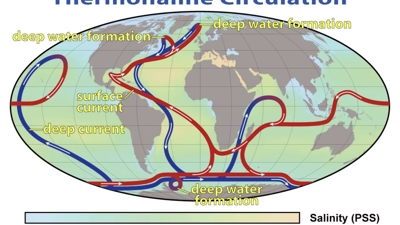
Today's physical oceanographers track two connected motion systems. At the surface, prevailing winds and Earth's rotation spin giant circular loops called , including the North Atlantic's fast Gulf Stream. Far below, cold, extra-salty water near Greenland and Antarctica grows dense enough to sink miles to the abyssal floor—driving a slow global ' conveyor belt' that takes roughly a thousand years to circle the planet!
3
CTD Rosettes and the Argo Fleet
Aboard research ships run by NOAA, Woods Hole, Scripps, and the Virginia Institute of Marine Science, crews lower CTD (Conductivity, Temperature, and Depth) rosettes while four thousand robotic Argo floats drift across every ocean—diving a mile deep every ten days to measure heat content.
4
Guarding Estuaries and Global Climate
Oceans absorb over ninety percent of excess atmospheric heat and roughly a quarter of human carbon dioxide emissions. Chemical oceanographers closely monitor pH shifts that challenge oyster shells in estuaries like Chesapeake Bay, helping coastal communities protect fisheries and shorelines.
1. How did Virginia's Matthew Fontaine Maury revolutionize ocean travel in the 1840s?
2. What makes polar ocean water dense enough to sink miles down and drive deep currents?
🤯 Mind-Blowing Fact • Grade 5
Orbiting radar altimeter satellites can spot giant uncharted underwater mountains miles deep because a seamount's extra rock gravity pulls a tiny bulge of seawater up above it!
✨ Word Sparks (Grade 5 Glossary)
Tap 🔊 to hear
multibeam
wide fan of sonar pings mapping seafloors
chemosynthesis
making food energy from deep-sea vent chemicals
hypoxia
low dissolved oxygen levels inside coastal waters
🪝
Why have humans mapped 100% of Mars at sharp resolution yet less than 30% of Earth's own seafloor—and how are oceanographers closing that frontier?
1
Seeing Through Four Kilometers of Seawater
Electromagnetic radar waves from satellites map Venus and Mars with ease, yet seawater absorbs light and radio frequencies within tens of meters—leaving over seventy percent of Earth's ocean floor unmapped by direct high-resolution instruments! To illuminate this abyssal frontier, oceanographers equip ice-strengthened research vessels and uncrewed surface vehicles with hull-mounted echosounders. Fanning hundreds of acoustic beams across a wide swath, multibeam sonar calculates travel time and signal intensity to reveal seamounts, submarine landslide canyons, and transform faults at meter-scale precision.
2
Thermohaline Overturning and Satellite Altimetry
Earth's climate stability hinges on the Atlantic Meridional Overturning Circulation (AMOC) and global thermohaline pathways, which transport petawatts of equatorial heat poleward. Physical oceanographers combine moored acoustic Doppler current profilers with NASA-CNES SWOT (Surface Water and Ocean Topography) radar altimetry satellites. Incredibly, subtle centimeter-scale hills and valleys on the sea surface—measured from orbit—reflect both geostrophic current speeds and the gravitational pull of massive uncharted seamounts miles below!
3
Carbon Chemistry, Paleoclimate Cores, and Hydrothermal Vents
Chemical oceanographers track the global carbon pump: as surface waters absorb atmospheric CO2, carbonic acid lowers seawater pH and reduces carbonate ions needed by pteropods, corals, and bivalve larvae. Meanwhile, paleoceanographers aboard scientific drilling ships extract hundred-meter sediment cores packed with microscopic foraminifera shells; oxygen-isotope ratios locked in calcium carbonate preserve millions of years of ice-age temperature history. Deeper still, titanium-hulled submersibles like Alvin sample 350-degree-Celsius hydrothermal 'black smokers' where chemosynthetic microbes thrive without sunlight.
4
Estuarine Physics and Coastal Resilience
Closer to shore in drowned river valleys like the Chesapeake Bay—North America's largest estuary—coastal oceanographers model salt-wedge stratification, hurricane storm-surge inundation, and nutrient-driven summer zones, advising watershed partnerships on oyster-reef breakwaters and marsh restoration.
5
Seabed 2030 and Global Ocean Stewardship
Cooperating across borders through international initiatives like Seabed 2030 and the Global Ocean Observing System, oceanographers unite acoustics, autonomous robotics, and biogeochemistry to safeguard tsunami warning networks, subsea communications, and our living blue planet.