1. Which way does rainwater always flow across a watershed?
2. Why does picking up litter in a park help fish in a faraway river?
🤯 Mind-Blowing Fact • Grade 2
Along North America's Continental Divide in the Rocky Mountains, rain on the west side flows to the Pacific Ocean while rain on the east reaches the Atlantic!
✨ Word Sparks (Grade 2 Glossary)
Tap 🔊 to hear
Divide
High ridge separating two neighboring watersheds
Tributary
Smaller stream or river feeding a larger one
Runoff
Rainwater flowing across land into nearby streams
🪝
How can two raindrops falling inches apart on a mountain end up in two different oceans?
1
High Ridges Called Divides
Cup your two hands together like a bowl and mist water on top! Every drop slides down toward the middle. A watershed works just like that giant bowl of land, bordered along its rim by high hills or mountain ridges called .
2
Splitting on the Ridge
If two raindrops land on opposite sides of a sharp mountain , they roll down different slopes! One drop joins streams heading east, while its neighbor joins streams heading west.
3
Small Creeks to Mighty Rivers
Smaller streams that flow into a bigger river are called tributaries. Like branches on a tree joining one sturdy trunk, tributaries gather water across the whole watershed.
1. What landform forms the outer boundary rim between two different watersheds?
2. What do scientists call a smaller creek that flows into a larger main river?
🤯 Mind-Blowing Fact • Grade 3
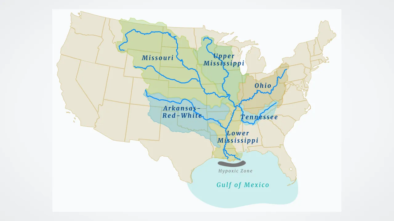
The Mississippi River Watershed is North America's largest drainage basin, collecting water from thirty-two U.S. states and two Canadian provinces!
✨ Word Sparks (Grade 3 Glossary)
Tap 🔊 to hear
Drainage Basin
Another scientific name for a complete watershed
Wetland
Marshy or swampy land that filters runoff water
Water Quality
How clean and healthy water is for life
🪝
What does the famous Earth science saying 'We all live downstream' really mean?
1
Nested Bowls Within Bowls
Crumple a piece of wax paper, flatten it slightly, and spray blue water on the peaks! Water pools in tiny creases that pour into bigger valleys. Watersheds—also called —nest inside one another the exact same way.
2
Your Local Watershed Address
Just like your home sits in a town inside a state inside a country, your neighborhood creek watershed nests inside a larger river watershed, which drains into an ocean basin! Only high mountain divides separate one giant basin from another.
3
Wetlands as Natural Filters
As stormwater runoff travels across farms, forests, and parking lots, marshes and forested act like nature's sponges. Wetland plants soak up floodwater, trap muddy sediment, and filter out extra nutrients before water reaches lakes or bays.
4
We All Live Downstream
Because water carries whatever it touches downhill, neighbors upstream affect for towns downstream—reminding everyone to keep watersheds healthy!
1. How do marshes and forested wetlands help protect a watershed?
2. How can one backyard belong to a small creek watershed and a giant river watershed at the same time?
🤯 Mind-Blowing Fact • Grade 4
New River in southwestern Virginia is actually one of the oldest rivers on Earth, and instead of flowing east to the Atlantic, it flows north and west all the way to the Gulf of Mexico!
✨ Word Sparks (Grade 4 Glossary)
Tap 🔊 to hear
Estuary
Coastal bay where fresh rivers mix with seawater
Impervious
Hard surface like pavement blocking soaking rainwater
Buffer Zone
Strip of trees beside streams trapping muddy runoff
🪝
Did you know rain falling in different parts of Virginia drains to three completely different coastal destinations?
1
Virginia's Three Major Watershed Systems
Trace Virginia's winding rivers on a relief map, and you will discover that mountain divides split the Commonwealth into three major watershed destinations! Over half of Virginia—fed by the Shenandoah, Potomac, Rappahannock, York, and James rivers—drains into the Chesapeake Bay. Southern rivers like the Roanoke and Chowan flow to the North Carolina Sounds, while southwestern rivers like the New and Clinch flow west to the Gulf of Mexico via the Mississippi!
2
Estuaries Where Rivers Meet the Sea
Stretching across parts of six states—New York, Pennsylvania, Maryland, Delaware, West Virginia, and Virginia—plus Washington, D.C., the 64,000-square-mile Chesapeake Bay watershed funnels freshwater into North America's largest . Inside that semi-enclosed bay, fresh river water mixes with salty Atlantic Ocean tides to shelter blue crabs, oysters, striped bass, and underwater eelgrass.
3
Impervious Surfaces vs. Living Buffers
Forested soil absorbs most rainfall into cool groundwater. Paved roads, rooftops, and parking lots, however, create surfaces where stormwater races rapidly into storm drains, eroding streambanks and washing fertilizer and pet waste downstream.
4
Stewardship Across Six States
Planting streamside forest buffers, building rain gardens, and restoring filter-feeding oyster reefs help communities from upstate New York to Virginia Beach keep their shared Chesapeake watershed sparkling.
1. Which three major water bodies ultimately receive water draining from Virginia's watersheds?
2. How do paved impervious surfaces like big parking lots change runoff inside a watershed?
🤯 Mind-Blowing Fact • Grade 5
The Amazon River Watershed drains nearly forty percent of South America and pours roughly fifty-five million gallons of freshwater into the Atlantic Ocean every single second—more than the next seven largest rivers combined!
✨ Word Sparks (Grade 5 Glossary)
Tap 🔊 to hear
Endorheic Basin
Closed inland watershed with no outlet to oceans
Nonpoint Pollution
Runoff pollution gathered broadly across many land surfaces
Eutrophication
Excess nutrients sparking oxygen-draining algae blooms in water
🪝
How do hydrologists number every stream on Earth from 1 to 12—and why does the Chesapeake Bay hold a 14-to-1 land-to-water secret?
1
Topographic Divides and Strahler Stream Order
Study a digital elevation model of North America, and five continental divides partition the landmass into vast oceanic megabasins draining toward the Atlantic, Pacific, Arctic, Gulf of Mexico, and internal like Utah's Great Basin (which has zero outlet to the sea!). Within every watershed, hydrologists organize branching networks using Strahler stream order: tiny unbranched headwater creeks are first-order streams; two first-order streams join to form a second-order stream; two second-order streams form a third-order river; and the Amazon—Earth's largest watershed at seven million square kilometers—reaches twelfth order!
2
The Water Budget Equation
Hydrologists track every drop inside a watershed using a conservation equation: Precipitation equals Surface Runoff plus Evapotranspiration (evaporation plus water transpired by tree leaves) plus Change in Groundwater Storage. Dense forests intercept rain on leaf canopies and channel water into porous root zones, flattening flood peaks and sustaining cool summer baseflow.
3
Chesapeake Bay's 14:1 Land-to-Water Ratio
Why is the Chesapeake Bay unusually sensitive to land use across its 166,000-square-kilometer (64,000-square-mile) watershed? Its land-to-water surface ratio is roughly 14 to 1—the largest ratio of any coastal water body on Earth, seven times higher than most bays! Furthermore, the Bay averages only 6.5 meters (21 feet) deep, meaning excess nitrogen and phosphorus runoff from farms, lawns, and cities concentrates quickly.
4
Preventing Eutrophication and Dead Zones
When excess fertilizer nutrients wash downstream—known as nonpoint-source pollution because it comes from diffuse surfaces rather than a single factory pipe—they trigger explosive algae blooms called . When those algae die and sink, decomposing bacteria consume dissolved oxygen in deep bottom waters, creating summer hypoxic 'dead zones' stressful for crabs and fish.
5
Watershed Science in Action
By combining satellite land-cover maps, automated USGS stream gauges, riparian forest restoration, agricultural cover crops, and wastewater upgrades, multi-state watershed partnerships prove that managing the land heals the water.