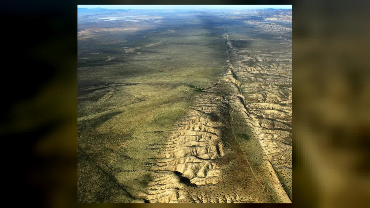
1. In which U.S. state can you see the San Andreas Fault on land?
2. How do the two big slabs of rock move along the San Andreas Fault?
🤯 Mind-Blowing Fact • Grade 2
Millions of years from now, steady sliding along the San Andreas Fault will carry Los Angeles right alongside San Francisco!
✨ Word Sparks (Grade 2 Glossary)
Tap 🔊 to hear
boundary
The border line where two areas meet together.
pressure
A strong pushing force building up against something.
pacific plate
The giant rocky slab beneath the Pacific Ocean.
🪝
Why are streams and fences in parts of California slowly bending sideways?
1
A Rare Seam on Dry Land
Press your palms tightly together and slide one hand forward. You just modeled how California's famous fault works! Most plate edges hide deep under the ocean, yet the San Andreas Fault slices across dry land for nearly 800 miles.
2
Two Huge Neighbors
On the west side sits the , carrying Los Angeles northward. On the east side sits the North American Plate, holding most of the continent. Every year, they inch past each other by about two inches.
3
Crooked Creeks and Quakes
In some spots, soft underground rock lets the plates glide smoothly, slowly bending roads and creeks. Where jagged rock locks tight, builds until the fault snaps forward in a powerful earthquake.
1. About how far does the San Andreas Fault stretch across California?
2. Why do most people find the San Andreas Fault easier to visit than other plate boundaries?
🤯 Mind-Blowing Fact • Grade 3
Pinnacles National Park in California holds half of an ancient volcano that the San Andreas Fault sliced in two and carried 195 miles north of its other half!
✨ Word Sparks (Grade 3 Glossary)
Tap 🔊 to hear
transform boundary
A plate border where slabs slide horizontally past.
fracture
A crack or break inside solid rock layers.
rupture
A sudden break when trapped rock snaps free.
🪝
What happens when two continent-sized slabs of rock try to squeeze past each other without getting stuck?
1
A Scar Seen From the Sky
Fly in a small plane over California's Carrizo Plain, and the ground below looks sliced by a giant plow. Long ridges, trough-like valleys, and sharply bent stream beds mark the path of the 1,200-kilometer San Andreas Fault.
2
A Transform Plate Boundary
Geologists classify this zone as a . Here, the Pacific Plate grinds northwestward past the North American Plate at roughly three to five centimeters per year. Neither plate sinks or melts, so no volcanoes form along the fault.
3
Fault Zones, Not One Thin Line
Rather than one neat crack, the fault is really a complex network of parallel spreading kilometers wide. When rough rock faces snag, elastic energy stores up like a stretched rubber band until the rock .
4
Learning From 1906
In 1906, a sudden shook San Francisco and shifted fences several meters in seconds! That historic event inspired scientists to invent modern earthquake study and strict building codes.
1. What kind of tectonic plate boundary is the San Andreas Fault?
2. Why aren't active volcanoes lined up directly along the San Andreas Fault?
🤯 Mind-Blowing Fact • Grade 4
Slippery greenish minerals inside the central San Andreas Fault act like natural grease, letting two giant plates slide steadily without giant earthquakes!
✨ Word Sparks (Grade 4 Glossary)
Tap 🔊 to hear
strike-slip
Fault motion where rock blocks slide mostly sideways.
aseismic creep
Slow, steady fault sliding without big earthquakes.
elastic rebound
Bent rock snapping back suddenly during an earthquake.
🪝
Why does the middle section of the San Andreas Fault glide quietly while the northern and southern ends lock up tight?
1
California's Tectonic Dividing Line
Stand astride a narrow gully in central California's Carrizo Plain, and your left foot can rest on the Pacific Plate while your right foot stands on the North American Plate! Stretching roughly 1,200 kilometers from the Salton Sea in the south to Cape Mendocino in the north, the San Andreas Fault is Earth's most studied continental transform boundary, slicing about 16 kilometers deep through the upper crust.
2
Right-Lateral Strike-Slip Motion
Geologists describe the fault as a right-lateral system. If you stand on either plate and look across the fault line, the opposite side steadily shifts to your right at 30 to 50 millimeters per year. Over the past 20 million years, this sideways shear has carried coastal slices of Southern California—including Los Angeles, Santa Barbara, and Monterey—hundreds of kilometers northwest.
3
Locked Segments vs. Aseismic Creep
Curiously, the fault does not behave the same way everywhere. Near the town of Parkfield and Pinnacles National Park, a slippery, clay-like mineral derived from serpentine lubricates the fault zone. This allows the plates to slide smoothly in tiny tremors called . By contrast, northern and southern segments—especially where the fault bends near Los Angeles—clamp tightly together for decades or centuries.
4
Elastic Rebound and ShakeAlert
After the 1906 San Francisco earthquake offset roads by up to six meters, scientist Harry Fielding Reid proposed the theory: crust bends under stress until friction gives way and rock snaps into a new position. Today, dense GPS arrays and the ShakeAlert network detect the fastest seismic waves first, warning phones and trains seconds before strong shaking arrives.
1. If you stand on one side of the San Andreas Fault and look across it, which way does the opposite side move over time?
2. What allows the central section of the San Andreas Fault to creep smoothly instead of locking tightly?
🤯 Mind-Blowing Fact • Grade 5
Scientists drilled more than three kilometers straight through the active San Andreas Fault near Parkfield and pulled up ultra-slippery talc rock—related to baby powder—right from the sliding zone!
✨ Word Sparks (Grade 5 Glossary)
Tap 🔊 to hear
fault gouge
Finely crushed rock powder ground between sliding faults.
transpression
Sideways fault sliding combined with squeezing mountain-building.
asperity
A rough, locked rock patch along a fault.
🪝
How did an ancient disappearing ocean plate give birth to the sideways-sliding San Andreas Fault 30 million years ago?
1
Birth of a Continental Transform System
Thirty million years ago, the San Andreas Fault did not exist; instead, an ancient oceanic slab called the Farallon Plate was subducting beneath western North America. When the spreading ridge behind the Farallon Plate collided with the continental margin, subduction shut down along central California and the Pacific Plate made direct contact with the North American Plate. Because the Pacific Plate was moving northwest relative to North America, a vast right-lateral strike-slip boundary—the San Andreas system—took over.
2
A Braided Master Fault Zone
Stretching roughly 1,200 kilometers from the Mendocino Triple Junction southward to the Salton Trough, the San Andreas is the master strand of a much broader plate-boundary zone up to 100 kilometers wide. Sister faults—such as the Hayward, Calaveras, and San Jacinto faults—accommodate part of the total 46-millimeter-per-year plate motion. Rather than a clean razor cut, each strand consists of pulverized rock flour called and shattered breccia reaching 15 to 20 kilometers down to the brittle-ductile transition.
3
Transpression and the 'Big Bend'
North of Los Angeles, the fault trace swerves westward in a pronounced curve called the Big Bend. Because northwest-drifting crust must push around this corner, horizontal shear combines with compression—a process termed —crumpling strata upward to build the steep Transverse Ranges, including the San Gabriel and San Bernardino Mountains.
4
Creeping Talc vs. Locked Asperities
Deep drilling at the San Andreas Fault Observatory at Depth (SAFOD) near Parkfield solved why central California creeps quietly: super-weak minerals like talc and smectite line the fault core, letting stress bleed off continuously. Conversely, locked northern and southern segments accumulate strain across rough rock patches called asperities, rupturing in major events like the 1857 Fort Tejon (M7.9) and 1906 San Francisco (M7.9) earthquakes.
5
From Reid's Fence Posts to InSAR
Measuring offset fences after 1906 led Harry Fielding Reid to formulate elastic rebound theory, the cornerstone of modern seismology. Today, satellite radar interferometry (InSAR) and borehole seismometers map millimeter-scale crustal strain across California every day.