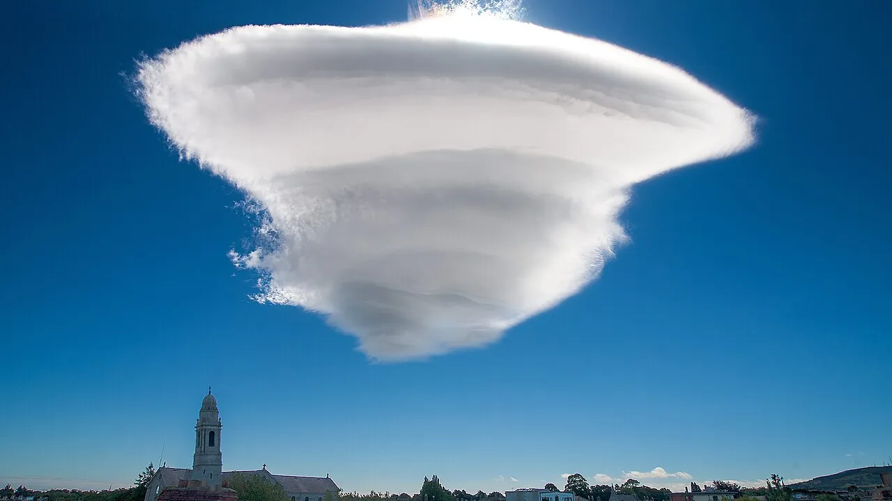
1. Where are you most likely to spot a smooth lenticular cloud?
2. What shape makes lenticular clouds so famous and surprising?
🤯 Mind-Blowing Fact • Grade 2
Multiple layers of moist air flowing over a peak can stack five or six lenticular clouds like a tower of pancakes!
✨ Word Sparks (Grade 2 Glossary)
Tap 🔊 to hear
summit
the highest point on a mountain
upwind
the side from which the wind blows
lens
a curved shape thicker in the middle
🪝
How can a cloud stand completely still while fifty-mile-per-hour winds roar right through it?
1
Shaped Like a Giant Lens
Imagine hiking near a snowy volcano and spotting three smooth, white disks stacked neatly above its ! Meteorologists call them lenticular clouds, from a Latin word meaning shaped like a lentil bean or a magnifying .
2
Invisible Ripples in the Sky
Just as water ripples smoothly over a big rock in a creek, fast, damp wind ripples upward when it hits a tall mountain. At the cold top of that invisible air wave, water gas turns into tiny cloud droplets.
3
Born in Front, Gone in Back
New droplets constantly form on the edge and vanish on the downwind edge as air sinks and warms. That clever trick keeps the cloud parked in one spot!
1. Why does a lenticular cloud appear to stay parked in one place?
2. What does a mountain do to fast, moist air to create lenticular clouds?
🤯 Mind-Blowing Fact • Grade 3
Glider pilots riding smooth mountain waves beside lenticular clouds over the Andes Mountains have soared higher than 76,000 feet without an engine!
✨ Word Sparks (Grade 3 Glossary)
Tap 🔊 to hear
standing wave
a wave that stays in one steady place
crest
the highest top ridge of a wave
turbulence
bumpy, swirling air currents that shake planes
🪝
Why do airplane pilots steer around lenticular clouds while sailplane glider pilots seek them out?
1
UFOs of the Mountain Sky
Every year around tall peaks like Mount Rainier in Washington or Mount Fuji in Japan, startled visitors snap photos of sleek, silver-white disks hovering motionless in the blue sky. Instead of alien spacecraft, they have spotted altocumulus lenticularis—nature's sculpted lenticular clouds!
2
Standing Waves Downwind
When brisk, stable, humid wind slams into a mountain range, gravity pulls the lifted air back down on the far side, making it bounce up and down for miles downwind. These stationary ripples are called mountain .
3
Condensation at Every Wave Crest
Each time the air bounces upward to a cold wave , invisible water vapor condenses into a smooth lens cloud. As the air plunges down into the warmer wave trough, the droplets evaporate back into clear gas!
4
Bumpy Rides and Soaring Records
Powered airliners steer clear because churning rotor winds beneath mountain waves cause rough , yet motorless sailplane gliders ride the smooth rising side to world-record heights!
1. Why can a chain of several lenticular clouds line up miles downwind of one mountain?
2. Why do commercial airline pilots stay away from lenticular clouds?
🤯 Mind-Blowing Fact • Grade 4
Brand-new uniform droplets along the thin edges of lenticular clouds often shimmer with pastel pink and teal rainbow colors called iridescence!
✨ Word Sparks (Grade 4 Glossary)
Tap 🔊 to hear
leeward
the sheltered side downwind of a mountain
perpendicular
meeting a ridge line at a right angle
iridescence
shimmering pastel colors caused by bent light
🪝
How do invisible alternating layers of dry and humid sky build a towering stack of cloud pancakes?
1
Wave Ripples Over the Blue Ridge and Rockies
Drive through Virginia's Shenandoah Valley when crisp autumn gales roar eastward across the Allegheny and Blue Ridge Mountains, and you may spot rows of almond-shaped clouds poised steadily parallel to the ridges! Officially named altocumulus standing lenticularis, these striking formations reveal invisible fluid physics happening miles overhead whenever strong, stable wind blows roughly to a mountain barrier.
2
Continuous Flow Through a Stationary Shape
Unlike a puffy cumulus cloud that drifts along inside one pocket of air, a lenticular cloud is a continuous assembly line. Moist wind races into the upwind rim at 50 to 100 kilometers per hour, rises over the standing-wave crest, cools past its dew point, and condenses into liquid droplets or ice crystals. Seconds later, that exact same air plunges down the slope, compresses, warms, and evaporates clear again!
3
Why Stacked Pancakes Form
Have you seen photos of lenticular clouds piled five layers tall like a wedding cake? That happens when the atmosphere acts like striped pastry dough—alternating moist layers with bone-dry layers! As one giant mountain wave lifts the entire column of air, clouds condense only inside the humid stripes while the dry stripes stay crystal clear between them.
4
Rainbow Iridescence at the Rim
Because droplets along a lenticular cloud's thin edge are brand-new and nearly identical in tiny size, they often diffract sunlight into pastel pink, mint, and pearl-blue cloud !
1. What atmospheric setup builds a multi-layered 'stack of pancakes' lenticular cloud?
2. Why do thin edges of lenticular clouds sometimes glow with pastel iridescence?
🤯 Mind-Blowing Fact • Grade 5
Giant mountain waves reaching 20 kilometers into the polar winter stratosphere sculpt glowing 'nacreous' lenticular clouds that shine like rainbow mother-of-pearl seashells!
✨ Word Sparks (Grade 5 Glossary)
Tap 🔊 to hear
orographic
weather effects caused by air crossing mountains
rotor
a rolling cylinder of turbulent wind under waves
nacreous
shimmering like rainbow mother-of-pearl in polar skies
🪝
How do mountain gravity waves sculpt stationary clouds in the troposphere—and even influence the stratosphere miles above?
1
Orographic Lift and Atmospheric Gravity Waves
When a brisk, stably stratified airflow—typically exceeding 15 meters per second—encounters a topographic barrier such as the Rockies, Cascades, or Andes, parcels are forced upward through lift. Because the atmosphere is statically stable, buoyancy acts as a restoring force: once lifted air crests the summit, gravity pulls it downward past its equilibrium altitude, triggering a train of stationary lee waves (internal gravity waves) extending tens or hundreds of kilometers downwind.
2
Three Altitude Varieties of Lenticularis
Meteorologists classify lens clouds by height into stratocumulus standing lenticularis (low), altocumulus standing lenticularis (mid-level, the classic saucer), and cirrocumulus standing lenticularis (high ice lenses). At each wave crest where adiabatic expansion cools humid air below its dew point, moisture condenses along a razor-sharp upwind boundary; descending adiabatic compression on the leeward side warms the parcel and sublimates or evaporates the cloud cleanly.
3
Pileus Caps and Stacked Wave Lenses
Even away from mountains, a rapidly surging cumulonimbus updraft can shove stable air overhead into a miniature lenticular cap cloud called a pileus! Over major cordilleras, stratified moisture profiles create towering 'stacks of plates' extending from 3,000 meters past the tropopause.
4
Lee-Wave Rotors and Record Soaring
Beneath primary lee-wave crests, boundary-layer friction often rolls air into violent horizontal vortices called —marked by ragged roll clouds—that aviation forecasters flag for severe clear-air turbulence. Conversely, smooth laminar updrafts on the windward wave face propelled the Perlan 2 research sailplane past 23,200 meters (76,100 feet) over Patagonia without an engine!
5
Polar Stratospheric Mother-of-Pearl Clouds
In winter polar darkness, giant mountain gravity waves propagate all the way into the minus-85-degree-Celsius stratosphere at 20 kilometers altitude, forming dazzling iridescent ('mother-of-pearl') lenticular clouds!