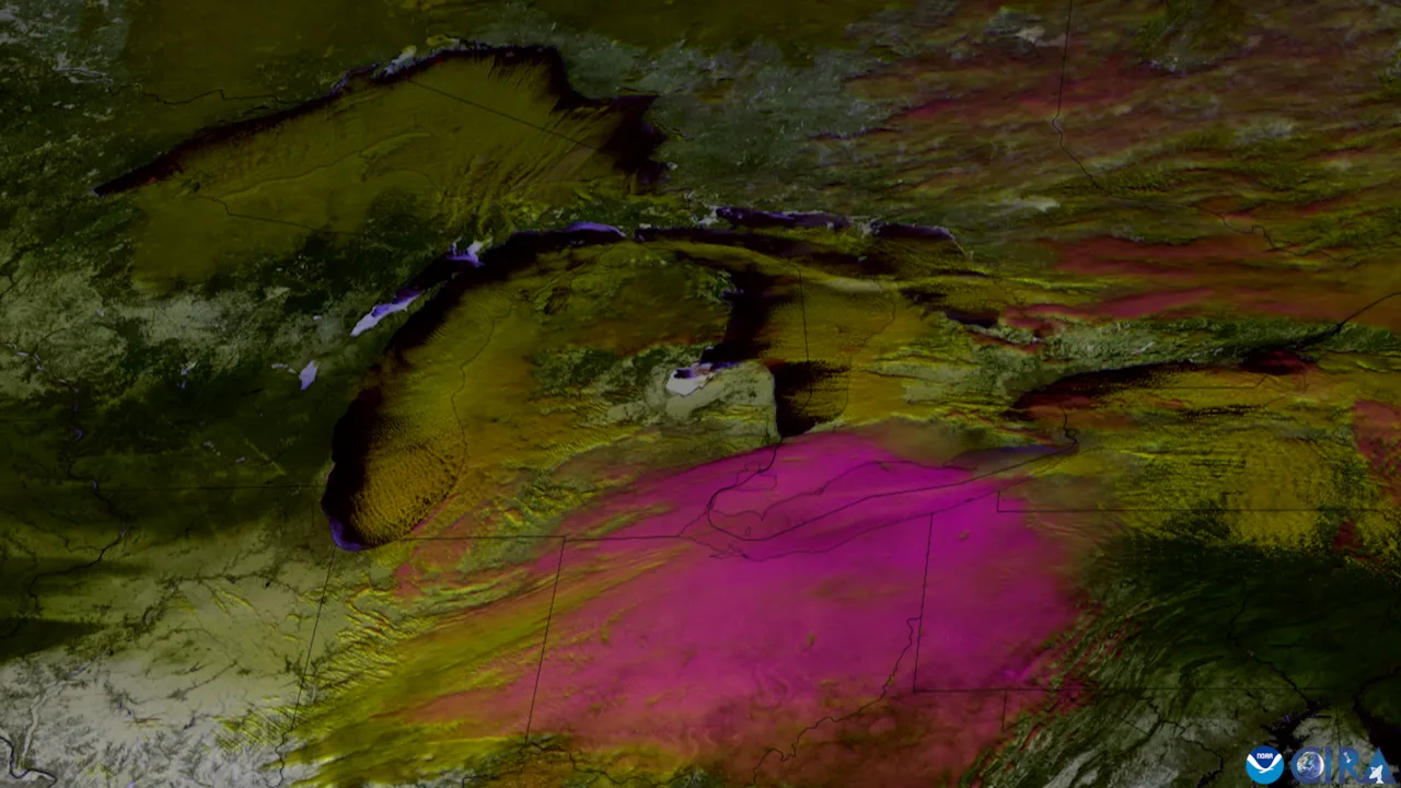
1. What two things meet to build giant clouds of lake-effect snow?
2. Where does all that lake-effect snow pile up the deepest?
🤯 Mind-Blowing Fact • Grade 2
New York's Tug Hill Plateau east of Lake Ontario averages over 200 inches—nearly 17 feet—of snow every single winter!
✨ Word Sparks (Grade 2 Glossary)
Tap 🔊 to hear
Great Lakes
five huge freshwater lakes in North America
Arctic air
bitterly cold air blowing down from far north
downwind
in the direction the wind is blowing toward
🪝
Why does lake-effect snow often stop in February even though winter is still freezing cold?
1
A Giant Snow Machine
Look at a winter satellite picture of North America's five , and you might spot long white stripes of cloud streaming off the water like smoke! Those stripes are lake-effect snowstorms in action.
2
Warm Water, Frigid Air
Big lakes hold onto summer warmth much longer than soil and rock do. In November and December, lake water may still be 40 degrees Fahrenheit when 10-degree Arctic wind roars overhead! Heat and water vapor bubble rapidly into the sky, freezing into narrow ribbons of snow.
3
Ice Shuts Off the Tap
If bitter January cold freezes a solid lid of ice across the lake, wind can no longer scoop up water vapor, and the snow machine shuts off!
1. Why are November and December prime months for big lake-effect snowstorms?
2. What happens to lake-effect snow if a lake freezes completely over with thick ice?
🤯 Mind-Blowing Fact • Grade 3
In November 2022, a single Lake Erie snowband dumped more than six and a half feet (80 inches) of snow south of Buffalo in just three days!
✨ Word Sparks (Grade 3 Glossary)
Tap 🔊 to hear
fetch
distance wind blows across open lake water
snowbelt
lakeshore region famous for heavy lake-effect snow
thundersnow
a winter snowstorm with lightning and thunder
🪝
Why does Buffalo, New York, get pounded by far more lake-effect snow than Chicago across the water?
1
Which Side of the Lake Are You On?
Check a map of the Great Lakes! Winter winds across North America usually blow from the northwest or southwest. That puts cities on eastern and southeastern shores—like Buffalo and Watertown in New York, Erie in Pennsylvania, and Marquette in Michigan—right in the bull's-eye of the ',' while western shores get far less!
2
Long Fetch Equals Deeper Snow
Meteorologists measure ''—the distance cold wind travels across open water. When frigid wind blows straight down the 240-mile length of Lake Erie toward Buffalo, air spends hours soaking up heat and moisture, building a single intense snowband!
3
Braking at the Shoreline
Water is smooth, so wind skims fast across the lake. Hitting rough land trees and hills acts like slamming on the brakes: air piles up, shoots upward, and wrings out 2 to 5 inches of snow per hour!
4
Thundersnow Surprises
Sometimes lake-driven updrafts surge so fast that lightning flashes right through blinding snow—creating booming winter !
1. Why does wind blowing lengthwise down long Lake Erie make heavier snow than wind crossing the narrow way?
2. What happens when fast lake wind suddenly hits rougher land and hills on the downwind shore?
🤯 Mind-Blowing Fact • Grade 4
Siberian winds crossing the Sea of Japan create colossal 'sea-effect' snowstorms that give Aomori City, Japan, over 25 feet of snow per year—making it Earth's snowiest major city!
✨ Word Sparks (Grade 4 Glossary)
Tap 🔊 to hear
convergence
winds coming together and forcing air upward
cloud streets
long parallel rows of convective snow clouds
snow ratio
inches of snow produced per inch of water
🪝
What exact temperature gap do weather forecasters look for before issuing a Lake-Effect Snow Warning?
1
The Thirteen-Degree Rule
Before posting a Lake-Effect Snow Warning, National Weather Service meteorologists check one critical number: the temperature difference between the lake's water surface and the air roughly 1.5 kilometers (5,000 feet) overhead! Whenever that vertical drop reaches at least 13 degrees Celsius (about 23 degrees Fahrenheit)—for instance, +5°C lake water beneath -10°C upper air—the lower atmosphere becomes fiercely unstable, launching buoyant plumes of steam and cloud droplets skyward.
2
Wind-Parallel Rolls vs. Shore-Parallel Bands
Wind direction sculpts two distinct styles of lake-effect storms. When Arctic wind blows across the short width of a lake like Lake Michigan, dozens of thin, parallel form, spreading moderate snow across many towns. When winds align straight down the long axis of Lake Erie or Lake Ontario (over 150 kilometers of fetch), converging land breezes focus all that energy into one narrow monster band just 15 to 30 kilometers wide!
3
Extra Fluffy Snow Ratios
Ordinary winter storms usually pack about 10 inches of snow from 1 inch of liquid water. Because lake-effect clouds often center right inside the -15°C dendritic growth zone, airy six-pointed star crystals stack loosely at 20-to-1 or even 30-to-1 ratios—piling waist-deep drifts with astonishing speed!
4
Global Cousins: Japan and Great Salt Lake
Lake-effect physics works beyond the Great Lakes too: Utah's salty Great Salt Lake fuels Wasatch Mountain powder, while Siberian gales crossing the Sea of Japan bury western Honshu in the deepest city snowpacks on Earth!
1. What minimum temperature drop between lake water and the air 1.5 km overhead triggers lake-effect instability?
2. Why does lake-effect snow pile up so many inches from relatively modest liquid water?
🤯 Mind-Blowing Fact • Grade 5
Lake Erie averages just 62 feet deep and often freezes shut by February, whereas 800-foot-deep Lake Ontario right next door stores so much heat that its lake-effect snow machine runs all winter long!
✨ Word Sparks (Grade 5 Glossary)
Tap 🔊 to hear
bathymetry
measurement of underwater depths in lakes or seas
sensible heat
warmth transferred directly from water to cold air
mesoscale
medium-sized weather systems spanning a few miles to hundreds
🪝
Why does shallow Lake Erie shut off its snow machine in mid-winter while deep Lake Ontario keeps roaring until spring?
1
Boundary-Layer Fluxes and Dry Adiabatic Lapse Rates
Watch winter satellite imagery as a continental Arctic air mass plunges across unfrozen Great Lakes water, and dramatic white convective plumes erupt right out of the dark water! Ferocious sensible and latent heat fluxes surge upward from the lake surface—often exceeding 500 to 1,000 watts per square meter. Forecasters compare lake surface temperature with the 850-hectopascal atmospheric level (~1,500 meters altitude): once that vertical drop exceeds 13 degrees Celsius—the dry adiabatic threshold—buoyant plumes punch 2 to 4 kilometers skyward until capped by a synoptic subsidence inversion.
2
Horizontal Roll Vortices vs. Single-Band Convergence
Minimal vertical wind shear (< 30 degrees directional shift through the convective layer) allows organized horizontal convective rolls to align with the wind. Short fetches (~80 kilometers across Lake Michigan) spawn multiple parallel snowbands, whereas long-axis fetches (> 250 kilometers down Lake Erie or Lake Ontario) allow thermally driven land breezes from cold opposing shores to converge along the lake's center line, focusing intense upward motion into a single 20-kilometer-wide snowband exceeding 10 centimeters per hour!
3
Frictional Convergence, Orography, and Dendritic Growth
Crossing from low-roughness water onto forested terrain abruptly increases surface friction, slowing onshore winds and forcing mass convergence right at the coast. Downwind plateaus—such as New York's 600-meter Tug Hill Plateau—add orographic lift that aligns peak supersaturation directly inside the -12°C to -18°C dendritic growth zone (DGZ), yielding feather-light snow-to-liquid ratios up to 35:1.
4
Bathymetry Controls Seasonal Shutdown
Lake depth governs each snowbelt's calendar! Because Lake Erie averages just 19 meters (62 feet) deep, winter cold often freezes 80 to 95 percent of its surface by late January, abruptly shutting off Buffalo's lake-effect season. Neighboring Lake Ontario plunges 244 meters (800 feet) deep, storing vast thermal inertia so it rarely freezes over and fuels Tug Hill blizzards into March!
5
Warming Winters and Ice-Cover Trends
Climatologists track a striking multi-decade trend: as regional winter temperatures warm and Great Lakes ice cover declines, mid-winter open water persists longer—temporarily boosting heavy lake-effect snow events before future springs shift more precipitation to rain.