🇺🇸 U.S. HISTORY
🏛️ U.S. Engineering & Infrastructure Milestone • Enacted June 29, 1956
VA History & Social Science SOL K.1, 1.2, 2.4, VS.1–VS.10, USI & USII
Interstate Highway System
How Red, White, and Blue Shields Connected All America
Grade 2 • Developing • 103 words
⏳ Era / StatehoodFederal-Aid Highway Act Signed June 29, 1956 by President Dwight D. Eisenhower
🗺️ Region / CapitalOver 48,000 Miles Linking All 48 Contiguous States (Plus Hawaii, Alaska & Puerto Rico Routes)
📜 Key MilestoneLargest public works engineering project in U.S. history; eliminated stoplights on cross-country routes
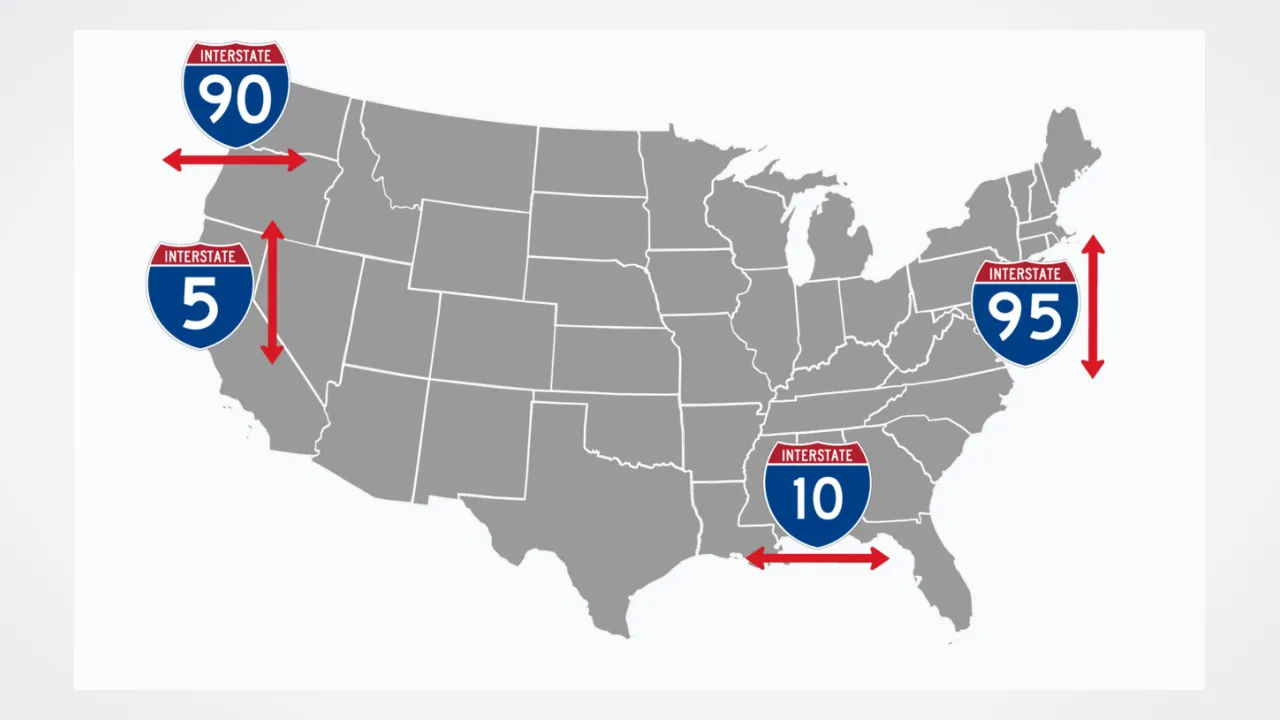
⚡ Historical SparkUses a clever math grid—odd numbers run North-to-South (like I-95) and even numbers run East-to-West (like I-64)!
🤯 Mind-Blowing Fact • Grade 1
On Interstate shield signs, odd numbers like I-95 go north and south, while even numbers like I-64 go east and west!
✨ Word Sparks (Grade 1 Glossary)
Tap 🔊 to hear
interstate
Connecting two or more states together
ramp
Sloped road helping cars merge smoothly
highway
Wide main road built for fast travel
🪝
How can a family car drive all the way across America without stopping at a single red traffic light?
1
Bumpy Mud Roads
Bump, splash, stuck! Long ago, dirt roads between towns turned to sticky mud whenever rain fell. Cross-country trips took weeks and weeks.
2
President Eisenhower's Big Idea
In 1956, President Dwight D. Eisenhower signed a law to build wide, smooth . Red, white, and blue shield signs showed drivers the way!
3
Bridges and Ramps
Curved and tall bridges replaced stoplights. Today, families and food trucks zoom safely from state to state every day!
1. Which U.S. President signed the 1956 law creating the Interstate Highway System?
2. Which direction do even-numbered Interstates like I-64 and I-80 travel?
🤯 Mind-Blowing Fact • Grade 2
Enough concrete was poured to build the Interstate Highway System to lay six wide sidewalks all the way from Earth to the Moon!
✨ Word Sparks (Grade 2 Glossary)
Tap 🔊 to hear
convoy
Group of trucks traveling together safely
median
Grassy strip separating opposite highway lanes
overpass
Bridge carrying one road safely above another
🪝
Why did a sixty-two-day muddy truck trip in 1919 inspire President Eisenhower to build superhighways?
1
Sixty-Two Days in the Mud
Picture young Army officer Dwight Eisenhower bouncing across dirt trails in 1919 with eighty-one military trucks! Driving from Washington, D.C. to San Francisco took sixty-two exhausting days because wooden bridges cracked and wheels sank axle-deep in prairie mud.
2
Signing the 1956 Highway Act
Years later, General Eisenhower saw wide multi-lane highways in Europe during World War II. As President in 1956, he signed the Federal-Aid Highway Act to build over forty-one thousand miles of safe, divided highways across America.
3
Secret Code in the Numbers
Engineers gave every Interstate a smart number code! Odd-numbered roads run north to south, even-numbered roads run east to west, and three-digit loops like I-495 circle cleanly around busy cities.
1. How long did young Dwight Eisenhower's 1919 Army truck trip from Washington, D.C. to California take?
2. What does a three-digit Interstate sign starting with an even number (like I-495 or I-664) usually do?
🤯 Mind-Blowing Fact • Grade 3
Wait—even Hawaii has official Interstate highways (H-1, H-2, and H-3) on the island of Oahu because 'Interstate' refers to federal highway funding and safety standards!
✨ Word Sparks (Grade 3 Glossary)
Tap 🔊 to hear
viaduct
Long bridge supported by series of towers
cloverleaf
Curved highway interchange shaped like four leaves
trust fund
Dedicated account saved strictly for road building
🪝
How did building 48,000 miles of stoplight-free highways change where Americans live, shop, and vacation?
1
Two Experiences Shape One Vision
Hear eighteen-wheelers humming smoothly across a mountain where stagecoaches once crept! President Dwight D. Eisenhower remembered two vivid lessons: his grueling 1919 cross-country truck convoy and seeing Germany's four-lane Reichsautobahn highways move vehicles swiftly at the end of World War II.
2
Engineering Controlled-Access Safety
Signed on June 29, 1956, the Federal-Aid Highway Act funded ninety percent of construction through a dedicated Highway paid by tiny fuel taxes. Every Interstate featured at least four lanes, wide grassy medians, gentle curves, ramps, and zero railroad crossings or traffic lights.
3
Decoding the Map Grid
Highway planners arranged numbers like a giant coordinate map! Lowest odd numbers start on the West Coast (I-5) and rise eastward to I-95 in Virginia and Maine, while lowest even numbers start in the South (I-10) and climb northward to I-90.
4
Linking Farms, Ports, and Families
Refrigerated trucks suddenly delivered fresh Florida oranges and Shenandoah Valley apples hundreds of miles overnight, while family road trips to national parks blossomed across the nation.
1. How did Congress pay for ninety percent of the Interstate Highway System without piling up huge debt?
2. Where is Interstate 95 located compared with Interstate 5?
🤯 Mind-Blowing Fact • Grade 4
Every overpass on rural stretches of the Interstate Highway System was engineered at least sixteen feet high so giant defense radar trailers—and even Saturn rocket stages—could roll safely underneath!
✨ Word Sparks (Grade 4 Glossary)
Tap 🔊 to hear
clearance
Safe open height beneath an overhead bridge
corridor
Major transportation route linking busy regions
logistics
Moving goods efficiently from farms to stores
🪝
Why was the Interstate System officially named a 'National System of Interstate and Defense Highways'?
1
Cold War Readiness and Everyday Safety
Imagine trying to move fifty million postwar family sedans and heavy freight trucks along narrow two-lane Main Streets! By 1955, traffic jams and dangerous head-on collisions plagued older U.S. highways, while Cold War planners worried narrow bridges could slow military supplies during emergencies. Signing the Federal-Aid Highway Act of 1956, President Eisenhower launched the largest civil engineering project in American history.
2
Uniform Standards From Coast to Coast
Federal engineers established strict nationwide rules: twelve-foot-wide lanes, ten-foot paved shoulders, bridge of at least sixteen feet so tall defense equipment could pass underneath, and controlled-access interchanges. Tunneling through Colorado's Continental Divide at the 11,000-foot Eisenhower Tunnel and bridging Chesapeake waterways pushed civil engineering to new heights.
3
Transforming Virginia's Economy
Across Virginia, key —I-95 linking Richmond and Northern Virginia, I-81 running down the Shenandoah Valley, I-64 connecting Hampton Roads ports to Charlottesville, and I-66 and I-495 serving the capital region—fueled booming hubs, tourism, and suburban growth.
4
Weighing Benefits and Urban Lessons
While Interstates cut highway crash rates per mile more than in half and slashed shipping costs, cutting wide freeways directly through historic city neighborhoods—such as Richmond's Jackson Ward—displaced thousands of residents, teaching modern planners to involve local communities carefully before building.
1. Why did engineers require at least sixteen feet of vertical clearance under Interstate highway bridges?
2. Which historic Richmond, Virginia neighborhood experienced disruption when Interstate 95/64 was routed through the city in the late 1950s?
🤯 Mind-Blowing Fact • Grade 5
Although Interstate highways make up barely 1% of all paved road miles in the United States, they carry roughly 25% of every mile Americans drive and nearly half of all heavy truck freight!
✨ Word Sparks (Grade 5 Glossary)
Tap 🔊 to hear
excise tax
Tax collected on specific goods like fuel
grade separation
Using bridges so crossing roads never collide
federalism
Partnership sharing duties between national and state governments
🪝
How did 48,000 miles of controlled-access concrete reshape American commerce, supply chains, and metropolitan geography?
1
From the 1919 Convoy to the Clay Committee
In July 1919, twenty-eight-year-old Lieutenant Colonel Dwight D. Eisenhower accompanied the U.S. Army's first Transcontinental Motor Convoy along the Lincoln Highway; eighty-eight wooden bridges collapsed under heavy trucks during the sixty-two-day trek. Three decades later, having witnessed rapid Allied troop movement on Germany's divided Autobahns in 1945, President Eisenhower appointed General Lucius D. Clay to design a self-financing national highway plan, culminating in the Federal-Aid Highway Act of June 29, 1956.
2
Pay-As-You-Go Federalism
Under Representative Hale Boggs and Senator Albert Gore Sr.'s financing compromise, the federal government covered ninety percent of construction costs via a Highway Trust Fund funded by motor-fuel and truck , while state departments of transportation owned, built, and maintained their segments. Uniform geometric standards—controlled access, , wide medians, and reflectorized green-and-white signage—reduced traffic fatalities per hundred million vehicle-miles by over sixty percent.
3
Mathematical Elegance of the Numbering Grid
Adopted by the American Association of State Highway Officials in 1957, the numbering system prevents confusion with older U.S. Highways (like U.S. Route 1 or Route 66, whose numbers grow from east to west and north to south). Interstate numbers intentionally ascend in the exact opposite directions—odd primaries from I-5 on the Pacific to I-95 on the Atlantic, and even primaries from I-10 along the Gulf/Southwest to I-90 across the northern tier—while three-digit spurs (odd first digit, like I-395) enter cities and beltways (even first digit, like I-495) encircle them.
4
Economic Transformation and Just-in-Time Supply Chains
Although Interstates represent roughly one percent of total U.S. road mileage, they carry approximately twenty-five percent of all vehicle travel and the vast majority of long-haul freight. Reliable transit times enabled 'just-in-time' manufacturing, decentralized industrial parks along Virginia's I-81 and I-95 corridors, and interconnected ports like Hampton Roads with inland markets.
5
Completing Glenwood Canyon and Looking Ahead
When Colorado finished a breathtaking twelve-mile elevated viaduct through scenic Glenwood Canyon on I-70 in 1992, the original forty-thousand-mile network stood essentially complete—leaving twenty-first-century engineers to modernize bridges, add transit lanes, and reconnect urban neighborhoods divided in the 1950s.