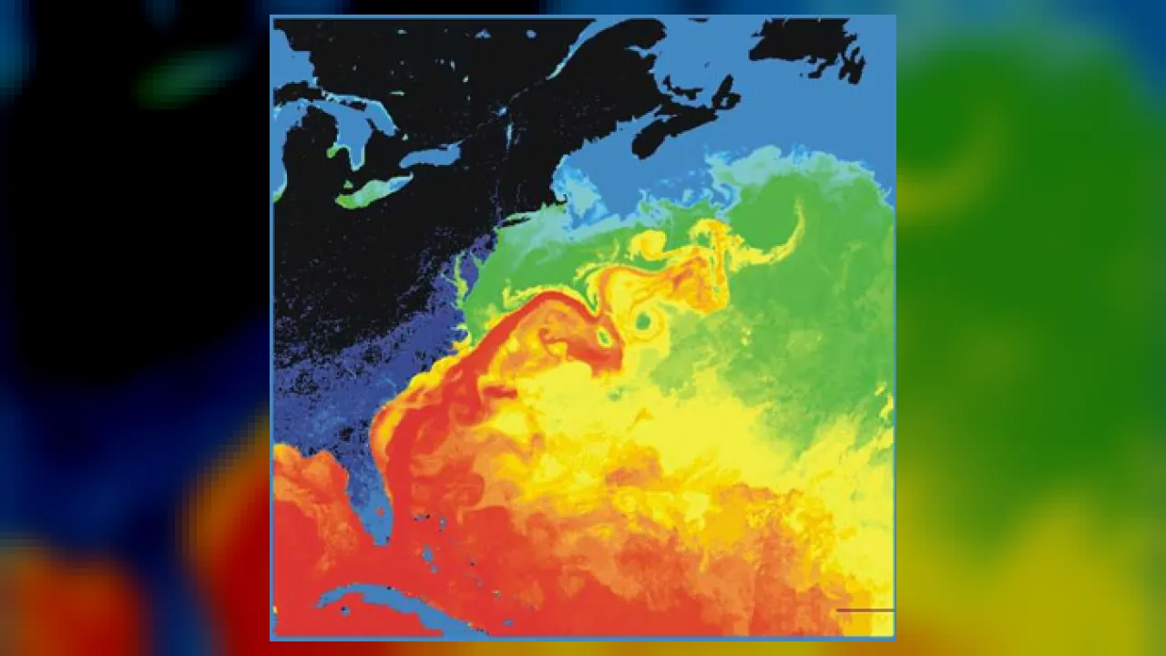
1. What kind of water does the Gulf Stream carry northward?
2. How do sea turtles use the Gulf Stream?
🤯 Mind-Blowing Fact • Grade 2
Thousands of rubber bath ducks accidentally spilled off a cargo ship in 1992 rode ocean currents around the world, helping scientists track how currents connect!
✨ Word Sparks (Grade 2 Glossary)
Tap 🔊 to hear
Thermometer
Tool used to measure how warm or cold
Equator
Warm imaginary line circling Earth's middle
Surface
Top layer of water touching the air
🪝
How did Benjamin Franklin map an invisible ocean highway using just a thermometer?
1
Ben Franklin's Mail Mystery
More than two hundred years ago, Benjamin Franklin wondered why mail ships sailing from England to America took two weeks longer than American whaleboats! Nantucket captains told him a secret: they steered around a fast eastward ocean river while British ships accidentally sailed right against it.
2
Measuring Warm Water
Franklin dipped into the Atlantic during ocean crossings and mapped warm water racing up from Florida and bending toward Europe. He published the first famous map of the Gulf Stream!
3
Warming Distant Lands
Winds and Earth's spin steer currents in big loops. Warm air rising off the Gulf Stream keeps winters in England and Ireland much milder than icy Canada!
1. How did Benjamin Franklin tell when his ship entered the Gulf Stream?
2. How does the Gulf Stream system affect winter weather in Western Europe?
🤯 Mind-Blowing Fact • Grade 3
Palm trees actually grow outdoors in coastal Scotland—at the same northern latitude as icy Labrador, Canada—thanks to heat carried northeast by the Gulf Stream!
✨ Word Sparks (Grade 3 Glossary)
Tap 🔊 to hear
Gyre
Giant circular loop of spinning ocean currents
Salinity
Amount of dissolved salt inside ocean water
Density
How heavy water is for its exact size
🪝
Why do giant ocean currents swirl clockwise in the north and counterclockwise in the south?
1
Wind and Spinning Gyres
Blow gently across a bowl of soup, and watch ripples swirl around the rim! Across Earth's oceans, steady global winds push the top layer of water. Because Earth spins on its axis, moving currents curve into giant circular loops called —spinning clockwise in the Northern Hemisphere and counterclockwise in the Southern Hemisphere.
2
Racing Up the East Coast
Forming the fast western edge of the North Atlantic , the Gulf Stream blasts out through the Straits of Florida at up to five miles per hour! Sweeping past Georgia, the Carolinas, and offshore Virginia, this fifty-mile-wide ribbon carries sun-warmed tropical water northeastward.
3
Deep Currents Driven by Salt and Cold
Wind only pushes the top few hundred meters of the sea. Deep below, cold and extra-salty polar water becomes heavy and dense, sinking to the ocean floor to creep slowly around the globe!
4
Earth's Thermostat
Together, warm surface currents and cold deep currents act like Earth's air conditioner and heater—carrying tropical warmth toward the poles and polar chill toward the equator.
1. Which way do giant ocean gyres spin in the Northern Hemisphere?
2. What makes polar ocean water dense enough to sink and start deep ocean currents?
🤯 Mind-Blowing Fact • Grade 4
A single drop of seawater riding the deep Global Ocean Conveyor Belt takes roughly one thousand years to complete one full lap through all of Earth's oceans!
✨ Word Sparks (Grade 4 Glossary)
Tap 🔊 to hear
Coriolis Effect
Curving of winds and currents by Earth's spin
Thermohaline
Deep ocean flow driven by temperature and salt
Conveyor Belt
Connected global loop of surface and deep currents
🪝
Why do thick fog banks roll across the Grand Banks where the warm Gulf Stream collides with a polar current?
1
Coriolis Curve and Coastal Climate
Sail fifty miles east of Cape Hatteras, North Carolina, and Virginia's offshore waters suddenly turn deep cobalt blue and jump ten degrees warmer! That crisp boundary marks the edge of the Gulf Stream. Global trade winds and westerlies push Atlantic surface water, while the —caused by Earth's eastward rotation—deflects moving water to the right in the Northern Hemisphere, tightening the Gulf Stream fast against North America's eastern continental slope.
2
Where Warm Meets Icy Cold
Off Newfoundland's Grand Banks, the warm northward Gulf Stream collides head-on with the frigid southward Labrador Current. Warm, humid air above the Gulf Stream chills instantly over the icy water, condensing into some of the thickest sea fog on Earth! Mixing currents also stir up rich nutrients, creating legendary fishing grounds while melting drifting icebergs.
3
The Global Ocean Conveyor Belt
Branching eastward as the North Atlantic Current toward Europe, Gulf Stream water eventually loses heat to crisp Arctic winds. Meanwhile, forming sea ice leaves dissolved salt behind in the liquid seawater. Cold and extra-salty, this dense water plunges miles down to the abyssal floor—powering circulation, or the Global !
4
Fueling Marine Life and Storms
Inside the North Atlantic Gyre sits the calm Sargasso Sea, where golden floating sargassum seaweed shelters baby loggerhead turtles from Virginia and Florida beaches—though meteorologists also watch the warm Gulf Stream carefully because passing hurricanes can draw extra energy from its heat.
1. What happens off Newfoundland where the warm Gulf Stream meets the icy Labrador Current?
2. Why does freezing sea ice near Greenland actually make the leftover liquid seawater beneath it sink?
🤯 Mind-Blowing Fact • Grade 5
Offshore of Virginia and New England, the meandering Gulf Stream swells to carry up to 150 sverdrups—equivalent to 150 million cubic meters of seawater rushing past every single second!
✨ Word Sparks (Grade 5 Glossary)
Tap 🔊 to hear
Sverdrup
Unit equal to one million cubic meters per second
Brine Rejection
Freezing sea ice pushing extra salt into seawater
Warm-Core Ring
Spinning warm eddy pinched off from Gulf Stream
🪝
Why is the Gulf Stream narrow, deep, and jet-fast on the western side of the Atlantic while Europe's Canary Current is wide and slow?
1
Western Boundary Intensification and Sverdrups
Measure ocean flow with satellite radar altimeters and underwater gliders, and a striking asymmetry leaps off every global map: currents hugging the western sides of ocean basins—like the Atlantic's Gulf Stream and the Pacific's Kuroshio Current—race poleward in narrow, deep jets up to two meters per second, whereas eastern boundary currents like the California and Canary currents drift equatorward in wide, lazy sheets. Oceanographer Henry Stommel explained this 'western boundary intensification' in 1948: because the Coriolis parameter strengthens with latitude from equator to pole, vorticity balance squeezes gyre return flow tightly against western continental margins!
2
Measuring Transport in Sverdrups
Oceanographers measure massive current volume in (Sv), where one sverdrup equals one million cubic meters (roughly 264 million gallons) of water flowing past a point every second! Passing between Florida and the Bahamas at roughly 30 Sv, the Gulf Stream entrains recirculating Sargasso gyre water as it passes Cape Hatteras and offshore Virginia, swelling to an astonishing 100 to 150 sverdrups—nearly one hundred times the combined discharge of every river on land.
3
Warm-Core and Cold-Core Mesoscale Rings
Like a meandering river on land, the fast Gulf Stream develops giant wave-like loops after leaving the continental slope off North Carolina and Virginia. When a loop pinches off into a spinning vortex 100 to 300 kilometers wide, loops pinching northward trap tropical water inside clockwise , while loops pinching southward trap cold slope water inside counterclockwise cold-core rings!
4
AMOC and Brine Rejection Engines
Poleward heat transport—peaking above one petawatt (a quadrillion watts) in the North Atlantic—feeds the Atlantic Meridional Overturning Circulation (AMOC). In the Greenland, Iceland, and Norwegian seas, evaporative cooling and sea-ice create dense North Atlantic Deep Water (NADW), which plunges two to four kilometers deep and flows southward all the way toward Antarctica.
5
Monitoring Climate Stability With Moorings
Because massive influxes of fresh Greenland meltwater could dilute North Atlantic surface salinity and slow deep-water sinking, international sensor arrays like RAPID at 26.5°N continuously monitor Gulf Stream and AMOC strength to safeguard climate forecasts.