1. Which north stays fixed at the exact top of Earth's spin?
2. What does a compass needle actually point toward?
🤯 Mind-Blowing Fact • Grade 2
Over the last hundred years, Magnetic North has traveled more than 600 miles northward out of northern Canada into the middle of the icy Arctic Ocean!
✨ Word Sparks (Grade 2 Glossary)
Tap 🔊 to hear
Axis
Imaginary center line Earth spins around
Magnetic North
Arctic spot where compass needles point
Navigate
To find your way from place to place
🪝
Why could following a compass straight ahead make an Arctic explorer miss the North Pole by hundreds of miles?
1
Map North vs. Magnet North
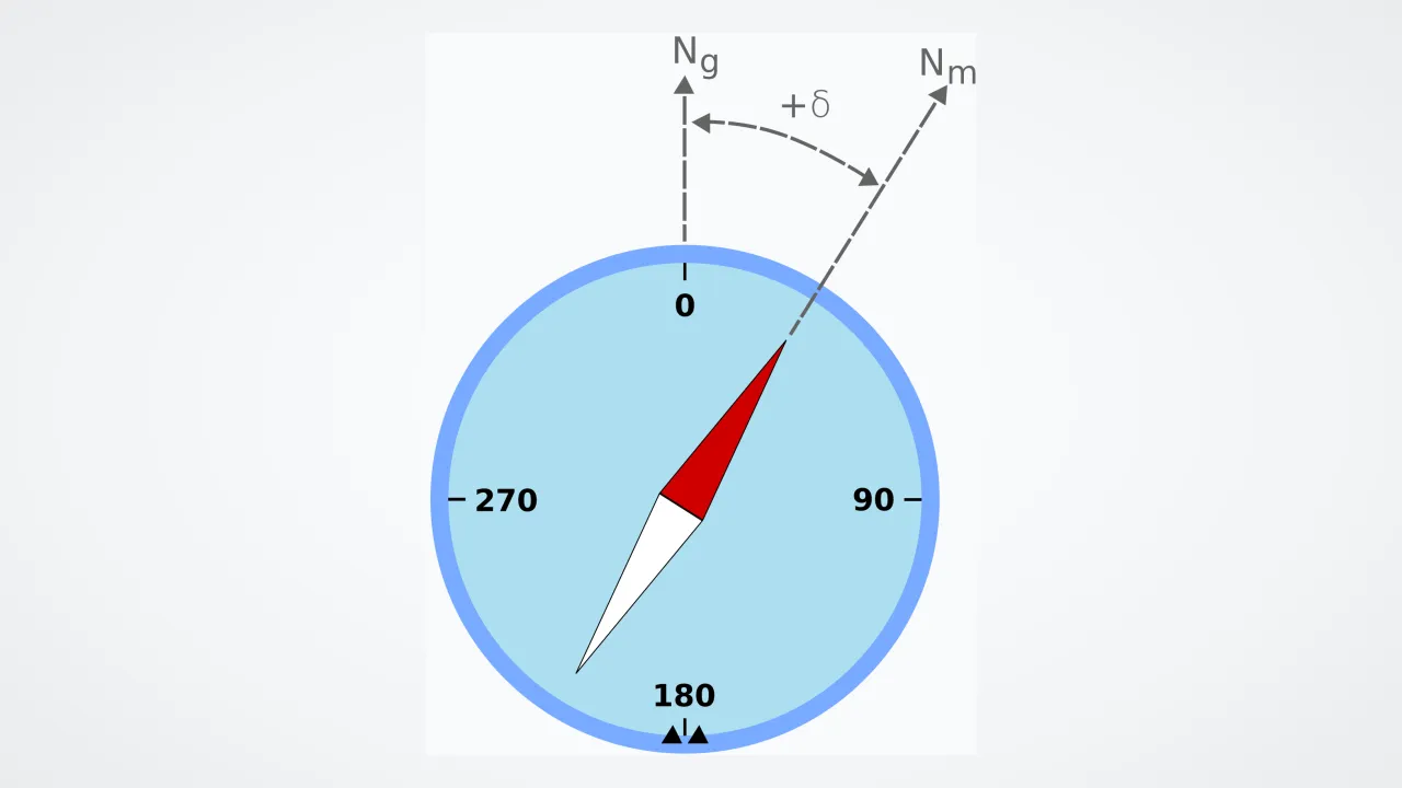
Open a paper trail map, and the top edge points straight to True North—the exact icy spot where all north-south globe lines meet. Now hold a pocket compass beside that map, and surprise: the needle points slightly off to one side!
2
Why They Don't Match
True North is set by how Earth spins like a toy top, and the bright North Star shines almost directly above it. Compass North—also called —is pulled by hot liquid iron swirling deep inside Earth's core.
3
Smart Map Adjustments
Because liquid iron never stops sloshing underground, slowly drifts from Canada toward Siberia. Hikers check a tiny arrow printed in the corner of their map so they can turn a few degrees and walk straight on course!
1. Which star shines almost right above True North in the night sky?
2. Why does Magnetic North move a little bit every year?
🤯 Mind-Blowing Fact • Grade 3
Airport runways are numbered by their magnetic compass heading—so when Magnetic North drifts far enough, airports actually have to repaint huge new numbers onto their concrete runways!
✨ Word Sparks (Grade 3 Glossary)
Tap 🔊 to hear
Declination
Angle difference between True and Magnetic North
Geographic Pole
Fixed point where Earth's spin axis meets surface
Heading
Compass direction a traveler or plane faces
🪝
What secret angle printed at the bottom of a hiking map keeps scouts from walking into the wrong valley?
1
A Tale of Two Poles
Imagine standing on a misty trail in Shenandoah National Park with a paper map and a compass. Every north-south line on your map aims at Geographic North—90 degrees north latitude, where Earth's axis pokes through the Arctic sea ice. Your magnetized compass needle, however, follows invisible magnetic field lines toward Magnetic North hundreds of miles away!
2
Meet Magnetic Declination
Navigators call the angle between True North and Compass North 'magnetic .' In Virginia, a compass needle points about ten degrees west of True North, while in Washington State it points about fifteen degrees east of True North!
3
Even a Small Angle Matters
Being off by ten degrees sounds tiny in your backyard, yet over a ten-mile hike or flight it puts you nearly two miles sideways from camp!
4
Updating World Maps
Because churning core currents move Magnetic North up to thirty miles a year, geophysicists update the World Magnetic Model every five years for ships, airplanes, and smartphones.
1. What do mapmakers call the angle between True North and Magnetic North?
2. Why do airports occasionally have to repaint the big numbers on their runways?
🤯 Mind-Blowing Fact • Grade 4
Here is a wild physics twist: because opposite magnetic poles attract, the 'north-seeking' end of your compass needle is actually pulled toward a south-type magnetic pole located in Earth's Arctic!
✨ Word Sparks (Grade 4 Glossary)
Tap 🔊 to hear
Agonic Line
Map line where True and Magnetic North align
Magnetometer
Electronic sensor measuring magnetic field direction
Cartographer
Specialist who designs accurate geographic maps
🪝
Why does a compass point dead-on toward True North along the Mississippi River while pointing noticeably crooked in Maine and Oregon?
1
Rotational Geometry vs. Core Fluid Dynamics
Place a spinning top beside a sloshing bowl of soup, and you can picture why True North and Compass North rarely match. Geographic True North marks the northern intersection of Earth's rotational axis with the surface—anchored steadily beneath Polaris at 90 degrees north latitude. Magnetic North, by contrast, marks the spot in the high Arctic where geomagnetic field lines plunge vertically downward into the crust.
2
The Agonic Line Across America
If you stand along a curving path running roughly through Wisconsin, Illinois, Louisiana, and the Gulf of Mexico, Magnetic North happens to line up directly behind or in front of True North! call that zero-degree-declination path the . Travel east to Virginia or Maine, and Magnetic North lies slightly to the left of True North (west declination); travel west to California or Oregon, and Magnetic North lies to the right (east declination).
3
Why Compass Needles Dip Near the Pole
Near the Magnetic North Pole itself, field lines dive straight downward at ninety degrees. An ordinary compass needle tries to point into the snow, dragging against its case and spinning sluggishly!
4
Combining GPS and Magnetic Sensors
Wait—if phones use GPS satellites, do compasses still matter? Yes! GPS tracks where you are moving, while built-in plus the World Magnetic Model tell which direction you are facing when standing still.
1. What happens to a compass reading if you stand right on the agonic line in the central United States?
2. Why does a flat pocket compass struggle to work right on top of the Magnetic North Pole?
🤯 Mind-Blowing Fact • Grade 5
Earth's North and South Magnetic Dip Poles aren't even exact opposites across the globe—because core currents are uneven, the South Magnetic Pole actually sits offshore in the ocean outside Antarctica's coast!
✨ Word Sparks (Grade 5 Glossary)
Tap 🔊 to hear
Azimuth
Horizontal direction measured clockwise in degrees
Inclination
Downward dip angle of magnetic field lines
Grid North
North direction along flat map grid lines
🪝
How did eleventh-century scholar Shen Kuo discover magnetic declination four hundred years before European ocean navigators noticed it?
1
Shen Kuo's Silk-Thread Discovery
Around 1088 CE, Chinese polymath Shen Kuo suspended a magnetized steel needle from a single strand of silk wax inside a windless room and recorded a groundbreaking observation in his Dream Pool Essays: the needle consistently pointed slightly east of true meridian south-north! Four centuries later, Christopher Columbus noticed compasses shifting from east to west declination across the Atlantic, alerting mariners worldwide that magnetic and geographic meridians diverge.
2
Three Norths on Precision Maps
Modern US Geological Survey (USGS) quadrangle maps actually display a three-pronged diagram at the margin: True North (marked with a star for Polaris), Magnetic North (marked MN), and (marked GN, showing slight geometric distortion from flattening curved meridians onto rectangular Universal Transverse Mercator map sheets). Backcountry navigators add or subtract local declination so map bearings and field match.
3
Tug-of-War Between Core Flux Lobes
When British explorer James Clark Ross first reached the North Magnetic Dip Pole on Canada's Boothia Peninsula in 1831, it crept at barely 10 to 15 kilometers per year. After 1990, shifting liquid-iron jet streams beneath Canada and Siberia altered two deep magnetic flux lobes at the core-mantle boundary, accelerating the pole past 55 kilometers per year across the international date line corridor before moderating near 40 km/yr.
4
Inclination, Dip Poles, and Geomagnetic Poles
Geophysicists also distinguish between the wandering 'magnetic dip pole'—where local reaches 90 degrees vertically—and the 'geomagnetic pole,' where a best-fit tilted bar-magnet axis (tilted ~9.4 degrees from Earth's spin axis) intersects the globe, because Earth's outer-core field isn't a pure dipole.
5
Global Navigation Infrastructure
Every five years, NOAA and the British Geological Survey assimilate Swarm satellite data to publish an updated World Magnetic Model, ensuring submarine inertial systems, aviation autopilots, directional oil-well drills, and smartphone digital compasses translate magnetic readings seamlessly into true geographic headings.