🌋 Where It FormsTroposphere From Sea Level to Mountain Summits
💎 Key PropertiesAverage Sea-Level Pressure: 1013.25 mb (29.92 inHg) • High (H) vs. Low (L)
⚡ Planet Earth SparkReveals whether invisible columns of air are sinking for clear skies or rising to build clouds and storms
🤯 Mind-Blowing Fact • Grade 1
The column of air resting above a small school desk weighs about as much as a small truck—yet air inside the room pushes up equally so the desk never breaks!
✨ Word Sparks (Grade 1 Glossary)
Tap 🔊 to hear
pressure
Steady push against a surface
barometer
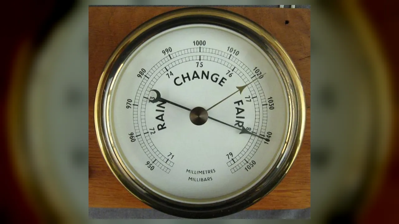
Tool that measures air pressure changes
predict
Tell what will likely happen next
🪝
Did you know the invisible air above your head actually has weight?
1
Air Pushes All Around
Take a deep breath of fresh air! Even though air looks empty, miles of air above us gently push down. Weather helpers call that push barometric !
2
Happy Highs, Rainy Lows
On a TV weather map, a big blue H means high and sunny skies! A big red L means low pressure with clouds and rain.
3
A Clever Weather Tool
Scientists use a dial tool called a to watch air change. Falling pressure warns us to grab an umbrella!
1. What kind of weather does a big blue 'H' (high pressure) usually bring?
2. Which weather instrument measures barometric pressure?
🤯 Mind-Blowing Fact • Grade 2
A sealed bag of potato chips packed at sea level puffs up tight like a pillow when you carry it up a high mountain because outside air pressure is lower!
✨ Word Sparks (Grade 2 Glossary)
Tap 🔊 to hear
altitude
Height above sea level
system
Connected weather pattern moving across maps
vapor
Invisible water gas floating in air
🪝
Why do your ears pop when you ride up a tall mountain or take off in an airplane?
1
Popping Ears Show Air Weight
Pop! Ride up a steep mountain highway or climb inside an airplane, and your ears feel a funny tickle. Less air sits above you high up than down at the beach, so barometric pressure drops as you climb!
2
Why Highs Are Clear
Even at the same town level, air pressure changes day by day. Inside a High-pressure (H), cool, heavy air sinks toward the ground, warming up and drying out clouds so the sun shines brightly.
3
Why Lows Bring Storms
Inside a Low-pressure (L), warm, moist air rises upward like an invisible chimney. Rising air cools off and turns water into rain clouds or winter snow!
1. Why does a Low-pressure system (L) usually create cloudy or rainy weather?
2. What happens to barometric pressure as a hiker climbs from sea level up a tall mountain?
🤯 Mind-Blowing Fact • Grade 3
Evangelista Torricelli poetically wrote in 1644, 'We live submerged at the bottom of an ocean of the element air!'
✨ Word Sparks (Grade 3 Glossary)
Tap 🔊 to hear
atmosphere
Blanket of gases surrounding planet Earth
aneroid
Barometer using a metal box, not liquid
trend
Direction a measurement changes over time
🪝
How did an Italian scientist in 1643 prove we live at the bottom of a deep 'ocean of air'?
1
Torricelli's Clever Glass Tube
In 1643, Italian physicist Evangelista Torricelli filled a three-foot glass tube with heavy liquid mercury and flipped its open end into a dish. Instead of draining out completely, nearly thirty inches of mercury stayed pushed up inside the tube! Torricelli realized the invisible weight of Earth's pressing on the dish held it up—inventing the world's first barometer.
2
How Wind Flows Between H and L
Air always tries to move from High pressure toward Low pressure, just like air rushing out of an untied balloon! When High and Low centers sit close together with big pressure differences, winds blow strong and gusty.
3
Aneroid Barometers Without Liquid
Most classroom and home barometers today are safe ('without liquid') barometers. Inside sits a hollow metal capsule that squeezes slightly inward when air pressure rises and expands when pressure falls, moving a pointer needle.
4
Reading the Trend
Steady rising pressure signals clearing skies ahead, while rapidly falling pressure warns of an approaching storm!
2. If you tap your classroom barometer and see the needle dropping quickly, what weather is likely on the way?
🤯 Mind-Blowing Fact • Grade 4
Right hand trick: make a thumbs-up with your right hand for rising air in a Northern Hemisphere Low—your fingers curl counterclockwise just like the storm's winds!
✨ Word Sparks (Grade 4 Glossary)
Tap 🔊 to hear
millibar
Metric unit meteorologists use for pressure
isobar
Weather map line of equal pressure
cyclone
Rotating weather system around low pressure
🪝
Which way do winds swirl around Highs and Lows on a North American weather map—and why?
1
Measuring Millibars and Inches
At sea level, Earth's atmosphere presses on every square inch with 14.7 pounds of force! Virginia SOL students and television meteorologists track this weight using two common units: inches of mercury (averaging 29.92 inHg) and metric or hectopascals (averaging 1013.25 mb). Strong sunny Highs can top 1040 millibars, whereas fierce Atlantic hurricanes can plunge below 940 millibars!
2
Clockwise Highs, Counterclockwise Lows
Because Earth spins beneath moving air, winds in the Northern Hemisphere do not blow in straight lines from H to L. Around a High-pressure anticyclone, sinking air spreads outward and curves right—spinning CLOCKWISE like the hands of a clock. Around a Low-pressure , surface air spirals inward and curves COUNTERCLOCKWISE, crowding together at the center where it has nowhere to go except straight up!
3
Decoding Isobar Lines
Forecasters connect cities reporting equal sea-level air pressure with smooth curved loops called . Widely spaced isobars signal gentle breezes; tightly packed isobars warn of howling gales!
4
Barometers Inside Your Pocket
Modern smartphones and smartwatches actually carry microscopic silicon barometers on computer chips—helping GPS apps tell which building floor you are standing on AND feeding millions of pressure readings to weather models!
1. In North America (Northern Hemisphere), how does surface air move around a Low-pressure (L) center?
2. What do closely packed isobar lines on a weather map tell a meteorologist?
🤯 Mind-Blowing Fact • Grade 5
Molecule for molecule, humid air is actually LIGHTER than dry air because a water molecule ($H_2O$, weight 18) weighs much less than nitrogen ($N_2$, weight 28) or oxygen ($O_2$, weight 32)!
✨ Word Sparks (Grade 5 Glossary)
Tap 🔊 to hear
hydrostatic
Fluid pressure caused by weight overhead
subsidence
Slow sinking motion of atmospheric air
compressible
Able to be squeezed closer together
🪝
Why must a weather station in mile-high Denver adjust its barometer reading before drawing a national weather map?
1
Hydrostatic Balance and Sea-Level Reduction
Atmospheric pressure at any altitude equals the gravitational weight per unit area of the gas column overhead ($P = \int \rho g\,dz$), averaging $101{,}325$ pascals ($1013.25$ hectopascals or millibars) at mean sea level. Because air is , pressure drops exponentially with height—falling roughly 1 hectopascal every 8 meters near sea level! Consequently, mile-high Denver, Colorado (elevation 1,609 meters), always records raw station pressure near 835 hPa even on blazing sunny afternoons. If meteorologists plotted raw pressures directly, Denver would look like a permanent Category 5 hurricane! Instead, stations mathematically adjust readings to 'mean sea-level pressure' before drawing synoptic isobars.
2
Why Humid Air Is Actually Lighter Than Dry Air!
Many people assume muggy, humid air is 'heavier' than dry air, yet Avogadro's gas law proves the exact opposite! Dry air consists mostly of diatomic nitrogen ($\text{N}_2$, molecular mass 28) and oxygen ($\text{O}_2$, molecular mass 32). When lighter water-vapor molecules ($\text{H}_2\text{O}$, molecular mass 18) replace nitrogen and oxygen at equal temperature and volume, the air parcel becomes LESS dense, rises buoyantly, and helps lower surface barometric pressure.
3
Friction, Convergence, and Bombogenesis
Aloft, winds blow parallel to isobars in geostrophic balance. Near the ground, surface friction slows the wind, weakening Coriolis deflection so air crosses isobars at a 15-to-30-degree angle inward toward Low centers (forcing upward convection) and outward from High centers (forcing clear ). When central pressure plunges at least 24 hPa in 24 hours at $60^{\circ}$ latitude, meteorologists classify the rapidly intensifying storm as explosive cyclogenesis—a 'bomb cyclone.'
4
World Record Extremes
Earth's highest sea-level-adjusted pressure reached 1084.8 hPa in frigid Mongolia in 2001, while Super Typhoon Tip set the lowest sea-level record at 870 hPa in the western Pacific in October 1979.
5
MEMS Micro-Barometers in Modern Forecasting
Today, micro-electromechanical systems (MEMS) capacitive pressure sensors etched onto silicon wafers equip weather balloons, ocean buoys, aircraft altimeters, and billions of mobile devices.