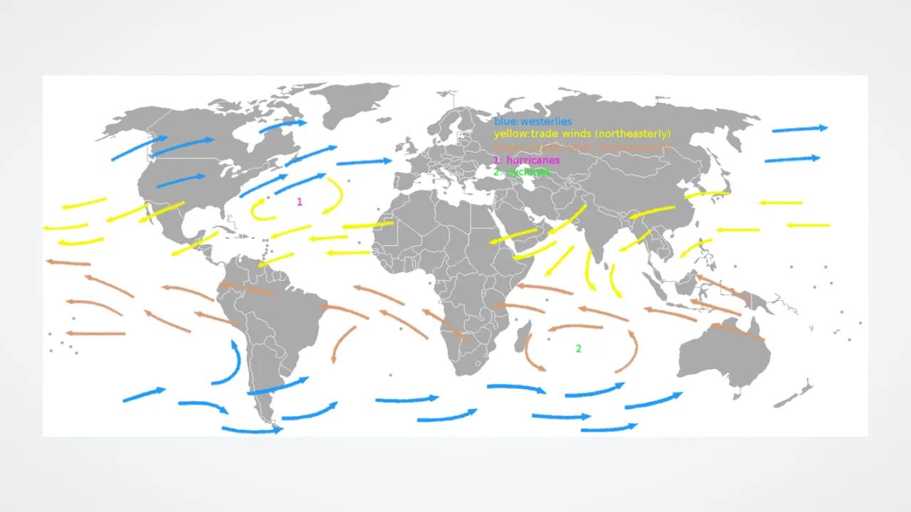
1. Which general direction do the trade winds blow across tropical oceans?
2. How did trade winds help wooden sailing ships long ago?
🤯 Mind-Blowing Fact • Grade 2
In Hawaii, steady northeast trade winds blow on roughly eight out of every ten summer days!
✨ Word Sparks (Grade 2 Glossary)
Tap 🔊 to hear
reliable
Dependable enough to count on every time
equator
Imaginary circle around Earth's warmest middle
volcanic
Formed by melted rock from volcanoes
🪝
Why does the word 'trade' in trade winds originally mean 'staying on track'?
1
A Reliable Ocean Highway
Imagine steering a tall wooden sailing ship across three thousand miles of open ocean. Centuries ago, captains discovered broad belts of gentle wind that blew steadily toward the west almost every day. Because 'blowing trade' meant blowing along a regular track, ships followed them across the seas!
2
Sun Plus Spin
Strong sunshine heats the all year long, making warm tropical air rise high into the sky. Cooler air from north and south glides inward along the ocean to replace it, and Earth's spin curves both breezes westward.
3
Shaping Island Weather
When moist trade winds bump into Hawaii's mountains, they drop lush rain on the eastern side while leaving western beaches sunny and dry!
1. What starts the giant air loop that creates Earth's trade winds?
2. Why is the eastern side of a Hawaiian mountain usually greener and rainier than the western side?
🤯 Mind-Blowing Fact • Grade 3
Sailors nicknamed the calm belt right along the equator the 'Doldrums' because wooden ships could sit stranded with slack sails for weeks waiting for a breeze!
✨ Word Sparks (Grade 3 Glossary)
Tap 🔊 to hear
latitude
Distance north or south of Earth's equator
converge
Come together and meet from different sides
doldrums
Calm ocean belt near the equator
🪝
What happens in the 'Doldrums' right where the northern and southern trade winds meet?
1
Two Matching Wind Belts
Spin a classroom globe and find the warm belt between thirty degrees north and thirty degrees south . North of the equator, the Northeast Trade Winds blow from the northeast toward the southwest. South of the equator, the Southeast Trade Winds blow from the southeast toward the northwest. Meteorologists name winds after the direction they come FROM!
2
The Hadley Cell Loop
Both wind belts belong to a giant atmospheric loop called the Hadley cell. Hot, humid air rises near the equator, flows toward the poles high overhead, sinks around thirty degrees , and returns equatorward across the sea as steady fifteen-mile-per-hour trade winds.
3
Horse Latitudes and Doldrums
Sailors feared two calm zones bordering the trade winds! Near thirty degrees—the 'Horse '—sinking air leaves waters windless. Right along the equator—the ''—converging trade winds rise straight upward, leaving sails limp between sudden downpours.
4
Steering Tropical Storms
During summer and fall, Atlantic trade winds also steer young tropical waves westward from Africa toward the Caribbean Sea.
1. Why are winds blowing from the northeast toward the southwest called 'Northeast Trade Winds'?
2. Why did wooden sailing ships sometimes get stuck in the equatorial 'Doldrums'?
🤯 Mind-Blowing Fact • Grade 4
Colonial sailing captains could not sail straight east against the trade winds—they had to loop north past Bermuda to catch west-to-east winds home to Europe!
✨ Word Sparks (Grade 4 Glossary)
Tap 🔊 to hear
prevailing
Most common wind direction in a region
westerlies
Mid-latitude winds blowing west to east
subtropical
Warm zones just outside the tropics
🪝
How did ocean navigators return eastward to Europe if the trade winds always blew them west?
1
Solving the Round-Trip Ocean Puzzle
During the 1400s and 1500s, Portuguese and Spanish navigators mastered a clever ocean secret called the volta do mar—'turn of the sea.' Sailing south past the Canary Islands, captains caught the steady Northeast Trade Winds westward across the Atlantic to the Caribbean. Trying to sail straight back into those same headwinds was nearly impossible! Instead, ships steered north past Virginia and Bermuda beyond thirty degrees latitude to ride the back home to Europe.
2
Hadley Cells and Coriolis Turning
English lawyer and amateur meteorologist George Hadley explained why in 1735. Sinking air beneath high-pressure belts at 30°N and 30°S flows across the ocean back toward low pressure at the equator. Because Earth rotates eastward beneath that moving air, the Coriolis effect deflects Northern Hemisphere air to the right (creating northeast trades) and Southern Hemisphere air to the left (creating southeast trades).
3
Driving Ocean Gyres and Saharan Dust
Day after day, friction from the trade winds pushes warm surface water westward—forming the North and South Equatorial Currents—and carries plumes of nutrient-rich Saharan dust thousands of miles from Africa to South America.
4
Hurricane Highway
Forecasters at the National Hurricane Center closely watch Atlantic trade-wind speed, because brisk trades stir cool ocean water upward while gentler trades let tropical disturbances organize into hurricanes.
1. How did sailing ships travel back east from the Americas to Europe?
2. Who proposed in 1735 that rising equatorial heat plus Earth's spin creates the trade winds?
🤯 Mind-Blowing Fact • Grade 5
Mount Waialeale on Kauai intercepts moist Pacific trade winds so efficiently that it averages around 450 inches (over thirty-seven feet) of rain a year, yet sunny beaches fifteen miles downwind get less than twenty inches!
✨ Word Sparks (Grade 5 Glossary)
Tap 🔊 to hear
inversion
Warm air layer sitting atop cooler air
anticyclone
Large weather system of sinking high pressure
leeward
Downwind side sheltered behind a mountain
🪝
Why does an invisible temperature lid called the trade-wind inversion cap tropical clouds like a ceiling?
1
Dynamics of the Lower Hadley Branch
Covering nearly half of Earth's surface area between 30°N and 30°S, the trade winds form the persistent surface return branch of the tropical Hadley circulation. Semi-permanent subtropical —such as the Azores-Bermuda High in the North Atlantic and the North Pacific High near Hawaii—export subsiding dry air equatorward toward the low-pressure trough of the Intertropical Convergence Zone (ITCZ). Deflected westward by planetary rotation, these easterlies average 5 to 8 meters per second with remarkable directional constancy exceeding eighty percent over open oceans.
2
The Trade-Wind Inversion Ceiling
Why are open tropical seas dotted with flat-topped, puffy white clouds rather than constant wall-to-wall thunderstorms? As upper-level Hadley air sinks near the subtropics, adiabatic compression warms and dries it, creating a warm cap called the trade-wind at roughly 1,500 to 2,500 meters altitude. Rising moist thermals off the ocean condense into shallow trade-wind cumuli, hit that warm inversion lid, and stop growing—until the air approaches the ITCZ where the inversion lifts and deep cumulonimbus towers erupt.
3
Coupling With Ocean Currents and ENSO
Persistent wind stress from the trades drives westward equatorial ocean currents, tilts the Pacific thermocline downward toward Indonesia, and fuels coastal upwelling along Peru and California. Fluctuations in Pacific trade-wind strength trigger El Niño and La Niña events felt worldwide.
4
Windward Rainforests and Leeward Deserts
Across volcanic islands like Kauai, Maui, and Puerto Rico, orographic lifting forces moist trade winds up windward ridges—producing over 10,000 millimeters of annual rain on Mount Waialeale—while leaving beaches arid just twenty kilometers away.
5
Modern Wind Power and Transoceanic Aerosols
Today, island wind turbines harvest steady trade-wind kinetic energy for clean electricity, while satellite lidars track millions of tons of African mineral dust riding the trades to nourish Caribbean reefs and Amazon soils.