1. What makes zig-zag lines jump on an earthquake scientist's screen?
2. How does earthquake science help communities stay safe?
🤯 Mind-Blowing Fact • Grade 2
NASA astronauts placed earthquake sensors on the Moon and Mars to record 'moonquakes' and 'marsquakes' millions of miles from Earth!
✨ Word Sparks (Grade 2 Glossary)
Tap 🔊 to hear
fault
a giant crack between moving underground rocks
seismometer
an instrument measuring ground motion and quakes
core
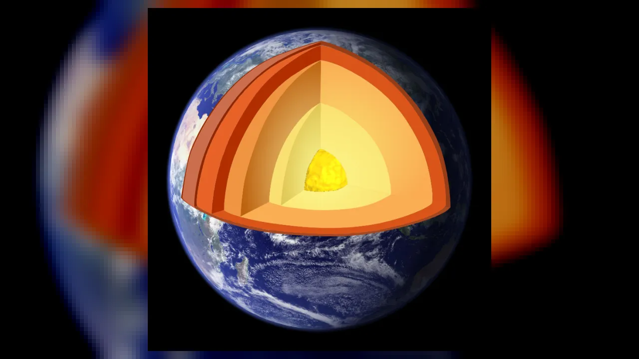
the super-hot metal center of Earth
🪝
How do scientists peek thousands of miles down to Earth's core without ever digging a hole that deep?
1
Ripples Through Solid Rock
Toss a pebble into a quiet pond, and rings of ripples spread outward across the water. When giant slabs of Earth's crust—called tectonic plates—grind past each other along a line, invisible energy ripples race right through solid rock!
2
Solar-Powered Field Stations
Wearing hiking boots and hard hats, earthquake scientists install solar-powered on remote mountaintops, deserts, and even the ocean floor. Each station records the exact split-second underground waves arrive and beams data to lab computers.
3
X-Raying Our Planet
Because earthquake waves speed up, slow down, or bounce when crossing liquid metal and solid rock, scientists use them to map Earth's deep mantle and !
1. How do earthquake waves travel outward when rocks slip along a fault?
2. How have scientists discovered what lies thousands of miles deep inside Earth?
🤯 Mind-Blowing Fact • Grade 3
In 132 CE—nearly two thousand years ago—Chinese inventor Zhang Heng built a bronze dragon jar that dropped a metal ball into a bronze toad's mouth to show which direction a distant earthquake struck!
✨ Word Sparks (Grade 3 Glossary)
Tap 🔊 to hear
epicenter
surface spot directly above an earthquake's start
tectonic plates
giant puzzle slabs forming Earth's outer shell
magnitude
number measuring total energy released by quakes
🪝
Why does every earthquake actually send out a fast 'warning wave' ahead of its strongest shaking?
1
Racing Waves: P-Waves and S-Waves
Picture stretching a metal Slinky across a classroom floor! Push one end straight forward, and a fast compression pulse zips down the coils—just like an earthquake's Primary wave, or P-wave. Shake the Slinky side to side, and a slower, stronger Secondary wave—an S-wave—follows behind.
2
Pinpointing the Epicenter
Because P-waves travel nearly twice as fast as S-waves, the gap in seconds between their arrivals tells a scientist exactly how far away a quake began! Comparing distances from at least three stations lets computers draw overlapping circles on a map to pinpoint the exact .
3
Seconds That Save Lives
Modern early-warning systems like ShakeAlert detect gentle P-waves near a fault and flash electronic warnings at the speed of light—slowing passenger trains, opening firehouse doors, and alerting classrooms seconds before stronger S-waves arrive.
4
Watching Oceans for Tsunamis
When powerful quakes jolt the seafloor, geophysicists team up with ocean warning centers to alert coastal towns long before giant tsunami waves reach shore.
1. How many seismic stations are needed at minimum to pinpoint an earthquake's exact epicenter on a map?
2. Why can early-warning apps alert your phone before strong shaking reaches you?
🤯 Mind-Blowing Fact • Grade 4
Each whole-number step up on the earthquake Moment Magnitude scale—such as moving from magnitude 5.0 to 6.0—releases about thirty-two times more seismic energy!
✨ Word Sparks (Grade 4 Glossary)
Tap 🔊 to hear
seismogram
recorded graph showing ground motion over time
bedrock
solid unbroken rock beneath soil and gravel
mantle
thick hot rock layer beneath Earth's crust
🪝
Why was an earthquake in central Virginia felt by more Americans than almost any quake in history—and how did a Danish woman discover Earth's inner core?
1
Old Cold Rock vs. Young Cracked Crust
Most people link earthquakes with California or Alaska, where Pacific tectonic plates grind actively against North America. Yet on August 23, 2011, a magnitude 5.8 quake centered in Louisa County, Virginia, rattled landmarks from Washington, D.C., all the way to Maine and Georgia! Earthquake scientists explained why: eastern North America's ancient, dense transmits seismic vibrations like a solid bell, whereas western fault zones have warmer, fractured rock that absorbs wave energy much faster.
2
Inge Lehmann and Earth's Hidden Core
Nobody can drill 3,900 miles to Earth's center—the deepest borehole ever drilled reached less than eight miles! Instead, geophysicists read seismic waves. Because side-to-side S-waves cannot travel through liquids, their sudden disappearance on the far side of Earth proved our outer core is molten iron. Then in 1936, pioneering Danish scientist Inge Lehmann studied faint P-wave echoes on paper and discovered a solid metallic inner core spinning right at the planet's heart.
3
From Richter to Moment Magnitude
Modern observatories replace swinging ink pens with electromagnetic broadband sensors and millimeter-precise GPS monuments that track tectonic plates creeping at the speed fingernails grow. Rather than the older Richter scale, scientists calculate the Moment Magnitude scale, which measures fault slip area and rock stiffness—where each whole number jump represents roughly thirty-two times more released energy!
4
Engineering Resilient Cities
Partnering with structural engineers, geophysicists create national hazard maps so hospitals, dams, and bridges rest on flexible shock-absorbing base isolators that sway safely when Earth rumbles.
1. Why did the 2011 Mineral, Virginia earthquake travel much farther than a same-sized California quake?
2. What major discovery did Danish scientist Inge Lehmann make in 1936?
🤯 Mind-Blowing Fact • Grade 5
Using laser light inside ordinary undersea fiber-optic cables, Distributed Acoustic Sensing can turn a single fifty-kilometer glass strand into ten thousand side-by-side earthquake sensors!
✨ Word Sparks (Grade 5 Glossary)
Tap 🔊 to hear
lithosphere
rigid outer shell of crust and upper mantle
tomography
3D imaging built from waves crossing interiors
subduction
one tectonic plate diving beneath another plate
🪝
How do modern geophysicists turn undersea internet cables into million-sensor earthquake arrays—and even catch underground glaciers slipping or nuclear tests firing?
1
Elastic Rebound and Wave Propagation
Deep within Earth's brittle , convection currents in the underlying mantle drive tectonic plates at rates of one to ten centimeters per year. Where rough fault planes lock together by friction, elastic strain accumulates for decades or centuries until rock strength fails—snapping blocks past one another in seconds via elastic rebound. Quantitative geophysicists model the resulting body waves (compressional P-waves traveling up to eight kilometers per second in crust and shear S-waves) alongside slower, higher-amplitude Love and Rayleigh surface waves that cause most structural damage.
2
Seismic Tomography of Planetary Interiors
Much as a medical CT scan reconstructs internal organs from X-ray slices, global seismic synthesizes millions of arrival-time waveforms recorded across the Global Seismographic Network to build three-dimensional velocity models of Earth's interior. Cold, dense subducting ocean slabs speed seismic waves up, whereas buoyant thermal mantle plumes beneath hotspots like Hawaii or Yellowstone slow waves down. Beyond Earth, planetary missions—including Apollo lunar arrays and NASA's InSight lander on Mars—used single-station broadband sensors to measure Martian crustal thickness and core radius.
3
Distributed Acoustic Sensing on Fiber-Optic Cables
One of the most exciting frontiers in twenty-first-century geophysics transforms dark telecommunications fiber-optic cables into ultra-dense earthquake arrays. Firing laser pulses down existing undersea or urban glass fibers—a method called Distributed Acoustic Sensing (DAS)—measures microscopic strain changes every few meters over tens of kilometers, revealing previously unmapped offshore faults without deploying expensive ocean-bottom vessels.
4
Environmental Seismology and Treaty Verification
Modern broadband instruments record far more than tectonic slip. Cryoseismologists listen to Greenland and Antarctic glaciers calving cubic kilometers of ice into polar seas; volcano geophysicists detect rhythmic harmonic tremors as magma ascends dikes; and forensic analysts at international monitoring stations distinguish the sharp, symmetric P-wave pulse of an underground explosion from the shear-rich double-couple signature of a natural fault—enforcing global nuclear test-ban treaties.
5
Probabilistic Hazard Mapping and Early Warning
While exact day-and-hour earthquake prediction remains physically elusive, U.S. Geological Survey teams integrate paleoseismic trenching, Interferometric Synthetic Aperture Radar (InSAR) satellite crustal deformation, and real-time ShakeAlert algorithms to harden lifelines, guide seismic building codes, and protect millions of citizens living near active faults.