💎 EARTH SCIENCE
🪨 Circum-Pacific Tectonic Belt
VA Science SOL 1.6, 2.6, 3.7, 4.4, 4.7, 5.8 (Weather, Rocks, Oceans & Earth Systems)
Ring of Fire
Earth's Giant Horseshoe of Rumbling Volcanoes
Grade 2 • Developing • 102 words
🌍 Earth Science TypePlate Tectonics & Volcanology
🌋 Where It Forms40,000 km Rim Around the Pacific Ocean Basin
💎 Key Properties450+ Active & Dormant Volcanoes, Deep Ocean Trenches
⚡ Planet Earth SparkHosts 75% of Earth's volcanoes and 90% of its earthquakes
🤯 Mind-Blowing Fact • Grade 1
Three out of every four active volcanoes on Planet Earth sit along the Ring of Fire!
✨ Word Sparks (Grade 1 Glossary)
Tap 🔊 to hear
volcano
A mountain opening where hot melted rock escapes.
ocean
A huge body of salty water covering Earth.
lava
Hot melted rock flowing onto Earth's surface.
🪝
Did you know a giant loop of volcanoes hugs the biggest ocean on Earth?
1
A Big Loop Around the Sea
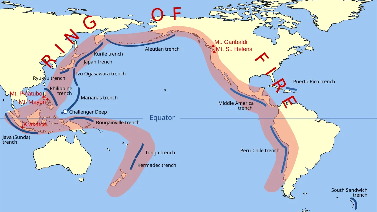
Trace your finger around the edge of the Pacific . You just drew a giant horseshoe! Scientists call this path the Ring of Fire. It is not a real ring of flames.
2
Shaking and Steaming
Instead, hundreds of tall sit along this path. Deep under the ground, big slabs of rock push together. That pushing makes the ground rumble and shake.
3
Islands Born From Lava
Hot melted rock pops up to build new islands. Countries like Japan and Chile sit right on this busy, rumbling loop!
1. What shape does the Ring of Fire actually make on a map?
2. Which huge ocean is surrounded by the Ring of Fire?
🤯 Mind-Blowing Fact • Grade 2
About nine out of every ten earthquakes in the entire world happen somewhere along the Ring of Fire!
✨ Word Sparks (Grade 2 Glossary)
Tap 🔊 to hear
plates
Giant slabs of rock forming Earth's outer shell.
earthquake
Sudden shaking of the ground from moving rock.
geologist
A scientist who studies rocks and Earth's history.
🪝
Why do so many earthquakes and volcanoes happen around the edge of just one ocean?
1
A Horseshoe, Not a Circle
Imagine looking down at the Pacific Ocean from outer space. Around its edges stretches a massive, curving path shaped like a horseshoe. call this path the Ring of Fire, and it reaches nearly 25,000 miles long!
2
Crashing Puzzle Pieces
Earth's outer shell is cracked into giant rocky puzzle pieces called . Along the Pacific rim, these heavy plates bump, scrape, and dive beneath one another. Every jolt sends waves racing through the ground.
3
Hundreds of Volcanoes
Where dive deep underground, rock melts and rises to build steaming volcanoes. More than 450 volcanoes dot coasts from South America and Alaska all the way to Japan and New Zealand.
1. About how long is the curving path of the Ring of Fire?
2. Why does the Ring of Fire have so many earthquakes and volcanoes?
🤯 Mind-Blowing Fact • Grade 3
The Mariana Trench on the western edge of the Ring of Fire plunges nearly 11 kilometers deep—deeper than Mount Everest is tall!
✨ Word Sparks (Grade 3 Glossary)
Tap 🔊 to hear
tectonic plate
A massive moving piece of Earth's rocky crust.
ocean trench
A deep, narrow canyon on the ocean floor.
magma
Super-hot melted rock trapped beneath Earth's surface.
🪝
How can one 25,000-mile belt hold three-quarters of Earth's volcanoes AND its deepest ocean trenches?
1
Tracing the Pacific Rim
Picture a colossal horseshoe curving from New Zealand, up past Indonesia and Japan, across Alaska's Aleutian Islands, and down the western coasts of North and South America. This 40,000-kilometer tectonic belt is famous worldwide as the Ring of Fire.
2
Plate Boundaries in Motion
Earth's crust is divided into slow-moving that drift just a few centimeters each year. Around the Pacific Ocean, dense oceanic plates collide with lighter continental plates and sink into the hot mantle below.
3
Deep Trenches and Volcanic Arcs
Where a sinking plate bends downward, it carves a steep underwater canyon called an , including the record-breaking Mariana Trench. Farther inland, trapped water helps melt rock into , feeding chains of towering volcanoes.
4
Living Prepared on Active Ground
Famous peaks like Mount St. Helens in Washington and Mount Fuji in Japan stand along this zone. Communities here build flexible skyscrapers and use early-warning sensors to stay safe when the ground trembles.
1. Which famous U.S. volcano sits along the Ring of Fire in Washington State?
2. What underwater feature forms right where an oceanic plate bends and sinks downward?
🤯 Mind-Blowing Fact • Grade 4
Paradoxically, cold seawater carried deep underground by sinking ocean plates actually helps hot mantle rock melt faster to fuel Ring of Fire volcanoes!
✨ Word Sparks (Grade 4 Glossary)
Tap 🔊 to hear
subduction
One tectonic plate sinking beneath another rocky plate.
island arc
A curved chain of volcanic islands near trenches.
seismic
Related to vibrations caused by earthquakes underground.
🪝
What invisible conveyor belt beneath the Pacific Ocean powers 450 volcanoes from the Andes to Alaska?
1
A Planet-Scale Tectonic Belt
Sweep your eyes around a physical map of the Pacific basin, and a dramatic pattern jumps out: mountain ranges, , and deep-sea trenches outline the entire ocean like a 40,000-kilometer horseshoe. Known to geologists as the Circum-Pacific Belt—and to everyone else as the Ring of Fire—this active zone contains roughly 75 percent of Earth's volcanoes and produces 90 percent of its earthquakes.
2
Subduction Drives the Action
The secret behind this nonstop activity is plate tectonics, a core concept in Virginia Earth science. Several oceanic plates, including the huge Pacific, Nazca, and Philippine Sea plates, press outward against surrounding continents. Because basaltic oceanic crust is denser than granitic continental crust, the ocean floor plunges beneath the continents at convergent boundaries called zones.
3
Melting Rock With Seawater
As a subducting slab sinks into the mantle, intense heat and pressure squeeze seawater out of its minerals. Surprisingly, adding water lowers the melting temperature of the hot mantle rock above it! Pockets of buoyant magma form and rise through the overriding plate, erupting to build continental mountain chains like the Andes and Cascades, or curved like Japan and the Aleutians.
4
Monitoring a Dynamic Rim
Not every stretch of the Ring of Fire subducts—California's San Andreas Fault is a transform boundary where plates grind sideways. Across the Pacific, scientists track waves, satellite ground tilt, and ocean buoys to protect millions of coastal residents.
1. Why do oceanic plates sink beneath continental plates along most of the Ring of Fire?
2. How does trapped seawater in a sinking plate help create volcanoes?
🤯 Mind-Blowing Fact • Grade 5
Despite sharing a name, tectonic plates along the Ring of Fire move independently—so a volcanic eruption in Japan cannot trigger a chain-reaction earthquake across the ocean in California!
✨ Word Sparks (Grade 5 Glossary)
Tap 🔊 to hear
lithosphere
Earth's rigid outer layer of crust and upper mantle.
flux melting
Rock melting triggered when water enters hot mantle.
geothermal
Natural heat energy coming from inside Planet Earth.
🪝
Why is the Ring of Fire actually a collection of separate tectonic collisions rather than one single connected ring?
1
Anatomy of the Circum-Pacific Belt
From the glaciated cones of Tierra del Fuego at the tip of South America to the steaming craters of Kamchatka and New Zealand's Taupo Volcanic Zone, a 40,000-kilometer arc of geologic intensity frames the Pacific Ocean. Formally named the Circum-Pacific Belt, the Ring of Fire encompasses more than 450 active and dormant volcanoes, generates roughly 90 percent of global seismic energy, and has produced almost every magnitude 9.0+ megathrust earthquake in recorded history.
2
A Mosaic of Interacting Plates
Despite its unified nickname, the Ring of Fire is not driven by a single circular structure. Instead, it marks the shifting margins of multiple independent lithospheric plates—principally the vast Pacific Plate alongside the Juan de Fuca, Cocos, Nazca, Philippine Sea, and Indo-Australian plates. Moving at rates between 2 and 10 centimeters per year, these plates converge with or slide past surrounding plates independently, meaning an eruption in Indonesia does not trigger an earthquake in Chile.
3
Trenches, Flux Melting, and Volcanic Arcs
Most of the belt consists of convergent subduction zones. Where cold, dense oceanic bends into the asthenosphere, it sculpts abyssal trenches such as the Peru-Chile, Kuril, Tonga, and Mariana trenches. Roughly 100 kilometers down, hydrous minerals inside the descending slab dehydrate, releasing superheated volatiles into the overlying mantle wedge. This process——generates silica-rich, gas-charged magmas that construct steep stratovolcanoes parallel to each trench.
4
Transform Segments and Geothermal Wealth
Two notable segments break the subduction pattern: along California's San Andreas system and New Zealand's Alpine Fault, plates shear horizontally along transform boundaries, sparking shallow earthquakes without building volcanic cones. Meanwhile, the same magmatic heat that poses hazards also enriches the Pacific Rim with copper-gold porphyry deposits, fertile volcanic soils, and clean electricity.
5
Global Science and Hazard Resilience
Today, international networks of broadband seismometers, GPS stations, InSAR satellites, and DART deep-ocean tsunami buoys monitor every tremor along the belt, turning plate-tectonic science into lifesaving minutes of warning.