1. Where do ocean clouds drop most of their rain and snow?
2. Why is the land behind the mountain called a 'rain shadow'?
🤯 Mind-Blowing Fact • Grade 2
Parts of Chile's Atacama Desert—trapped in a double rain shadow between two mountain ranges—went decades without a single measurable raindrop!
✨ Word Sparks (Grade 2 Glossary)
Tap 🔊 to hear
windward
Mountain side facing into oncoming wind
leeward
Sheltered side downwind behind a mountain
sagebrush
Tough silvery shrub of dry lands
🪝
What happens to a wet sponge when you squeeze it—and how does a mountain do that to clouds?
1
Two Worlds on One Mountain
Drive east across Washington State or Oregon, and the scenery changes like magic! Giant mossy fir trees drip with rain on the western slopes of the Cascade Mountains, yet golden desert stretches out just fifty miles east.
2
Squeezing the Cloud Sponge
Moist breezes blow inland from the Pacific Ocean and climb the steep side of the mountains. High up where the air is chilly, water vapor turns into heavy rain and deep winter snow, wringing the clouds dry like a sponge.
3
Warm Sinking Air
Now empty of moisture, the air rolls down the sheltered side and warms up as it sinks. Warm, thirsty air evaporates puddles and creates a sunny rain shadow desert!
1. What do scientists call the wet mountain slope that faces directly into ocean winds?
2. What happens to air temperature as dry air sinks down the back side of a mountain?
🤯 Mind-Blowing Fact • Grade 3
Sequim, Washington, sits in such a sharp Olympic Mountain rain shadow that locals call it 'Sunny Sequim'—getting just sixteen inches of rain while nearby rainforests get twelve feet!
✨ Word Sparks (Grade 3 Glossary)
Tap 🔊 to hear
orographic
Weather shaped by tall mountain terrain
summit
Highest point at a mountain's top
humidity
Amount of water vapor in air
🪝
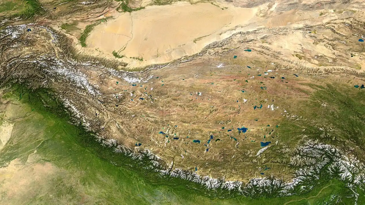
How did the Himalaya Mountains build the high, cold Gobi and Taklamakan Deserts?
1
Orographic Lift in Action
Whenever moving air meets a mountain barrier, it cannot tunnel through solid rock—it must climb over the top! Weather scientists call this forced climb lift. As moist ocean air rises higher, lower air pressure lets it expand and cool until invisible water vapor condenses into thick clouds, drenching the windward slopes.
2
Descending Into the Shadow
After cresting the ridge, the wrung-out air plunges down the leeward slope. Higher air pressure near the valley floor squeezes the sinking air molecules closer together, warming the wind rapidly and shrinking relative so clouds vanish.
3
Famous American Rain Shadows
North America showcases spectacular rain shadows! California's Sierra Nevada blocks Pacific storms to create the Great Basin across Nevada and scorching Death Valley. Farther east, even Virginia's Shenandoah Valley gets noticeably less rain than the high Blue Ridge peaks flanking it.
4
Cold Rain Shadows in Asia
Not all rain shadow deserts are hot: behind the towering Himalayas lie the cold, windswept Tibetan Plateau and Gobi Desert!
1. Why does moist air cool down as it climbs up the windward side of a mountain?
2. Can a rain shadow desert be cold in winter instead of hot all year?
🤯 Mind-Blowing Fact • Grade 4
Warm downslope 'Chinook' winds roaring down the eastern Rockies can raise winter temperatures by forty degrees Fahrenheit in less than an hour!
✨ Word Sparks (Grade 4 Glossary)
Tap 🔊 to hear
parcel
Imaginary pocket of air tracked together
latent
Hidden heat released when vapor condenses
Chinook
Warm dry wind blowing down mountains
🪝
Why does air come down the leeward side of a mountain even warmer than when it started at the beach?
1
A Surprising Temperature Trick
Follow a of mild 60 °F air blowing off the Pacific Ocean toward the 10,000-foot Cascade Range. At first, dry rising air cools rapidly—about 5.5 °F for every thousand feet of climb. Once clouds form, however, condensing water vapor releases stored heat into the air, slowing the cooling rate to roughly 3 °F per thousand feet while snow piles onto the peaks.
2
Chinook and Foehn Winds
Here comes the surprise! Having lost its cloud droplets on the windward slope, the air descends the leeward side completely cloud-free, warming at the faster dry rate of 5.5 °F every thousand feet all the way down. By the time it reaches the eastern basin, the wind is not only bone-dry—it can be fifteen to twenty degrees warmer than when it left the ocean! Westerners call these warm, snow-eating downslope gusts winds.
3
Rain Shadows Across Continents
This thermodynamic engine sculpts iconic landscapes worldwide: Argentina's windswept Patagonian Steppe east of the Andes, Hawaii's sunny Kona and Kohala coasts, and Nevada's arid Great Basin behind the Sierra Nevada.
4
Appalachian Echoes in Virginia
Even older, gentler ranges cast modest rain shadows: West Virginia's Allegheny Highlands wring heavy snow from winter westerlies, leaving parts of Virginia's Shenandoah and South Branch valleys noticeably drier!
1. Why does air often arrive warmer at the leeward desert base than when it started on the ocean side?
2. Which mountain range creates a modest rain shadow over parts of Virginia's Shenandoah Valley?
🤯 Mind-Blowing Fact • Grade 5
Geologists can tell how tall ancient mountains stood millions of years ago by measuring oxygen isotopes left behind by rain shadows in fossilized valley soils!
✨ Word Sparks (Grade 5 Glossary)
Tap 🔊 to hear
adiabatic
Temperature change from air expanding or compressing
tectonic
Driven by Earth's moving crustal plates
isotope
Atom variety with slightly different weight
🪝
How did tectonic uplift of mountain ranges millions of years ago trigger new deserts and reshape evolution?
1
Moist vs. Dry Adiabatic Lapse Rates
Quantitative meteorology explains rain shadows by comparing two fundamental cooling and warming rates. Unsaturated air ascending a mountain slope expands against lower ambient pressure and cools at the dry lapse rate (DALR) of $9.8\,^{\circ}\text{C}$ per kilometer. Once the parcel cools to its lifting condensation level (LCL), saturated cloud air ascends at the much gentler moist adiabatic lapse rate (MALR), averaging $5\text{ to }6\,^{\circ}\text{C}$ per kilometer because condensing droplets release $2.5 \times 10^{6}$ joules of latent heat per kilogram of water. After precipitation strips moisture over the crest, unsaturated air plunges down the leeward slope warming at the full $9.8\,^{\circ}\text{C}/\text{km}$ DALR—plunging relative humidity below twenty percent.
2
Double Rain Shadows: Atacama and Death Valley
Earth's driest non-polar deserts sit inside compound rain shadows. California's Death Valley (averaging ~50 mm of annual rain) lies downwind of four successive ridges—the Coast Ranges, Sierra Nevada, Panamint Range, and Argus Range—each stripping remaining Pacific moisture. Similarly, Chile's Atacama Desert is blocked on the east by the 6,000-meter Andes from Amazonian moisture and capped on the west by coastal mountains plus cold Humboldt Current inversions.
3
Plate Tectonics as a Climate Sculptor
Fossil pollen and ancient lakebed sediments prove that Nevada and Patagonia once hosted lush woodlands! Only when Cenozoic plate collisions uplifted the Sierra Nevada, Cascades, Andes, and Himalayas did orographic barriers starve inland basins of rain, driving drought-adapted plants like cacti and steppe grasses to evolve.
4
Snowpack Lifelines Into Dry Valleys
Ironically, the same windward peaks that starve leeward basins also save them: melting high-country snowpacks feed rivers like the Yakima, Truckee, and Owens into rain-shadow farms and cities.
5
Isotope Fingerprints in Rocks
Geochemists even reconstruct ancient mountain heights by measuring heavy oxygen-18 vs. light oxygen-16 trapped in fossil rain-shadow soil minerals!