💎 EARTH SCIENCE
🪨 El Niño–Southern Oscillation (ENSO) Coupled Ocean-Atmosphere Cycle
VA Science SOL 1.6, 2.6, 3.7, 4.4, 4.7, 5.8 (Weather, Rocks, Oceans & Earth Systems)
El Nino & La Nina
Pacific Ocean Swings Reshaping Global Weather
Grade 2 • Developing • 107 words
🌍 Earth Science TypeOceanography & Global Climatology
🌋 Where It FormsEquatorial Tropical Pacific Ocean & Global Troposphere
💎 Key Properties2-to-7-Year See-Saw • Warm Phase (El Niño) vs. Cool Phase (La Niña)
⚡ Planet Earth SparkShifts a continent-sized pool of warm Pacific water to rearrange rain, snow, and storms worldwide
🤯 Mind-Blowing Fact • Grade 1
Peruvian fishermen named El Niño hundreds of years ago after noticing warm ocean currents arriving right around December!
✨ Word Sparks (Grade 1 Glossary)
Tap 🔊 to hear
Pacific
Earth's largest and deepest ocean basin
current
A steady stream of moving ocean water
twin
One of two closely linked partners
🪝
Can warm water in one giant ocean change the weather all around the world?
1
A Giant Ocean See-Saw
Splash! The Ocean is the biggest sea on Earth. Every few years, its middle waters turn extra warm or extra cool. Scientists call these two El Niño and La Niña!
2
Warm Brother, Cool Sister
During El Niño, warm ocean water slides east toward South America. During La Niña, strong winds push cool ocean water up to the top.
3
Moving Rain Clouds
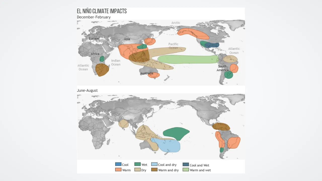
Storm clouds follow the warm ocean water wherever it goes. That changes where rain and winter snow fall across America!
Ocean buoys anchored right along the Pacific equator beam water temperatures up to weather satellites every single day!
✨ Word Sparks (Grade 2 Glossary)
Tap 🔊 to hear
equator
Imaginary line circling Earth's warm middle
buoy
Floating ocean sensor anchored to measure weather
slosh
Splash back and forth inside a basin
🪝
How did fishermen off the coast of Peru discover a global climate pattern?
1
Clues in Fishing Nets
Long ago, fishermen sailing off Peru loved the cold ocean water near their coast because anchovy fish thrived there. Every few Decembers, though, the sea turned surprisingly warm and fish swam away, so sailors named the warm current El Niño.
2
Pushing Warm Water Back and Forth
Normally, steady trade winds blow west across the tropical Pacific, piling warm sun-heated water near Australia and Indonesia. During El Niño, those winds weaken and warm water back east toward the Americas.
3
Enter Cool La Niña
In other years, the trade winds blow even harder than usual! Extra-strong winds push warm water far west and pull chilly deep water upward, starting the opposite phase called La Niña.
1. What happens to Pacific trade winds when an El Niño event begins?
2. Why did Peruvian fishermen notice El Niño right away?
🤯 Mind-Blowing Fact • Grade 3
The pool of warm Pacific water that shifts during a strong El Niño holds more heat energy than all the electricity humans generate on Earth in an entire year!
✨ Word Sparks (Grade 3 Glossary)
Tap 🔊 to hear
upwelling
Cold, nutrient-rich deep water rising upward
nutrient
Natural substance living things need to grow
neutral
Balanced in the middle, neither extreme
🪝
How does chilly deep water feed ocean life—and why do U.S. winters change when Pacific winds shift?
1
Upwelling: Nature's Ocean Elevator
Under normal conditions, east-to-west trade winds push warm surface water away from South America toward Indonesia. To replace that moving water, icy-cold water rises from the dark ocean depths off Peru and Ecuador. Scientists call this rising current , and it carries rich that feed plankton, fish, seabirds, and sea lions.
2
El Niño Rearranges the Jet Stream
Every two to seven years, trade winds relax and El Niño arrives. Warm water spreads across the central and eastern Pacific, heating the air above it to build giant thunderstorms. Those towering storms nudge the winter jet stream southward, often bringing wetter winters from California to the Gulf Coast and milder winters across the northern United States.
3
La Niña Flips the Map
During La Niña, supercharged trade winds strengthen cold in the eastern Pacific. In North America, La Niña winters frequently bring drier skies to the Southwest, colder snowier weather to the Northwest, and fewer wind obstacles for Atlantic hurricanes.
4
Neutral Years Between
When Pacific temperatures stay near average, scientists call it ENSO- until the ocean-atmosphere see-saw tips again!
1. Why is cold ocean upwelling off South America so important for sea animals?
2. How often does an El Niño event typically develop in the Pacific Ocean?
🤯 Mind-Blowing Fact • Grade 4
Even though El Niño happens in the Pacific Ocean, its upper-level winds cross Central America and actually slice apart developing hurricanes in the Atlantic Ocean!
✨ Word Sparks (Grade 4 Glossary)
Tap 🔊 to hear
oscillation
Repeated swing back and forth over time
teleconnection
Weather link between faraway regions on Earth
suppress
Hold back or reduce in strength
🪝
Why do Atlantic hurricane forecasters in Virginia and Florida watch Pacific Ocean temperatures thousands of miles away?
1
Connecting Two Halves of ENSO
For decades, sailors knew about Peru's warm El Niño ocean currents, while British mathematician Sir Gilbert Walker independently discovered a giant atmospheric pressure see-saw between Darwin, Australia, and Tahiti, which he named the Southern . In the late 1960s, meteorologist Jacob Bjerknes realized both puzzles were halves of one coupled ocean-atmosphere machine: the El Niño–Southern Oscillation, or ENSO!
2
Walker Circulation and Teleconnections
Normally, rising moist air over warm Indonesian seas and sinking air over cool eastern Pacific waters form a giant east-west loop called the Walker Circulation. When El Niño warms the central and eastern Pacific by at least 0.5 degrees Celsius for several months, that loop shifts or reverses: Indonesia and Australia risk drought, while Peru faces flooding rains. Long-distance weather links—called —ripple outward across continents.
3
Surprise Link to Atlantic Hurricanes
Remarkably, Pacific El Niño summers usually Atlantic hurricanes! Warmer eastern Pacific waters strengthen high-altitude westerly winds blowing across the Caribbean Sea, creating vertical wind shear that slices the tops off developing Atlantic tropical storms. Conversely, cool La Niña summers reduce Atlantic wind shear, often allowing busier hurricane seasons along the East and Gulf Coasts.
4
Helping Farmers and Cities Plan Months Ahead
Because vast ocean water holds heat for months, NOAA's TAO buoy array lets climatologists issue seasonal outlooks half a year early so farmers, water managers, and utility crews can prepare wisely.
1. Why does an El Niño in the Pacific usually lead to FEWER hurricanes in the Atlantic Ocean?
2. Who proved in the 1960s that ocean warming (El Niño) and air pressure swings (Southern Oscillation) are one connected system?
🤯 Mind-Blowing Fact • Grade 5
Steady Pacific trade winds normally pile so much water westward that the ocean surface near Indonesia actually stands about half a meter (nearly twenty inches) higher than the ocean off Ecuador!
How does tilting an invisible underwater boundary called the thermocline alter planetary temperatures across the entire globe?
1
Thermocline Slope and Bjerknes Feedback
Beneath the sunlit mixed layer of the tropical Pacific lies the —a sharp transition zone separating warm surface water from frigid abyssal water near 4 degrees Celsius. During ENSO-neutral and La Niña conditions, easterly trade winds pile warm water into the Western Pacific Warm Pool, raising sea level near Indonesia roughly 50 centimeters higher than off Ecuador and depressing the western thermocline to 150–200 meters depth while lifting it within 30 meters of the surface off Peru. Jacob Bjerknes demonstrated a self-reinforcing loop: if trade winds falter, subsurface Kelvin waves flatten the thermocline eastward, warming eastern waters, weakening the east-west sea-level pressure gradient, and relaxing trade winds even further.
2
Defining the Oceanic Niño Index (ONI)
Operational climatologists monitor sea-surface temperature anomalies inside the central-eastern equatorial 'Niño 3.4' box (5°N–5°S, 120°W–170°W). NOAA declares El Niño when the three-month running mean exceeds +0.5 °C above the thirty-year baseline for five consecutive overlapping periods, and La Niña when anomalies dip to −0.5 °C or colder; 'super El Niños' like 1982–83, 1997–98, and 2015–16 surpassed +2.0 °C.
3
Planetary Heat Release and Coral Bleaching
Because cold upwelling normally buries solar heat in the Pacific, La Niña years temporarily cool global average surface air temperatures slightly. Conversely, strong El Niño events spread warm water across millions of square kilometers, venting vast ocean heat into the atmosphere, spiking global annual temperature records, and stressing tropical coral reefs.
4
Rossby Wave Trains and Jet Stream Shifts
Deep tropical convection acts like a boulder dropped in an atmospheric river, launching planetary Rossby waves poleward that split and amplify the Pacific-North American jet stream.
5
Observing ENSO From Depth to Orbit
Today, nearly seventy moored TAO/TRITON buoys, thousands of autonomous diving Argo floats, and radar satellites measure subsurface heat content months before surface anomalies peak, giving humanity unprecedented climate foresight.