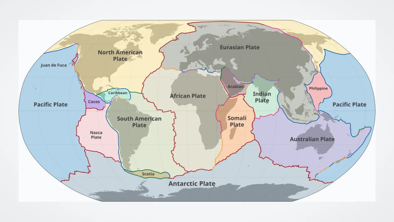
1. Why do the coastlines of South America and Africa match up like puzzle pieces?
2. What happens along the edges where giant tectonic plates bump and rub together?
🤯 Mind-Blowing Fact • Grade 2
In Iceland, the North American and Eurasian tectonic plates pull apart right across dry land—so visitors can stand with one foot on each plate!
✨ Word Sparks (Grade 2 Glossary)
Tap 🔊 to hear
Pangaea
Ancient supercontinent uniting all Earth's landmasses
Boundary
Border line where two tectonic plates meet
Mid-Ocean Ridge
Underwater mountain chain where plates pull apart
🪝
What was Earth like when every single continent was joined into one giant supercontinent?
1
Pangaea: One Giant Land
Travel back 250 million years, and you could have walked from Virginia to Africa without ever getting your shoes wet! Back then, Earth's moving tectonic plates had brought all major landmasses together into a supercontinent called .
2
Three Ways Plates Meet
About fifteen big and medium tectonic plates cover our globe, carrying both dry land and ocean floors. Plates can pull apart to make new seafloor, crash together to push up mountains and volcanoes, or scrape sideways past each other!
3
Matching Fossil Clues
Scientists proved continents moved by finding identical fern fossils and ancient reptile bones on shores now separated by wide oceans!
1. What did scientists name the giant supercontinent that connected almost all land 250 million years ago?
2. How did fossils of land plants and freshwater reptiles help prove continents drifted apart?
🤯 Mind-Blowing Fact • Grade 3
GPS satellites in space are so accurate today that scientists can watch tectonic plates creep millimeter by millimeter in real time on computer screens!
✨ Word Sparks (Grade 3 Glossary)
Tap 🔊 to hear
Divergent
Plate boundary where two slabs pull apart
Convergent
Plate boundary where two slabs collide together
Transform
Plate boundary where slabs slide sideways past
🪝
What is the difference between a divergent, convergent, and transform plate boundary?
1
Divergent: Pulling Apart
Where two tectonic plates move away from each other—a boundary—hot magma rises to fill the gap! Underwater, divergent plates build the 40,000-mile Mid-Ocean Ridge system; on land, they split open deep valleys like Africa's East African Rift.
2
Convergent: Crashing Together
At a boundary, two plates collide head-on! When dense oceanic crust meets lighter continental crust, the ocean plate dives downward (subduction), forming deep ocean trenches and volcanic mountain arcs like the Andes and Cascades. When two buoyant continents collide—like India and Eurasia—neither sinks, crumpling rock upward into the towering Himalayas!
3
Transform: Sliding Sideways
At a boundary, two plates grind past each other horizontally without making or destroying crust. California's famous San Andreas Fault is a transform boundary where stuck plates occasionally snap forward in earthquakes.
4
The Pacific Ring of Fire
Trace the outer rim of the giant Pacific Plate on a globe, and trenches circle it with 75 percent of Earth's active volcanoes—nicknamed the Ring of Fire!
1. Which type of plate boundary built the towering Himalaya Mountains—and keeps pushing Mount Everest slightly higher?
2. What happens along California's San Andreas Fault, a classic transform boundary?
🤯 Mind-Blowing Fact • Grade 4
Oceanographic cartographer Marie Tharp hand-drew the first detailed maps of the Atlantic Ocean floor in the 1950s—discovering the giant Mid-Atlantic Rift Valley that convinced doubting geologists continental drift was real!
✨ Word Sparks (Grade 4 Glossary)
Tap 🔊 to hear
Seafloor Spreading
New ocean crust forming at mid-ocean ridges
Slab Pull
Heavy sinking ocean plate dragging plate behind
Orogeny
Mountain-building event caused by colliding tectonic plates
🪝
How did Virginia's Appalachian Mountains once stand as tall as the Himalayas—right in the middle of Pangaea?
1
From Wegener's Puzzle to Seafloor Spreading
When meteorologist Alfred Wegener proposed 'continental drift' in 1912 using matching coastlines, Glossopteris fern fossils, and glacial scratches, skeptics asked ONE tough question: 'How could solid continents plow through solid ocean rock?' During the 1950s and 1960s, oceanographers Marie Tharp, Bruce Heezen, and Harry Hess solved the riddle! Sonar maps revealed a global mid-ocean rift valley, and magnetometer ships discovered symmetrical zebra stripes of normal and reversed magnetism frozen in seafloor basalt—proving whole lithospheric plates (~100 km thick, combining crust AND rigid top mantle) move together atop the soft asthenosphere!
2
How Plates Built Virginia's Mountains and Coast
Virginia's landscape is a museum of plate tectonics! Around 300 million years ago during the Alleghanian , ancient Africa (Gondwana) collided head-on with ancestral North America to assemble Pangaea—folding Valley and Ridge limestones like a rug and thrusting Blue Ridge rocks skyward into a mountain range rivaling the modern Himalayas! Later, around 200 million years ago, Pangaea rifted apart along divergent valleys (leaving red Triassic rift basins like Culpeper!), opening the modern Atlantic Ocean.
3
Slab Pull and Ridge Push
Modern geophysicists discovered that plates are not just passive rafts riding mantle currents! Cold, dense oceanic crust sinking into subduction trenches acts like a heavy anchor dragging the rest of the plate behind it (''), assisted by elevated mid-ocean ridges sliding downhill ('ridge push').
4
Speed Champions of the Globe
Plates with big subduction trenches race fastest: the Nazca and Pacific plates zip along at 10 to 15 centimeters per year, while the Atlantic-bordered Eurasian and North American plates stroll at ~2.5 centimeters per year.
1. How did ancient plate tectonics create Virginia's Blue Ridge and Valley and Ridge mountains?
2. What seafloor discovery in the 1950s and 1960s proved Harry Hess's seafloor spreading and plate tectonics?
🤯 Mind-Blowing Fact • Grade 5
Deep inside subduction zones, high pressure squeezes ordinary dark seafloor basalt into a dazzling red-and-green gemstone rock called 'eclogite' (made of ruby-red garnet and emerald-green omphacite) so heavy that it pulls tectonic plates down into the mantle like an anchor!
✨ Word Sparks (Grade 5 Glossary)
Tap 🔊 to hear
Wilson Cycle
Repeating cycle of supercontinents assembling and rifting
Eclogite
Ultra-dense red-and-green rock pulling subducting slabs
Wadati-Benioff Zone
Slanted earthquake zone tracing a sinking slab
🪝
What is the 'Wilson Cycle'—and what will Earth's map look like 250 million years in the future as tectonic plates assemble the next supercontinent?
1
Kinematic Geometry on a Sphere: Euler Poles
Unifying seismology, paleomagnetism, stratigraphy, and geodynamics in the late 1960s, plate tectonics did for Earth sciences what evolution did for biology and atomic theory did for chemistry! Earth's rigid outer lithosphere (50 to 200 km thick) comprises seven major plates—Pacific, North American, Eurasian, African, Antarctic, Indo-Australian, and South American—plus dozens of minor plates like Nazca, Juan de Fuca, Philippine Sea, and Arabian. Because plates glide across a spherical planet rather than a flat tabletop, every plate's motion follows Euler's rotation theorem around a geometric pivot axis ('pole of rotation'), meaning spreading rates along a single mid-ocean ridge increase systematically toward its tectonic equator while fracture zones trace exact small circles!
2
Force Balance: Why Slab Pull Dominates
In 1975, geophysicists Donald Forsyth and Seiya Uyeda analyzed global plate velocities and solved a major dynamic question: plates attached to long subducting slabs (such as Pacific, Nazca, and Cocos) travel 3 to 5 times faster than plates lacking major trenches (North American, African, Antarctic)! Negative buoyancy of cold, dense oceanic lithosphere—amplified past 50 km depth as mafic basalt transforms into ultra-dense garnet-pyroxene '' (~3.5 g/cm³)—makes gravitational 'slab pull' roughly 70 to 80 percent of the total driving force of plate tectonics, complemented by elevated gravitational 'ridge push' and basal mantle drag.
3
The Wilson Cycle of Supercontinents
Named after Canadian geophysicist J. Tuzo Wilson, the describes the 300-to-500-million-year rhythm in which supercontinents assemble, trap mantle heat beneath thick continental insulation, rift apart to birth young oceans (like today's Red Sea and Atlantic), mature, and eventually close again via subduction! Before Pangaea (~335–175 Ma), Earth hosted Rodinia (~1.1 billion years ago) and Columbia/Nuna (~1.8 billion years ago). Looking ~250 million years ahead, geodynamicists project 'Pangaea Ultima' or 'Amasia' as the Americas, Africa, Eurasia, and Australia converge once again.
4
Wadati-Benioff Zones and Megathrust Seismology
Along convergent margins like Cascadia, Japan, and Chile, inclined planes of earthquake foci——trace brittle subducting slabs down to 670 kilometers! Shallow locked megathrust interfaces accumulate elastic strain over centuries before rupturing in M8–M9 earthquakes and displacing ocean columns as transoceanic tsunamis.
5
Plate Tectonics and Planetary Habitability
Why hasn't Earth suffered Venus's runaway greenhouse or Mars's deep freeze? Plate tectonics powers the long-term geological carbon thermostat—subducting seafloor carbonate rocks and outgassing balanced volcanic CO2 while uplifting fresh silicate mountains whose weathering draws excess greenhouse gas back into the oceans, sustaining liquid oceans for over four billion years!
1. Why do tectonic plates attached to big subduction trenches (like the Pacific and Nazca plates) move several times faster than plates without major trenches?
2. How does plate tectonics help keep Earth's climate habitable over hundreds of millions of years?