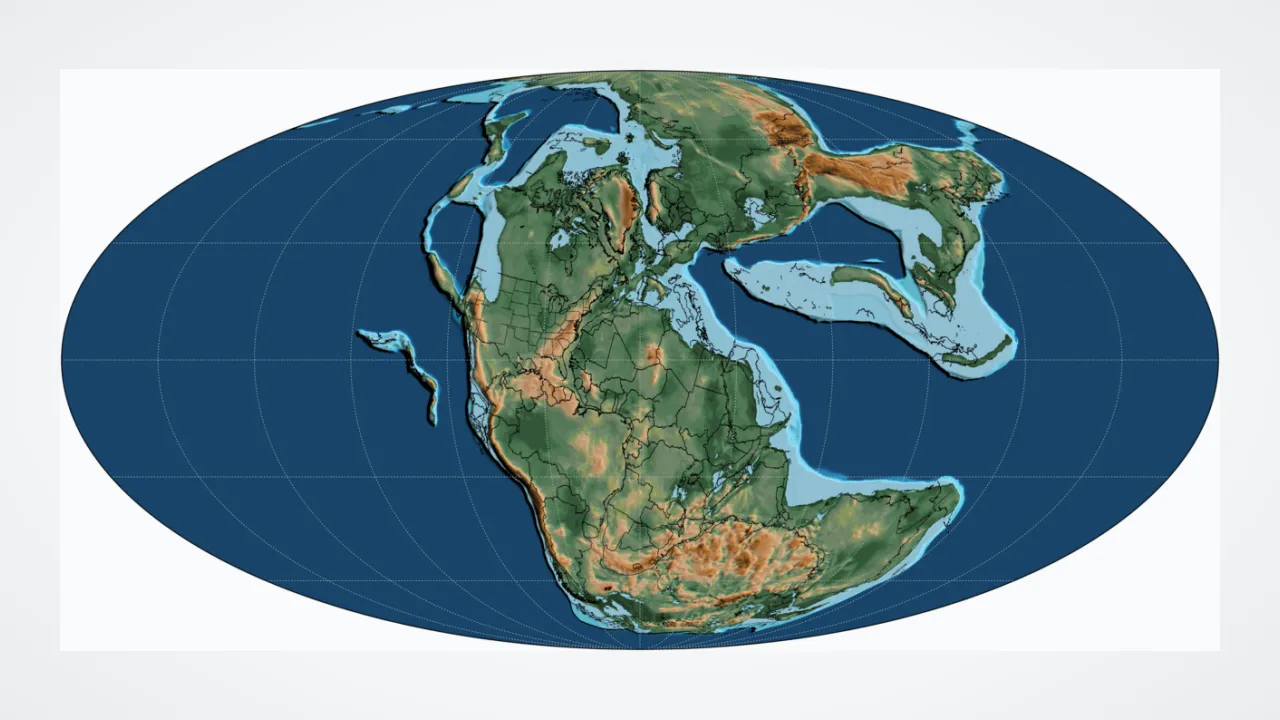
1. What does the ancient Greek name 'Pangaea' mean?
2. Which two continents on a map today look easiest to snap back together like puzzle pieces?
🤯 Mind-Blowing Fact • Grade 2
Virginia's Blue Ridge and Appalachian Mountains actually rose up when ancient continents crashed together to build Pangaea!
✨ Word Sparks (Grade 2 Glossary)
Tap 🔊 to hear
fossil
Preserved remains or traces of ancient living things.
Panthalassa
The single giant ocean that surrounded Pangaea.
ancient
Belonging to a time very, very long ago.
🪝
Why did scientists find fossils of the exact same land reptiles on opposite sides of the Atlantic Ocean?
1
Clues Across the Sea
Imagine digging up of a stubby-legged land reptile in Brazil—and then finding the exact same reptile fossils across the ocean in South Africa! That little creature could never swim across 3,000 miles of salty ocean water.
2
Meet Giant Pangaea
About 300 million years ago, it did not have to swim at all! Every continent was squished together into one C-shaped supercontinent called Pangaea, surrounded by one mega-ocean named .
3
The Great Breakup
Around 200 million years ago, hot magma began cracking Pangaea apart. As new ocean floor spread between the pieces, the continents slowly drifted to where they sit today.
1. How did fossils of the same land animals end up in both South America and Africa?
2. What was the name of the single giant ocean surrounding Pangaea?
🤯 Mind-Blowing Fact • Grade 3
Fossils of the leafy fern Glossopteris have been found beneath the snow in Antarctica, proving that frozen continent once shared warmer land inside Pangaea!
How did matching fossils, coal beds, and mountain chains convince Alfred Wegener that continents move?
1
Four Kinds of Evidence
In 1912, German meteorologist Alfred Wegener pieced together a bold detective story. Not only did coastlines across the Atlantic match up, so did ancient rock layers! Mountain belts in North America lined up seamlessly with mountains in Scotland and Norway.
2
Ferns, Reptiles, and Glaciers
Wegener also mapped fossils of the seed fern and freshwater reptile Mesosaurus across South America, Africa, India, Antarctica, and Australia. Even stranger, glacial ice scratches showed southern lands once huddled together near the icy South Pole!
3
Life Inside a Mega-Continent
Because Pangaea's center sat thousands of kilometers from moist ocean breezes, its vast interior baked into scorching red deserts while lush coal swamps fringed earlier tropical coasts.
4
Splitting Into Laurasia and Gondwana
Roughly 200 million years ago during the Triassic and early Mesozoic eras, Pangaea rifted first into two big pieces—northern Laurasia and southern —before opening today's Atlantic Ocean.
1. Which scientist gathered coastline, rock, glacier, and fossil clues in 1912 to propose Pangaea?
2. Why was the deep interior of Pangaea mostly dry desert?
🤯 Mind-Blowing Fact • Grade 4
Parts of the Scottish Highlands, Morocco's Atlas Mountains, and Virginia's Appalachians were all born as one single mountain range at the heart of Pangaea!
✨ Word Sparks (Grade 4 Glossary)
Tap 🔊 to hear
Laurasia
Northern supercontinent holding North America and Eurasia.
Tethys Sea
Warm tropical sea tucked inside C-shaped Pangaea.
striations
Grooves scratched into bedrock by moving glaciers.
🪝
Did you know the rocks beneath Virginia once collided head-on with northwestern Africa to weld Pangaea together?
1
Building the Central Pangaean Mountains
Hike along Virginia's Shenandoah Valley or Blue Ridge Parkway today, and you are walking across the eroded roots of a prehistoric super-collision! Roughly 335 million years ago during the Carboniferous and Permian periods, ancestral North America (Laurentia) and northwestern Africa (part of Gondwana) slammed together. That slow-motion crash welded Earth's landmasses into Pangaea and thrust the Central Pangaean Mountains as high as today's Himalayas.
2
Panthalassa, the Tethys Sea, and Mega-Monsoons
Shaped like a giant letter C straddling the equator from pole to pole, Pangaea cradled a warm triangular tropical bay on its eastern side called the , while the global Panthalassa Ocean wrapped around the rest of the planet. Extreme temperature swings between summer and winter drove fierce seasonal 'mega-monsoons' along the coasts while leaving the landlocked interior bone-dry.
3
Wegener's Evidence Meets Plate Tectonics
When Alfred Wegener presented matching continental shelves, Mesosaurus and Lystrosaurus fossils, Glossopteris flora, and Permian glacial , critics asked how continents could move. Decades later, seafloor spreading provided the missing engine, uniting Wegener's vision with Virginia SOL plate tectonics!
4
Rifting Apart—and Virginia's Triassic Basins
Around 200 million years ago, upwelling mantle heat stretched Pangaea apart into northern and southern Gondwana. Right across central Virginia—near Culpeper and Richmond—sinking rift valleys filled with dinosaur footprints and volcanic basalt before the main break opened the Atlantic Ocean farther east!
1. How did Virginia's Appalachian Mountains originally form?
2. Why are three-toed dinosaur footprints and ancient rift basins preserved in central Virginia today?
🤯 Mind-Blowing Fact • Grade 5
When scientist Edward Bullard used a computer in 1965 to match continents along their underwater continental shelves instead of beaches, South America and Africa fit together within less than one degree of error!
✨ Word Sparks (Grade 5 Glossary)
Tap 🔊 to hear
Wilson Cycle
Repeating geologic cycle of oceans opening and closing.
orogeny
Mountain-building event caused by colliding tectonic plates.
Rodinia
Ancient supercontinent that existed long before Pangaea.
🪝
Was Pangaea the first supercontinent on Earth—or just the most recent chapter in a 500-million-year planetary cycle?
1
The Supercontinent Cycle and Wilson Cycles
Although Pangaea is the most famous supercontinent, Earth has assembled and shattered giant landmasses repeatedly over billions of years—including earlier supercontinents named Columbia (Nuna) around 1.8 billion years ago and around 1 billion years ago. Canadian geophysicist J. Tuzo Wilson recognized that ocean basins open by rifting and close by subduction in roughly 300-to-500-million-year loops now called . Pangaea represents the most recent complete assembly!
2
Alleghanian Orogeny and Suture Zones
Pangaea finished assembling around 335 million years ago when Gondwana collided with Laurussia during the Alleghanian-Variscan . That collision squeezed shut an ancient ocean, folding sedimentary strata dozens of kilometers thick to raise the Central Pangaean Mountains. Today, the split fragments of that single range survive as North America's Appalachians, Morocco's Anti-Atlas, Ireland and Scotland's Caledonides, and western Europe's Variscan belt.
3
Continental Fit at the 1,000-Meter Bathymetric Contour
In 1965, geophysicist Edward Bullard used early computers to test Alfred Wegener's coastline puzzle mathematically. Rather than matching shifting sandy beaches, Bullard aligned the true edges of continental crust along the 1,000-meter underwater continental slope—achieving an astonishing near-zero-gap fit around the Atlantic!
4
CAMP Volcanism and the Birth of the Atlantic
Because thick continental crust acts like a thermal blanket trapping mantle heat underneath, upwelling plumes eventually domed and fractured Pangaea ~201 million years ago. Flood basalts of the Central Atlantic Magmatic Province (CAMP) erupted across four continents—leaving diabase sills across northern Virginia—as Laurasia separated from Gondwana and seafloor spreading birthed the North Atlantic.
5
Evolutionary Divergence and the Next Supercontinent
Splitting Pangaea isolated terrestrial ecosystems on separate continental 'arks,' driving an explosion of mammal, bird, and flowering-plant diversity—while ongoing plate motions suggest another supercontinent will assemble 250 million years from now!