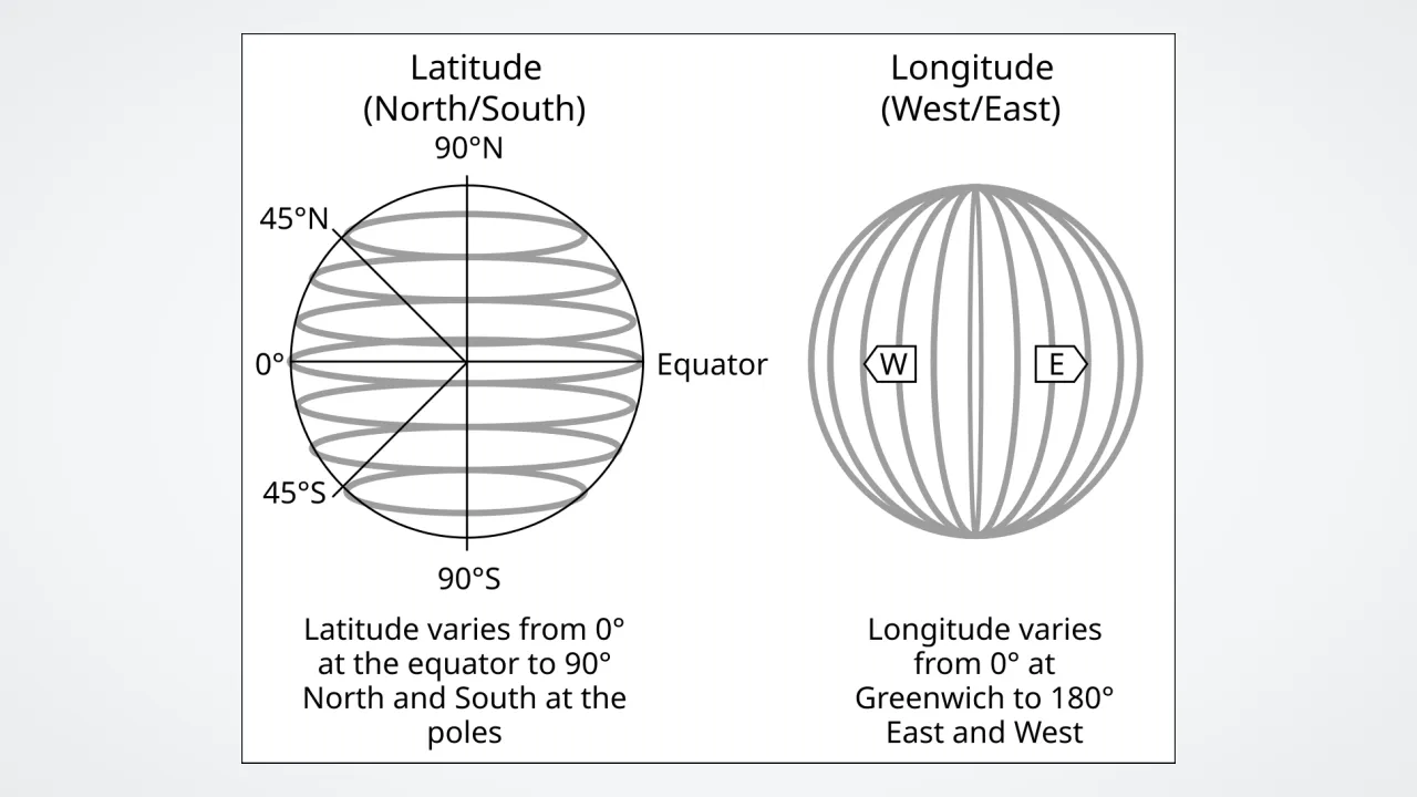
1. Which lines wrap flat around Earth like rungs on a ladder?
2. How many numbers do pilots and sailors need to pinpoint a spot on the globe grid?
🤯 Mind-Blowing Fact • Grade 2
Every single degree of latitude north or south equals about sixty-nine miles on the ground anywhere on planet Earth!
✨ Word Sparks (Grade 2 Glossary)
Tap 🔊 to hear
Parallel
Side-by-side lines that never cross each other
Coordinates
Number pair showing an exact map spot
Degree
Unit (°) used to measure globe angles
🪝
How can an ocean without streets, signs, or mailboxes still give every wave its own exact address?
1
Earth's Invisible Checkerboard
In your neighborhood, houses have street names and numbers so mail carriers never get lost. Out on deserts, ice sheets, and open oceans, mapmakers invented an invisible checkerboard called the latitude and longitude grid!
2
Parallels From the Equator
Horizontal circles called of latitude start at zero along Earth's middle Equator. They count upward to 90 degrees North at the North Pole and downward to 90 degrees South at the South Pole without ever touching each other.
3
Meridians From Pole to Pole
Vertical lines called meridians of longitude slice from North Pole to South Pole like segments of a peeled orange! Starting at zero in Greenwich, England, they count up to 180 degrees East and 180 degrees West.
1. What are meridians of longitude shaped like on a round globe?
2. What number is given to Earth's Equator on the latitude scale?
🤯 Mind-Blowing Fact • Grade 3
Even though scientists speak of 'minutes' and 'seconds' of latitude, those units measure tiny slices of a circle—not ticking clock time!
✨ Word Sparks (Grade 3 Glossary)
Tap 🔊 to hear
GPS
Satellite system finding exact locations on Earth
Arcminute
One-sixtieth of a single map degree
Intersect
To cross over at one shared point
🪝
Why do latitude rings shrink smaller toward the poles while longitude lines stay the exact same length?
1
Reading Coordinates in Order
Whenever pilots, ship captains, or scientists write geographic coordinates, latitude ALWAYS comes first and longitude comes second! For example, Richmond, Virginia sits near 37.5° N, 77.4° W—meaning 37.5 degrees north of the Equator and 77.4 degrees west of the Prime Meridian.
2
Shrinking Circles vs. Equal Halves
Look closely at a globe's geometry! The Equator is the longest parallel of latitude, wrapping 24,901 miles around Earth's middle. As latitude rings step closer to the icy poles, each ring shrinks smaller and smaller! Meridians of longitude, however, are all equal half-circles from pole to pole.
3
Zooming In With Minutes and Seconds
Sixty-nine miles between degrees is way too big to find one hiking tent! So mapmakers split each degree into 60 'minutes' (') and each minute into 60 'seconds' (")—pinpointing spots within steps!
4
GPS in Your Pocket
Today, dozens of orbiting satellites beam radio timing signals so phones and rescue helicopters read exact coordinates instantly.
1. When writing coordinates like 37.5° N, 77.4° W, which measurement always goes first?
2. Which parallel of latitude forms the biggest circle all the way around Earth?
🤯 Mind-Blowing Fact • Grade 4
The North American border between the United States and western Canada follows one single invisible parallel—49 degrees north latitude—for more than 1,200 straight miles from Minnesota to the Pacific Coast!
✨ Word Sparks (Grade 4 Glossary)
Tap 🔊 to hear
Graticule
Network of latitude and longitude map lines
Temperate Zone
Mid-latitude climate band with four distinct seasons
Converge
To come closer together and finally meet
🪝
Why does latitude control how cold or tropical a place feels while longitude controls what time your watch reads?
1
Two Coordinates, Two Planetary Powers
Latitude and longitude do far more than label spots on Virginia classroom wall maps—each coordinate links directly to a major Earth-Sun rule! Because latitude measures angular distance north or south of the Equator (0° to 90°), your latitude determines how steeply sunlight hits your town and divides Earth into tropical (0°–23.5°), temperate (23.5°–66.5°), and polar (66.5°–90°) climate zones. Longitude (0° to 180° E or W), by contrast, tracks how far east or west you sit around spinning Earth, governing local solar time!
2
Ancient Roots of the Graticule
Cartographers call this spherical network of parallels and meridians a '.' More than two thousand years ago in Alexandria, Greek scholars Eratosthenes, Hipparchus, and Claudius Ptolemy laid out numbered latitude and longitude grids across maps of the Mediterranean world—borrowing 360-degree circle math originally developed in ancient Babylon!
3
Converging Longitude Miles
While one degree of latitude stays roughly 111 kilometers (69 miles) everywhere from Kenya to Canada, one degree of longitude shrinks dramatically as meridians squeeze together! At the Equator, one degree of longitude spans 111 kilometers; in Virginia near 38°N it spans about 88 kilometers; and right at the poles it shrinks to zero!
4
Four Quadrants of the Globe
Crossing the Equator with the Prime Meridian divides Earth into four neat coordinate quadrants: NE, NW (including all of North America!), SE, and SW.
1. Why does one degree of longitude cover fewer miles in Virginia than it does at the Equator?
2. In which coordinate quadrant does Virginia (along with the entire continental United States) sit?
🤯 Mind-Blowing Fact • Grade 5
Airline jets flying from New York to Tokyo curve high up near Alaska instead of flying straight east-west across a flat Mercator map because curving over high latitudes follows a shorter 'great circle' shortcut on round Earth!
✨ Word Sparks (Grade 5 Glossary)
Tap 🔊 to hear
Oblate Spheroid
Sphere slightly flattened at poles by spinning
Great Circle
Largest sphere circle marking shortest travel path
Projection
Mathematical method flattening round Earth onto paper
🪝
Why is one degree of latitude actually slightly longer near the icy poles than at the Equator on our spinning, slightly squashed planet?
1
Geocentric Angles on an Oblate Spheroid
At first glance, planet Earth looks like a flawless marble in space, yet rapid daily rotation bulges the Equator outward so Earth's equatorial diameter (12,756 km) exceeds its pole-to-pole diameter (12,714 km) by 42 kilometers! Geodesists model this slightly flattened '' using the World Geodetic System 1984 (WGS 84) ellipsoid. Because polar curvature flattens slightly, traveling one geodetic degree of latitude requires ~110.57 kilometers at the Equator versus ~111.69 kilometers near 90°N or 90°S!
2
Great Circles vs. Small Circles
In spherical geometry, a '' slices a sphere into two equal halves directly through its center—representing the shortest flight path between any two points on Earth! Every meridian pair (such as 0° and 180°) forms a great circle, whereas among all parallels of latitude ONLY the Equator is a great circle; every other parallel is a 'small circle' whose circumference shrinks by the cosine of latitude.
3
Sexagesimal DMS vs. Decimal Degrees
Navigators express coordinates either in Babylonian base-60 Degrees-Minutes-Seconds (for example, Cape Henry Lighthouse in Virginia at 36°55'35" N, 76°00'26" W—where 1 latitude arcminute equals 1 nautical mile, or 1,852 meters!) or in signed decimal degrees (+36.9264, -76.0072) preferred by GIS databases, where southern latitudes and western longitudes carry minus signs.
4
Map Projections and Inevitable Distortion
As mathematician Carl Friedrich Gauss proved, peeling a curved spherical graticule onto a flat rectangular map inevitably stretches area, shape, distance, or direction—explaining why Greenland looks huge on a classroom Mercator despite having one-fourteenth the land area of Africa!
5
Global Navigation Satellite Systems (GNSS)
Today, constellations of GPS, Galileo, GLONASS, and BeiDou satellites broadcast nanosecond-timed signals from ~20,200 kilometers altitude, trilaterating 3D latitude, longitude, and ellipsoid height down to centimeters for tectonic plate monitoring, precision farming, and search-and-rescue.