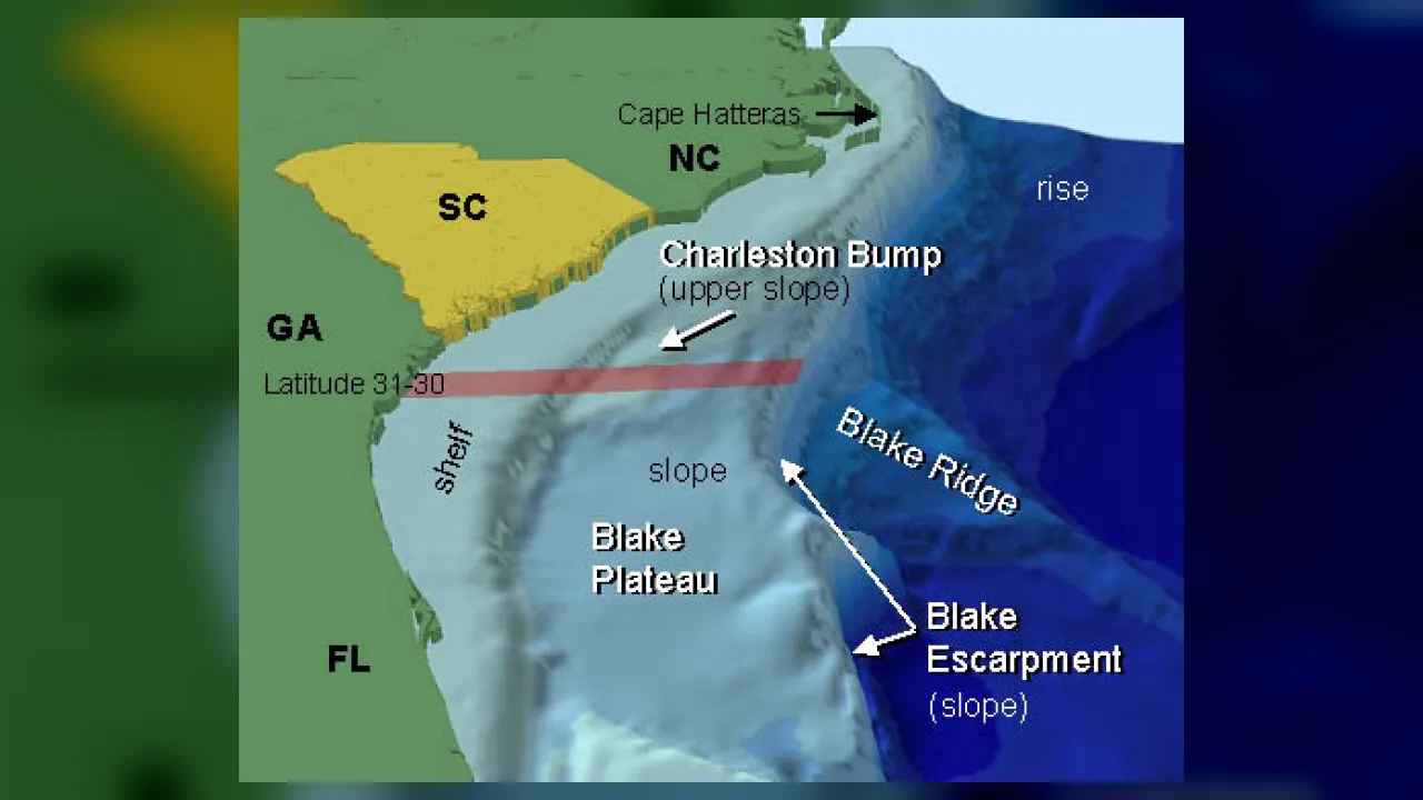
🌋 Where It FormsShallow underwater rim bordering continents from beach to shelf break
💎 Key PropertiesGentle granite crust apron bathed in sunlight and river nutrients
⚡ Planet Earth SparkCovers ~8% of the ocean floor yet shelters ~90% of marine sea life
🤯 Mind-Blowing Fact • Grade 1
During the Ice Age, ocean levels were lower and woolly mammoths walked across dry continental shelves where fish swim today!
✨ Word Sparks (Grade 1 Glossary)
Tap 🔊 to hear
Continental Shelf
Shallow underwater land edge around a continent
Shallow
Not very deep from top to bottom
Continent
One of Earth's giant main land masses
🪝
Does the ocean get miles deep the second you step off the beach?
1
A Gentle Underwater Ramp
Wade into the waves at a sandy beach! Under your toes, the land does not drop straight down. Instead, a wide gentle ramp stretches far out under water.
2
Sunny Sea Gardens
Scientists call this rim the . Bright sunshine reaches all the way to the sandy bottom!
3
Home for Most Fish
Sea grass, colorful corals, crabs, turtles, and playful dolphins crowd onto this bright, food-rich ledge.
1. What is the continental shelf like right off most beaches?
2. Why can so many sea plants grow on the continental shelf?
🤯 Mind-Blowing Fact • Grade 2
Commercial fishing boats have accidentally pulled up fossil mammoth teeth from fifty miles out on the Atlantic continental shelf!
✨ Word Sparks (Grade 2 Glossary)
Tap 🔊 to hear
Shelf Break
Outer edge where the shallow shelf drops steeply
Continental Slope
Steep underwater hill dropping past the shelf
Kelp
Tall brown seaweed growing in shallow sunlit seas
🪝
Where does a continent truly end—at the sandy beach or miles out under the waves?
1
Continents Wear Underwater Skirts
Look at a world map and trace the edge of North America! Surprise—the real edge of our continent does not stop at the wet beach sand. Every continent wears a flooded, gently sloping rim of land called the continental shelf!
2
Walking to the Drop-Off
Off Virginia and New Jersey, you could walk more than sixty miles eastward along the seafloor and stay in water less than six hundred feet deep! Finally, you reach the , where the steep plunges into the dark deep sea.
3
Bustling Ocean Neighborhoods
Rivers wash plant nutrients onto the shelf, and sunlight warms the shallow water. That combo makes continental shelves the busiest neighborhoods in the ocean!
1. What happens at the outer edge of the continental shelf, called the shelf break?
2. Why did woolly mammoths once walk out on the Atlantic continental shelf?
🤯 Mind-Blowing Fact • Grade 3
Siberia's Arctic Shelf north of Russia is the widest continental shelf on Earth, stretching up to 930 miles (1,500 kilometers) offshore into the Arctic Ocean!
✨ Word Sparks (Grade 3 Glossary)
Tap 🔊 to hear
Granite Crust
Thick light-colored rock forming Earth's continents
Submarine Canyon
Steep underwater valley cut into a shelf
Basalt
Dark dense volcanic rock forming deep seafloors
🪝
Why is the continental shelf super wide off Virginia and Florida, yet skinny off California?
1
Made of Continental Granite
Even though salty waves roll overhead, the continental shelf belongs geologically to the continent—built of thick covered in sand and mud, rather than thin dark like the deep ocean floor! Globally, shelves average about forty miles wide and slope gently to roughly 130 to 200 meters (430 to 650 feet) deep.
2
Wide East Coast vs. Narrow West Coast
Compare America's two ocean coasts! Along the quiet Atlantic coast from Maine past Virginia to Florida, no tectonic plates crash together, so eroded river sand has built a wide, gentle shelf up to eighty miles across. Along California and Chile, crashing plates and subduction trenches leave only a narrow shelf a few miles wide!
3
Submarine Canyons
Cutting right across many shelves are dramatic underwater valleys called —like the Hudson Canyon off New York and Norfolk Canyon off Virginia—carved by ancient Ice Age rivers and underwater mudslides.
4
Tiny Area, Huge Marine Life
Although continental shelves cover only about eight percent of all ocean area, they support roughly ninety percent of marine fish, kelp forests, oyster beds, and coral reefs!
1. Why is North America's Atlantic continental shelf much wider than its Pacific continental shelf?
2. Roughly what fraction of ocean area do continental shelves cover, and how much marine life lives there?
🤯 Mind-Blowing Fact • Grade 4
Twenty-seven miles east of Virginia Beach, clean-energy engineers anchored massive offshore wind turbines directly into the shallow Atlantic continental shelf to power hundreds of thousands of homes!
✨ Word Sparks (Grade 4 Glossary)
Tap 🔊 to hear
Continental Margin
Combined underwater shelf, slope, and rise zone
Turbidity Current
Fast underwater avalanche of dense muddy water
Continental Rise
Gentle sediment apron at the slope's bottom
🪝
What hidden underwater steps connect Virginia Beach to the flat abyssal plain three miles down?
1
The Three-Step Continental Margin
Board an oceanographic research vessel departing Norfolk, Virginia, and watch the sonar depth finder trace three classic steps of the ! For the first seventy miles eastward, the seafloor dips so gently—less than a tenth of one degree—that if it were dry land, it would look completely flat! That sunlit terrace is the continental shelf. At a depth around 130 to 200 meters, you cross the shelf break and plunge down the steep continental slope.
2
Turbidity Currents and the Continental Rise
At the base of the continental slope, piles of sand and mud form a gentler apron called the , which finally flattens onto the deep abyssal plain. How did land sand get three miles deep? Underwater avalanches of heavy muddy water—called —roar down submarine canyons like Norfolk and Baltimore canyons, dumping deep-sea sediment fans!
3
Beringia and Ice Age Bridges
During the peak of the last Ice Age twenty thousand years ago, global sea levels sat roughly 120 meters (400 feet) lower than today. Exposed continental shelves connected Alaska to Siberia across the Bering Land Bridge and united Britain with mainland Europe!
4
Clean Wind and Coastal Resources
Today, shallow shelves supply vital seafood harvests, sand for eroded beaches, and steady ocean breezes—such as the offshore wind turbines anchored into the sandy continental shelf twenty-seven miles east of Virginia Beach.
1. What underwater event builds the gently sloping continental rise at the bottom of the continental slope?
2. Why is the continental shelf off Virginia well suited for offshore wind turbines?
🤯 Mind-Blowing Fact • Grade 5
Scientists drilling off New Jersey and New England discovered a giant hidden aquifer of fresh Ice Age meltwater trapped underneath salty seafloor sediments miles out on the Atlantic continental shelf!
✨ Word Sparks (Grade 5 Glossary)
Tap 🔊 to hear
Passive Margin
Quiet continental edge far from tectonic plate boundaries
Neritic Zone
Shallow sunlit ocean water above continental shelves
Eustatic
Worldwide change in global ocean sea level
🪝
Why does the average shelf break worldwide sit around 130 meters deep—the exact depth of the last Ice Age shoreline?
1
Passive vs. Active Continental Margins
Examine global bathymetric maps compiled from satellite altimetry and shipboard multibeam sonar, and continental shelves reveal Earth's tectonic history in stark relief. Geologically, shelves are flooded extensions of buoyant felsic continental crust (~30–40 kilometers thick, density ~2.7 g/cm³) rather than dense mafic oceanic crust (~7 kilometers thick, density ~3.0 g/cm³). Along trailing-edge —such as North America's Atlantic coast, formed when Pangaea rifted apart 200 million years ago—subsiding crust traps kilometers-thick sedimentary wedges up to 300 kilometers wide. Along convergent active margins like the Andes and Cascades, subduction scrapes or swallows sediment, leaving narrow shelves averaging under 20 kilometers.
2
Eustatic Sea-Level Memory at 130 Meters
Across most of the planet, the shelf break—where a gentle ~0.1-degree shelf gradient steepens abruptly to a ~4-degree continental slope—sits near 130 meters depth (except Antarctica, where heavy ice-sheet weight pushes the continent down so shelves sit 400–500 meters deep!). That 130-meter global average is no coincidence: during the Last Glacial Maximum ~21,000 years ago, continental ice sheets locked up enough ocean water to drop sea level by ~120–130 meters, allowing waves and rivers to plane shelves flat right out to the modern shelf break!
3
Neritic Productivity and Photic-Benthic Coupling
Oceanographers call the water column over the continental shelf the neritic province. Unlike the open pelagic ocean—where dead organic matter sinks thousands of meters out of reach—shallow neritic shelves keep the seafloor close to or inside the sunlit photic zone. Winter storms, tidal mixing, river plumes, and coastal upwelling rapidly recycle seafloor nutrients back into sunlit waters, sustaining dense kelp forests, seagrass meadows, bivalve reefs, and global demersal fisheries.
4
Relict Sands, Paleo-Channels, and Methane Hydrates
High-resolution seismic reflection profiles beneath the Mid-Atlantic shelf reveal buried paleo-valleys of the ancient Susquehanna (ancestral Chesapeake Bay) and Delaware rivers, alongside vast pockets of fresh Ice Age groundwater trapped beneath salty seabed clays!
5
Maritime Law and Ecosystem Stewardship
Under international maritime frameworks (Exclusive Economic Zones extending 200 nautical miles offshore), coastal nations manage continental shelf fisheries, sand nourishment reserves, submarine fiber-optic cables, and renewable offshore wind while establishing marine sanctuaries around fragile shelf-edge cold-water corals.