💎 EARTH SCIENCE
🪨 Central North American Severe Convective Climatology Corridor
VA Science SOL 1.6, 2.6, 3.7, 4.4, 4.7, 5.8 (Weather, Rocks, Oceans & Earth Systems)
Tornado Alley
Where Giant Air Masses Collide Across America
Grade 3 • Fluent • 160 words
🌍 Earth Science TypeClimatology, Physical Geography & Severe Weather
🌋 Where It FormsCentral U.S. Great Plains from Texas through Oklahoma, Kansas, and Nebraska
1. Why is the middle of the United States nicknamed 'Tornado Alley'?
2. Where is the safest place to go if a Tornado Warning sounds for your town?
🤯 Mind-Blowing Fact • Grade 2
Two weather forecasters in Oklahoma first invented the nickname 'Tornado Alley' in 1952 while studying how to predict severe storms!
✨ Word Sparks (Grade 2 Glossary)
Tap 🔊 to hear
air mass
huge body of air with matching temperature and moisture
Gulf of Mexico
warm sea south of the United States
collide
crash or push strongly into one another
🪝
How do tall mountains in the west and a warm sea in the south team up to spin tornadoes?
1
No Mountains Blocking the Way
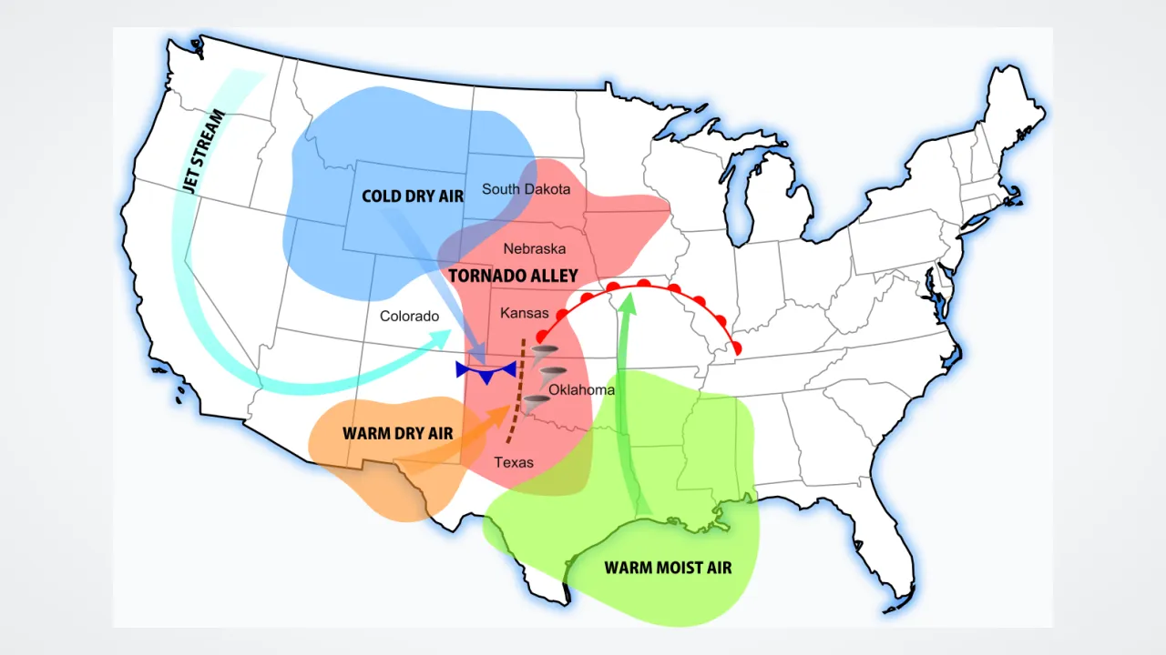
Unroll a map of North America and trace your finger north from Texas through Oklahoma, Kansas, and Nebraska. Notice how no east-to-west mountain wall blocks the middle of the continent! That open hallway is famously called Tornado Alley.
2
Three Kinds of Air Collide
Every spring, warm, sticky air streams north from the near the ground. At the same time, dry desert air pushes in from the southwest, while chilly, fast winds rush east high over the Rocky Mountains!
3
Safety Everywhere Matters
When those three , strong supercell storms spin up! Even though Tornado Alley sees many twisters, tornadoes can happen in every U.S. state, so knowing your safe shelter spot helps everywhere.
1. Where does the warm, humid ground air in Tornado Alley blow in from?
2. Can tornadoes only happen inside the states of Tornado Alley?
🤯 Mind-Blowing Fact • Grade 3
On March 25, 1948, Air Force meteorologists Ernest Fawbush and Robert Miller issued history's first successful tornado forecast at Tinker Air Force Base in Oklahoma!
✨ Word Sparks (Grade 3 Glossary)
Tap 🔊 to hear
dryline
boundary where hot dry desert air meets humid air
EF Scale
0-to-5 scale rating tornado wind strength from damage
corridor
broad pathway where weather patterns travel
🪝
Why doesn't Europe or South America have a giant 'Tornado Alley' shaped quite like North America's?
1
A One-of-a-Kind Map
Spin a globe and compare continents! In Europe, the tall Alps run east to west, blocking warm Mediterranean Sea air from crashing freely into cold northern air. North America is built completely differently: the towering Rocky Mountains run north to south right beside wide, flat Great Plains and the warm Gulf of Mexico!
2
Meet the Dryline
Spring afternoons across Texas, Oklahoma, and Kansas add a third secret player: hot, bone-dry air blowing downhill from the Chihuahuan Desert and Southwest plateaus. The sharp boundary where dry desert air shoves against sticky Gulf air is called the —a prime launchpad for supercells!
3
Marching North With Spring
Peak tornado season shifts north as sunshine warms the continent: starting along the Gulf Coast and Southern Plains in March and April, peaking in Oklahoma and Kansas in May, and reaching Nebraska, Iowa, and the Dakotas by June!
4
Measuring Strength: The EF Scale
After a tornado passes, meteorologists inspect building and tree damage to rate wind speeds from EF0 up to EF5 on the Enhanced Fujita Scale.
1. Why does North America's mountain layout build more tornado storms than Europe's Alps?
2. What happens along the 'dryline' in Texas, Oklahoma, and Kansas?
🤯 Mind-Blowing Fact • Grade 4
Without a warm 'capping lid' of elevated desert air holding storms back until late afternoon, Tornado Alley would mostly get ordinary morning rain showers instead of explosive supercells!
✨ Word Sparks (Grade 4 Glossary)
Tap 🔊 to hear
capping inversion
warm air layer holding rising moisture back temporarily
Tornado Watch
alert meaning storm ingredients could form tornadoes
Tornado Warning
urgent alert to take shelter immediately now
🪝
How does a warm layer of desert air act like a lid on a boiling pot before afternoon storms explode in Tornado Alley?
1
The Secret Lid: Capping Inversions
If warm, humid Gulf air met cold upper air all morning long, dozens of weak, messy rain showers would pop up before noon and use up all the sky's energy! Instead, Tornado Alley adds a remarkable fourth ingredient called 'the cap.' Warm, dry air streaming northeastward off Mexico's high desert plateaus slides about 1,500 meters above the sticky Gulf ground air. That warm layer acts like a lid on a simmering pot—holding moist air trapped near the ground all day while spring sunshine heats it hotter and hotter!
2
Breaking the Cap at Late Afternoon
By four or five o'clock in the afternoon, convergence along a cold front or dryline finally punches a hole right through that warm cap! Pent-up unstable fuel rockets skyward all at once into isolated, towering supercell thunderstorms while strong jet-stream wind shear spins their updrafts.
3
Dixie Alley and Shifting Storm Tracks
Importantly, Tornado Alley is a media nickname rather than an official National Weather Service boundary! A second major hotspot—often called 'Dixie Alley'—stretches across Mississippi, Alabama, Tennessee, and neighboring Mid-South states, while springtime cold fronts also bring tornadoes across the Appalachians into Virginia. In fact, recent multi-decade weather records show tornado outbreaks increasingly shifting eastward toward the Mississippi and Ohio River valleys!
4
Watches vs. Warnings
Knowing two alert words keeps every classroom and family ready: a means sky ingredients are favorable ('be prepared!'), while a means radar or spotters see rotation right now ('take shelter immediately!').
1. How does an elevated 'cap' of warm desert air actually make late-afternoon storms stronger in Tornado Alley?
2. What is the critical difference between a Tornado Watch and a Tornado Warning?
🤯 Mind-Blowing Fact • Grade 5
Argentina's Pampas east of the high Andes Mountains and Bangladesh south of the Himalayas are the closest geographic cousins to America's Tornado Alley anywhere else on Earth!
✨ Word Sparks (Grade 5 Glossary)
Tap 🔊 to hear
Elevated Mixed Layer
warm dry plateau air riding above humid plains
Low-Level Jet
fast ribbon of wind near one kilometer up
physiographic
shaped by landforms like mountains, plains, and seas
🪝
Why are climatologists observing an eastward shift in U.S. tornado outbreaks from the classic Great Plains toward the Mississippi Valley and Southeast?
1
Physiographic Perfection for Severe Convection
Coined in 1952 by U.S. Air Force meteorologists Major Ernest Fawbush and Captain Robert Miller, 'Tornado Alley' describes a remarkable coincidence unmatched anywhere else on Earth—save perhaps smaller corridors in Argentina's Pampas and Bangladesh's Ganges Delta. North America pairs a 4,000-meter north–south cordillera (the Rocky Mountains) directly west of vast, unobstructed interior plains bordered on the south by the warm, 26-degree-Celsius loop current of the Gulf of Mexico.
2
Low-Level Jets, Elevated Mixed Layers, and Wind Shear
During spring synoptic troughs, surface lee cyclogenesis east of the Rockies accelerates a southerly Great Plains (LLJ) at 500 to 1,000 meters altitude, pumping rich Gulf moisture northward while simultaneously sharpening low-level directional wind shear. Overhead, arid air heated across the Mexican Plateau advects northeastward between 1,500 and 4,000 meters as an (EML), combining steep mid-level lapse rates (~8.5°C per kilometer) with a potent capping inversion that suppresses premature convection until dryline convergence triggers explosive supercells beneath screaming westerly polar-jet winds.
3
Ted Fujita and Mobile Doppler Field Campaigns
Pioneering researcher Tetsuya 'Ted' Fujita revolutionized tornado science in the 1970s by mapping multi-vortex suction swaths and introducing the Fujita Damage Scale (upgraded in 2007 to the engineering-calibrated Enhanced Fujita Scale, EF0–EF5). Subsequent Great Plains field campaigns like VORTEX and VORTEX2 deployed armada fleets of mobile Doppler radars to probe wind speeds exceeding 135 meters per second (300 mph)!
4
Climatological Shift Toward 'Dixie Alley' and the Mid-South
Analyzing four decades of tornado environments (1979–present), atmospheric scientists discovered a striking geographic trend: while annual U.S. tornado totals remain broadly steady (~1,200 per year), tornado days across the drier western High Plains have edged downward while outbreak frequency and winter–spring tornado days have climbed significantly eastward across the Middle Mississippi, Ohio, and Tennessee Valleys ('Dixie Alley').
5
Vulnerability, Nocturnal Storms, and Engineering Resilience
Forecasters emphasize that Mid-South and eastern outbreaks pose heightened human hazards due to dense forest cover, faster storm-motion speeds, higher nighttime frequency, and fewer underground basements—driving advances in NOAA Weather Radio alerts, storm-shelter engineering, and Phased-Array Radar.