🇺🇸 U.S. HISTORY
🏛️ Pre-Columbian Mississippian Metropolis • UNESCO World Heritage Site
VA History & Social Science SOL K.1, 1.2, 2.4, VS.1–VS.10, USI & USII
Cahokia Mounds Ancient City
America's Giant Ancient City of Earth
Grade 5 • Advanced • 380 words
⏳ Era / StatehoodFlourished c. 1050–1350 CE • Peak Population c. 1100–1200 CE
🗺️ Region / CapitalSouthern Illinois (Near Mississippi River & St. Louis)
📜 Key Milestone120 Earthen Mounds Including 100-Foot-Tall Monks Mound
⚡ Historical SparkLargest ancient Indigenous city north of Mexico—once home to more people than medieval London
🤯 Mind-Blowing Fact • Grade 1
Nearly nine hundred years ago, more people lived in the ancient city of Cahokia than in London, England!
✨ Word Sparks (Grade 1 Glossary)
Tap 🔊 to hear
mound
A large hill shaped out of earth
ancient
From a very long time ago
woven
Made by lacing strips tightly together
🪝
Did you know people once built hill-sized pyramids out of baskets of dirt?
1
Hills Made by Hands
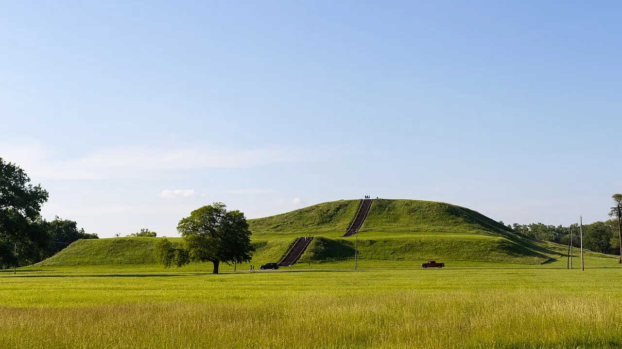
Look up at a grassy hill ten stories tall! Nearly one thousand years ago, Native builders made giant earth at Cahokia.
2
Basket by Basket
Workers had no trucks or horses. They carried baskets of heavy soil to build 120 near the Mississippi River!
3
A Busy Ancient City
Thousands of families farmed corn, played games, and watched the sunrise there. Today you can climb Monks in Illinois!
1. How did builders at Cahokia move all the soil to make giant mounds?
2. Near which famous river was the ancient city of Cahokia built?
🤯 Mind-Blowing Fact • Grade 2
Monks Mound at Cahokia has a base covering more than fourteen acres—even wider than the Great Pyramid of Giza in Egypt!
✨ Word Sparks (Grade 2 Glossary)
Tap 🔊 to hear
plaza
A wide open town square for gatherings
fertile
Rich soil where crops grow very well
astronomer
Someone who studies stars, sun, and sky
🪝
What was life like inside North America's biggest ancient city nine hundred years ago?
1
Welcome to Ancient Cahokia
Hear the cheering crowd echo across a huge flat ! Around the year 1100, up to twenty thousand Mississippian people lived in Cahokia in present-day southern Illinois. Farmers grew rich fields of corn, squash, and sunflowers in the river valley.
2
Towering Monks Mound
Builders carried baskets of clay and soil to construct 120 flat-topped mounds. The tallest, called Monks Mound, rises one hundred feet high and covers fourteen acres—wider at the bottom than Egypt's Great Pyramid!
3
Tracking the Sun
Cahokian also stood tall cedar logs in giant circles called Woodhenge to track the sun and mark planting seasons.
1. What is the name of the tallest earthen mound at Cahokia?
2. Why did Cahokians build big circles of tall cedar posts called Woodhenge?
🤯 Mind-Blowing Fact • Grade 3
Cahokians loved an exciting sport called 'chunkey,' where athletes threw wooden spears to land as close as possible to where a polished rolling stone disc would stop!
✨ Word Sparks (Grade 3 Glossary)
Tap 🔊 to hear
metropolis
A very large, busy, important city
floodplain
Flat river valley enriched by seasonal floods
equinox
Day when daytime and nighttime are equal
🪝
How did engineers without metal tools or wheeled carts build a city of 120 earthen mounds and a solar calendar?
1
Crossroads of Great Rivers
Stand atop a breezy terrace in southern Illinois where the Mississippi, Missouri, and Illinois rivers meet! Around 1050 CE, Mississippian planners transformed this fertile into Cahokia—a bustling of thatched homes, neighborhoods, and plazas housing between ten thousand and twenty thousand residents.
2
Engineering Monks Mound
Moving roughly fifty-five million cubic feet of earth in forty-pound woven baskets, workers layered alternating bands of sand and clay so rainwater would drain safely without collapsing the slopes. Their centerpiece, Monks Mound, rose one hundred feet high in four terraces topped by a massive wooden temple or leader's hall.
3
Woodhenge and Chunkey Games
West of Monks Mound stood Woodhenge, a ring of red cedar posts aligned with the spring and autumn and solstices. Below in the forty-seven-acre Grand Plaza, crowds cheered players hurling spears at rolling stone discs in a game called chunkey.
4
A Continental Trade Hub
Cahokia connected waterways across North America, trading for Lake Superior copper, Gulf Coast seashells, and glittering Appalachian mica before residents gradually dispersed by 1350 CE.
1. Why did Cahokia's builders alternate layers of sand and clay inside Monks Mound?
2. Which goods traveled along river trade routes to reach Cahokia?
🤯 Mind-Blowing Fact • Grade 4
No city in the future United States matched ancient Cahokia's peak population again until Philadelphia grew past twenty thousand people around the time of the American Revolution!
✨ Word Sparks (Grade 4 Glossary)
Tap 🔊 to hear
pre-Columbian
Existing in the Americas before 1492
stockade
Protective wall built of tall upright logs
solstice
Longest summer day or shortest winter day
🪝
Why did Cahokia boom into North America's greatest medieval city around 1050 CE—and why had its residents left by 1350?
1
The 'Big Bang' in the American Bottom
Paddle a dugout canoe down the Mississippi River around 1100 CE and watch a skyline of plastered timber halls and geometric earthen pyramids rise out of the mist! Located in the fertile floodplain called the American Bottom across from modern St. Louis, Cahokia expanded rapidly around 1050 CE into a planned city covering six square miles, making it larger than any European city in Britain at the time and unsurpassed in population anywhere in the future United States until Philadelphia in the 1780s.
2
Masterpieces of Soil Architecture
Cahokian civic planners leveled a forty-seven-acre Grand Plaza so flat that footraces and chunkey tournaments could unfold before thousands of spectators. Dominating its northern edge stood Monks Mound—named centuries later after French Trappist monks who gardened nearby in the 1800s—containing roughly twenty-two million cubic feet of hand-carried earth alone and crowned by a fifty-foot-tall council building visible for miles.
3
Solar Science and Fortified Walls
Archaeologists uncovered five successive circles of red cedar posts—nicknamed Woodhenge—where solar priests stood on a central platform to watch the sun rise directly behind perimeter posts on the equinoxes and . Around the central precinct, workers also erected a two-mile-long defensive wall using nearly twenty thousand upright logs.
4
Mystery of the Dispersal
Between 1200 and 1350 CE, shifting climate patterns brought both severe droughts and major floods, straining wood supplies and intensive maize harvests. Cahokia's families gradually migrated to join descendant Indigenous nations across the Midwest and Plains, and in 1982 Cahokia Mounds State Historic Site became a UNESCO World Heritage Site.
1. How did Monks Mound get its modern English name?
2. What environmental challenges likely contributed to people leaving Cahokia by 1350 CE?
🤯 Mind-Blowing Fact • Grade 5
Archaeologists analyzing ancient lake-bed mud cores at Cahokia discovered pollen and flood-sediment layers proving that massive Mississippi River megafloods struck the city around 1150–1200 CE!
✨ Word Sparks (Grade 5 Glossary)
Tap 🔊 to hear
confluence
Place where two or more rivers meet
palisade
Defensive fence made of tall wooden stakes
cosmology
Understanding of the universe and sky order
🪝
How do archaeology, soil engineering, and archaeoastronomy reveal the sophistication of Mississippian urban planning at Cahokia?
1
Urban Planning at Continental Crossroads
Climb the 154 steps to the summit of Monks Mound in Collinsville, Illinois, and look west toward the St. Louis Gateway Arch gleaming eight miles away across the Mississippi River. Nine centuries ago, this six-square-mile expanse in the American Bottom floodplain formed the heart of Cahokia, the preeminent metropolis of the Mississippian culture (c. 1050–1350 CE). Positioned near the of the Mississippi, Missouri, and Illinois rivers, Cahokia commanded waterborne trade networks stretching from the Great Lakes to the Gulf of Mexico and supported an estimated 15,000 to 20,000 inhabitants at its twelfth-century zenith.
2
Geotechnical Genius Without Draft Animals
Without wheeled vehicles, beasts of burden, or metallurgy for digging tools, Cahokians quarried soil with stone and mussel-shell hoes and hauled an estimated fifty-five million cubic feet of earth in woven baskets to construct roughly 120 mounds—80 of which survive today. Platform mounds supported civic buildings and elite residences, conical mounds marked burials, and ridgetop mounds framed sacred boundaries. Monks Mound, rising 100 feet (30 meters) across a fourteen-acre footprint larger than Egypt's Great Pyramid of Khufu, incorporated engineered sand drainage layers and clay buttresses to counteract swelling floodplain soils.
3
Cosmology, Woodhenge, and the Grand Plaza
Archaeologists discovered that Cahokia was laid out along a precise north-south, east-west cosmological axis rather than Growing haphazardly. Directly south of Monks Mound stretched the artificially leveled, forty-seven-acre Grand Plaza, surfaced with imported sand for ceremonial processions, markets, and chunkey matches. To the west, builders reconstructed Woodhenge at least five times between 1100 and 1200 CE, arranging up to sixty-foot red cedar posts in circles up to 410 feet wide so observers could sight the sunrise over Monks Mound on the vernal and autumnal equinoxes.
4
Trade, Craftsmanship, and Climatic Stress
Specialized workshops fashioned ceremonial flint hoes from Mill Creek chert, embossed copper plates from Lake Superior, mica cutouts from the southern Appalachians, and engraved marine whelk cups from the Gulf Coast. Yet sustaining tens of thousands of residents required immense timber—nearly 20,000 logs per reconstruction of the two-mile central alone. Sediment cores from Horseshoe Lake confirm catastrophic twelfth- and thirteenth-century floods alternating with prolonged droughts as the Medieval Warm Period transitioned toward the Little Ice Age.
5
Enduring World Heritage
By 1350 CE, Cahokia's urban population had decentralized into river valleys across the Midwest and Southeast, contributing ancestral heritage to Osage, Omaha, Ponca, Quapaw, Chickasaw, and related Indigenous nations. Designated a UNESCO World Heritage Site in 1982, Cahokia stands as timeless testimony to Indigenous urban engineering.